Country:

 City:
City:


You can reach the church at Avressieux from either Pont de Beauvoisin or Saint-Genix-sur-Guier.
You’ll easily find a parking space in the shade of the plane trees.
(S/E) Walk past the war memorial, heading towards “Sur les Vignes”. Follow the Route des Pentes. Pass the hamlet of La Verelle, then take the first road on the right. 300 m further on, you’ll come to a cross.
(1) Turn left onto the Toudan climb. At the top, just before a right-hand bend, take a small path on your left. Walk uphill under the trees, and you’ll soon be skirting a field. You’ll soon come to a tarmac road.
(2) At the next junction, turn right. Follow the road to Saint-Michel. Walk on until you reach the road to Saint-Genix.
(3) Head to the right. At the next junction, turn left. Carry straight on at the next junction. At the bottom of the descent, the path turns left.
(4) There, you’ll find a small path leading down to the right. Follow it to the Ruisseau du Truison. Cross the bridge, then head up the path opposite. You’ll soon come to a road. Follow it. At the next junction, carry on straight ahead, then take the road on the right. 200 metres further on, cross the Route de Rochefort again. Carry on to the chapel.
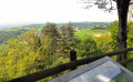
(5) Head back down to the junction leading to the town hall. Turn right onto the road towards Novalaise. Take great care on this section as you’ll be walking on the road and there’s quite a lot of traffic. Make your way to the viewpoint.
(6) Carry on a little further along the road. Soon, you’ll come to a signposted path on your right. Take it. You’ll soon reach a stony track. Turn right towards the ruins of Montbel Castle. After a good kilometre, you’ll come to a Fork in the road.
(7) Take the path on the left signposted for the ruins. Follow the signposts. After 600 metres, you’ll rejoin the stony track you left earlier. Head left. Carry on until you reach the Route de Montigon.
(8) Follow the signposts, which will take you off the road and up to the right. Walk for about 1 km until you reach a junction.
(9) Turn left and follow the signposts towards the Col du Banchet.
(10) Head straight ahead towards the Belvédère du Grand Bec. Follow the signposts all the way to the end.
(11) Retrace your steps until you find a path on your left heading towards Le Banchet.
The descent is quite tricky. There are very few signposts, the path isn’t very visible and in some places it’s quite narrow. At the sign telling you that the path to the Mandrin cave is closed, make sure you follow the instructions and head down to the right. Carry on until you reach the road leading down from the pass.
(12) Then turn left, pass the hairpin bend, then take the path on the left. Walk down to the junction.
(13) Carry on straight ahead. The road climbs up to the mast. Follow the path as it continues. Cross the first road, then you’ll reach the main road.
(14) Turn right, then left. Walk through the hamlet, then turn right until you reach a cluster of houses.
(15) Just before the right-hand bend, turn left onto the small road leading down towards the hamlet of Valléo. At the next junction, turn left. Continue downhill to the junction with the Route de Rochefort. Carry on straight ahead for 1 km towards Avressieux church (S/E).

 Visorando Member
 Easy
Easy