Country:

 City:
City:


Leave the village and park on the tarmac section in the three-way junction between the Route de Croix and the Route de Montbouton.
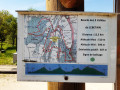
(S/E) Start the walk by leaving the car park and continuing left onto Route de Montbouton. Turn right after about a hundred metres, ignore the path branching off to the right towards the quarry, and carry on straight ahead along the track. Pass under the power line, then leave this track at the bend to climb up into the woods and reach the edge of the woodland.
(1) Turn right to walk alongside the woodland. Early in the morning, it’s not uncommon to spot roe deer, provided you walk quietly! At the end of the field, you enter the forest again and continue along the same path for about 300 metres.
(2) Turn right to follow this very pretty path which descends towards the bottom of the small valley. Watch out for slippery patches! Once at the bottom of the descent, cross the track used by lorries from the Saint-Dizier quarry and head back up the path directly opposite.
(3) At the top of the climb, take a hairpin bend to the left, following the ‘family walk’ sign. Cross the D57 and continue along the path opposite, which leads into the Bois Poireret.
(4) At the end of the climb, take a hairpin bend to the right and follow the path along the edge of the woodland, running parallel to the unpaved track visible on your left. When the path rejoins the D57, walk carefully along its left-hand side for about a hundred metres.
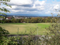
(5) Before turning right onto Rue des Esserts, take a moment to enjoy the view: straight ahead along the road, you can see the foothills of the Swiss Jura. Looking to your left, on a clear day, the Black Forest appears in the distance, and a little further to the left, you can see the Vosges. Follow Rue des Esserts until the junction with Rue Champs au Roi.
(6) Turn right, then, after about twenty metres, turn left onto the path which, a little further on, overlooks the quarry on your left. At the junction, turn left and head back to the car park where you started (S/E).



 Visorando Member

 Moderate
 Local authority
 Extremely difficult