Country:

 City:
City:


Saint-Jacques-d’Atticieux is a village situated in the Pilat Regional Park. Head to the centre of the village and park near the town hall; the walk starts from this point.
(S/E) From the town hall car park, head uphill towards the church, leaving the entrance on your right. At the church, turn right in front of the entrance, then follow Rue du Couvent straight ahead as it climbs. After about 50 metres, at the Fork in the road, turn left into Rue des Vents. Continue straight on to join Rue du Réservoir and carry on straight along this road, ignoring a path branching off to the left (Impasse des Chalets). You will reach a junction with a road.
(1) Follow this road downwards to the left, passing a green fire-fighting water tank on your right. After travelling about 150 m along this road, take the first path on the right, which almost goes in the opposite direction. Continue down this path, crossing the Ruisseau de la Pêche.
(2) At the hairpin bend, cross over a stream and carry on straight ahead, ignoring all the paths branching off to the right. At the second hairpin bend on the track, head towards the houses in the hamlet of Le Châtaignier, ignoring the Chemin des Croisettes on the right. In the hamlet, after a bend to the right, take the first left, then 40 metres further on, turn right, continue for another 40 metres or so, and you’ll reach a junction with several streets.
(3) Take the left-hand-most street, Rue Lachaux de Revoux, ignoring Rue du Minerai opposite. At the next junction, continue straight on along Chemin de la Madone.
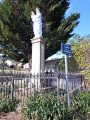
(4) Head left, pass by the foot of the Madone and continue straight on along Rue du Centre, passing through the hamlet of Le Revoux. You’ll reach the village of Brossainc whilst still following the same street.
(5) Turn right to go round the town hall and the church of Brossainc on the left, then immediately turn right across the Place des Anciens Combattants and head straight up Rue du Puits. Once at the end of the street, continue along Chemin de la Croix de Barnabé.
(6) At the cross, ignore Rue de la Chapelle, which branches off to the right, and carry on straight ahead. When you reach a crossroads, continue straight ahead uphill until you reach a tarmac road where there is a hiking signpost.
(7) Follow this road to the left until you reach the Croix du Jean, which stands to the right of the path. Then leave the tarmac road, which ends, and take the dirt track that continues straight ahead, ignoring the one on the left. Follow this track straight on until you reach a junction where a path branches off to the left, almost in the opposite direction to the one you are on.
(8) Take this path and continue downhill, ignoring the turn-offs to the left, until you reach an isolated house on the right, slightly below you. About a hundred metres after leaving the access path to this house, carry on straight ahead along the wide path until you come to a path branching off to the left: be careful, it’s easy to miss.
(9) Leave the wide, open path and follow this narrower path on the left through the woodland. Continue downhill until, about 250 metres further on, you reach a Fork in the road. Take the left-hand path downhill. During the descent, ignore a path branching off to the right and continue straight on until you reach the end of a road.
(10) Follow it to the right towards the houses in the hamlet of Mantelin. In the hamlet, take the first street on the right, Rue des Tilleuls. At the end of the street, carefully cross the Route de Charnas (D271), turn left for a few metres, then turn right onto the Route de Maclas. Follow this road for about sixty metres.
(11) Take a dirt track on the left and carry on straight ahead. When you reach a road, head to the right, towards a hiking signpost visible at this point. Continue left along the road, leaving the path junction on your right and following the sign for Brossainc indicated there. Further on, ignore a second junction on the right and arrive at a crossroads where there is also a hiking signpost.
(12) Turn left towards the small bridge and cross it. Continue to the right, ignoring a path branching off to the right, and carry on straight ahead uphill. At the end of this path, which leads across fields, you’ll reach a road.
(13) Turn left onto this road and follow it carefully towards the village of Saint-Jacques-d’Atticieux.
(13) Cross the D271 with care, continue straight ahead, passing the school on your right, and carry on straight on to reach the town hall car park (S/E).
 Visorando Member
 Easy
Easy