


 20/07/2023 Moderator’s note: The walk has been amended at point 6 to avoid private property and follow theGR® 7 to the ruins of Montaigu Castle.


 Country:
 City:
City:


Leave your car, for example, near Mercurey Town Hall, situated a few dozen metres from the fountain. Walk round it via the main street (D978 or Grande Rue).
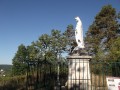
(S/E) Take this main road, pass the fountain (heading south-east) and turn into thefirst street on the left. At the small road, make a right-left zigzag. Continue uphill until you reach the statue of Mary. At the crossroads, take one of the paths straight ahead or slightly to the left (not the one going down to the far left). Follow the ridge northwards. You’ll reach the mill.
(1) Here you have two options:
- either complete the circular loop as indicated: a lovely path that descends gently,
- or take the short but steep path, which can be very slippery in places.
Rejoin theGR®76, marked in red and white. Follow it along the edge of the vineyards, skirting the woodland. You’ll reach the junction with Rue du Reu.
(2) Turn left onto the path running alongside the vineyards. Zigzag left-right-left through the narrow streets to reach the church at Mercurey.
(3) Take the street that continues from there – this is Rue du Pont Latin – which leads towards the pond.
Walk round the pond. There’s a wash house at the far end.
(4) When you reach the main road, cross it – watch out for cars – and climb the stone steps directly opposite. Take the narrow streets until you come to a path that climbs towards the south-west.
(5) At the fork in the road, take the path on the left. You’ll reach the edge of the vineyards; walk alongside them until you come out onto a road again.
(6) Turn right and rejoin theGR®76, which runs alongside this road until it meets theGR®7at a junction.
(7) Turn left onto this wide track, which follows theGR®7marked in red and white. A little further on, you’ll be able to see the ruins of Montaigu Castle.
(8) Leave theGR® and take the path on the left, which leads to Touches.
(9) Enter the hamlet and rejoin theGR®76, marked in red and white. Follow it northwards until you reach the junction with Rue de Martin Gault.
(10) Turn right onto this street to make your way back at a leisurely pace to the starting car park (S/E).

 Visorando Member
 Easy
Easy 

 Tourist office
 Association / Club / Walk leader
