Country:
 City:
City:


Parking is available on the grass verge along the Route de Lavedrenne at the eastern end of the village.
(S/E) Set off from the granite wayside cross on the stony path heading east. At the fork in the road a few dozen metres further on, turn right, then right again at the next fork. Ignore the paths branching off to the left until you reach the T-junction, then continue straight ahead.
Reach the bend in a forest track and continue straight on along the track for about a hundred metres.
(1) Leave the forest track to the left via a path marked by a Yellow Cross. In a wide right-hand bend, you’ll come to a Fork in the road.
(2) At the Fork in the road, turn right uphill. Continue southwards to reach the Route de Saint-Léger (D28a). Carry on straight along the road until thefirst bend.
(3) Leave the road by turning right, heading due west, onto the stony track. Keep heading in the same direction, after a bend to the left then to the right, until you reach the junction with the Route de Lavedrenne.
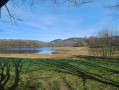
(4) Cross the road and follow the track westwards again. At Puy Gauthier, enjoy a very unobstructed view to the north-west. In clear weather, you can see the two towers of the Civaux power station on the horizon, 75 km away.
Continue along the track; after a wide bend to the right, you’ll reach a junction with Route de Bersac (D28). Turn sharply right and follow the road for about 300 m until you reach the start of a left-hand bend, where a path begins.
(5) At the junction marked ‘Red Route’, leave the road by taking the path on the right. Further on, the small stream can be easily crossed on the left. Upon reaching the village of Maillofargueix, turn right onto the ‘Red Route variant’, passing in front of a barn, and rejoin the exit from Maillofargueix onto the Route de Lavedrenne (S/E).

 Visorando Member
 Moderate
 Tourist office