Ficaghjola loop

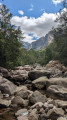
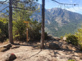
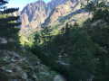
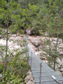
A family loop combining swimming and hiking. Set off to explore nature in the heart of the Bonifatu massif. Avoid in case of flood risk. The start of the Ficaghjola loop is at the bottom of the car park; first descend to the riverbank, then cross a footbridge before climbing up to the heights.

Details

12409792
Creation:
Last update:
Last review:
  • Walking
    Activity: Walking
  • ↔
    Distance: 2.64 mi
  • ◔
    Average duration: 2h 00 
  • ▲
    Difficulty: Easy

  • ⚐
    Back to start: Yes
  • ↗
    Ascent: + 879 ft
  • ↘
    Descent: - 853 ft

  • ▲
    Highest point: 2,461 ft
  • ▼
    Lowest point: 1,604 ft
  • ⚐ Country: France
  • ⚐
    Areas: Balagne,
  • ⚐ City: Calenzana (20214)
  • ⚑
    Start/End: N 42.442636° / E 8.854279°
  • ❏
    IGN map(s): Ref. 4149OT, 4250OT, 4250OTR
  • Hour-by-hour weather

Photos

Description of the walk

Park in the Bonifatu forest car park.

(S/E) Reach the river at a footbridge.

(1) Cross the Lamitu stream and turn right at the next crossroads onto the path going uphill. Stay on this path and, following a series of tight bends, you will reach a crossroads of paths at the Melaghia stream.

(2) Turn right to begin the descent, following the left bank of the stream at a distance. You will then come to a ford at the Lamitu stream.

(3) Cross and turn right. Follow the left bank of this stream to return to the Bonifatu car park (S/E).


Waypoints

  1. S/E : mi 0 - alt. 1,729 ft - parking forêt de Bonifato
  2. 1 : mi 0.18 - alt. 1,604 ft - Himalayan footbridge over the - Figarella (fleuve)
  3. 2 : mi 1.11 - alt. 2,411 ft - Crossroads, on the right - traversée du ruisseau de Melaghia
  4. 3 : mi 1.72 - alt. 2,021 ft - Ford
  5. S/E : mi 2.64 - alt. 1,729 ft - parking forêt de Bonifato

Notes

Good shoes.
Towel.

Worth a visit

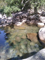
Swimming in the Figarella pools.

Reviews and comments

4.7 / 5
Based on 32 reviews

Reliability of the description
4.7 / 5
Ease of following the route
4.7 / 5
Route interest
4.7 / 5
cazzola
cazzola

Overall rating : 4.3 / 5

Date of your route : Jul 20, 2026
Reliability of the description : ★★★★☆ Good
Ease of following the route : ★★★★☆ Good
Route interest : ★★★★★ Very good
Very busy route : No

A lovely 2-hour family walk, with some beautiful natural pools to look forward to after an hour and a half.

Machine-translated

User 26439053

Overall rating : 4.7 / 5

Date of your route : Jul 20, 2026
Reliability of the description : ★★★★★ Very good
Ease of following the route : ★★★★☆ Good
Route interest : ★★★★★ Very good
Very busy route : No

A lovely walk, even when it’s very hot, as two-thirds of the route is through woodland.
Viso Rando was a great help, as the initial signposting was inadequate.

Machine-translated

User 29712836

Overall rating : 5 / 5

Date of your route : Jul 13, 2026
Reliability of the description : ★★★★★ Very good
Ease of following the route : ★★★★★ Very good
Route interest : ★★★★★ Very good
Very busy route : Yes

A pleasant and fairly easy walk. Well signposted. Quite a few shaded sections.

Machine-translated

Mag300872
Mag300872

Overall rating : 4.7 / 5

Date of your route : Jun 29, 2026
Reliability of the description : ★★★★★ Very good
Ease of following the route : ★★★★☆ Good
Route interest : ★★★★★ Very good
Very busy route : Yes

I wouldn’t describe this walk as suitable for families
The end of the route is certainly easy, with stops for a swim, but the start, which is quite steep, is much less suitable for children
A very enjoyable and varied walk. Woodland, beautiful views from the top of the peaks and a descent along the river
Paid car park: 5 euros at the end of June
However, it was longer than the 5 km advertised…
The start is well shaded, but the second half of the climb is in the sun
Thank you

Machine-translated

User 8696206

Overall rating : 5 / 5

Date of your route : Jun 23, 2026
Reliability of the description : ★★★★★ Very good
Ease of following the route : ★★★★★ Very good
Route interest : ★★★★★ Very good
Very busy route : No

A lovely walk
A challenging climb but in the shade and perfectly manageable; on the way back we were able to enjoy the natural pools (several spots to choose from) which were easily accessible
The water was very cool, but swimming was a pleasure
And a coffee at the Auberge de la Forêt on arrival rounded off the morning

Machine-translated

User 18258930

Overall rating : 5 / 5

Date of your route : Jun 18, 2026
Reliability of the description : ★★★★★ Very good
Ease of following the route : ★★★★★ Very good
Route interest : ★★★★★ Very good
Very busy route : Yes

We did this route in reverse, finishing at the footbridge, which makes for a gentler climb. A walking stick is recommended as the descent is very stony. Beautiful views of the Bonifato cirque.

Machine-translated

User 6981221

Overall rating : 5 / 5

Date of your route : May 01, 2026
Reliability of the description : ★★★★★ Very good
Ease of following the route : ★★★★★ Very good
Route interest : ★★★★★ Very good
Very busy route : No

A lovely walk. Free parking in May. Quite a steep climb at the start 😅. Beautiful views. Point number 3 can be tricky if you’re a bit scared, but you can still get past it. And to finish off, a quick beer at the Auberge de la Forêt 👍

Machine-translated

Jacques David
Jacques David

Overall rating : 5 / 5

Date of your route : Oct 29, 2025
Reliability of the description : ★★★★★ Very good
Ease of following the route : ★★★★★ Very good
Route interest : ★★★★★ Very good
Very busy route : No

Lovely walk, no problem crossing the fords.

Machine-translated

pbizet
pbizet

Overall rating : 5 / 5

Date of your route : Oct 01, 2025
Reliability of the description : ★★★★★ Very good
Ease of following the route : ★★★★★ Very good
Route interest : ★★★★★ Very good
Very busy route : No

A lovely hike, mostly shaded. Beautiful views and, at the end, stunning natural pools that are difficult to access.

Machine-translated

Frederico
Frederico

Overall rating : 4.7 / 5

Date of your route : Sep 22, 2025
Reliability of the description : ★★★★★ Very good
Ease of following the route : ★★★★★ Very good
Route interest : ★★★★☆ Good
Very busy route : Yes

A fairly easy hike, the climb takes about 40 to 45 minutes. Follow the blue markings. On the way back, you can swim at various spots. Parking is free in September

Machine-translated

marie de floreffe
marie de floreffe

Oops... I completely agree... my friend and I found the rattle in the passages annoying, especially the second one... but superb

Machine-translated

Sam_
Sam_

Overall rating : 4.7 / 5

Date of your route : Sep 15, 2025
Reliability of the description : ★★★★★ Very good
Ease of following the route : ★★★★★ Very good
Route interest : ★★★★☆ Good
Very busy route : No

A lovely short hike, with a steep climb at the beginning but no particular difficulty. Beautiful view of the Aiguille de Bonifato at the end of the climb. The descent is gentle, with a stop in the river for those who aren't afraid of cold water. No problem crossing the river during the hike. Not too crowded at this time of year.

Machine-translated

marie de floreffe
marie de floreffe

Overall rating : 3.3 / 5

Date of your route : Sep 08, 2025
Reliability of the description : ★★★☆☆ Average
Ease of following the route : ★★★★☆ Good
Route interest : ★★★☆☆ Average
Very busy route : Yes

My friend and I, both 77 years old, had a bit of trouble crossing the fords and climbing certain rocks. You need to be in good physical condition for seniors. But it was very beautiful. It took us 4 hours

Machine-translated

brigitte cerone
brigitte cerone
• Edited:

Overall rating : 4.7 / 5

Date of your route : Sep 07, 2025
Reliability of the description : ★★★★☆ Good
Ease of following the route : ★★★★★ Very good
Route interest : ★★★★★ Very good
Very busy route : Yes

A panorama that has to be earned, the walk is well shaded. Hiking boots are essential. We came across a little robin that came very close to
us. There was little water in the river.
We met a few people, but it was very reasonable for the season.

Machine-translated

JJIMDU38
JJIMDU38

Overall rating : 4.7 / 5

Date of your route : Aug 18, 2025
Reliability of the description : ★★★★★ Very good
Ease of following the route : ★★★★★ Very good
Route interest : ★★★★☆ Good
Very busy route : Yes

A hike to warm up before tackling more challenging trails 😉
The climb is pleasant, fairly steep with beautiful scenery.
However, the return trip, especially after the bathtubs (point 3), loses some of its appeal (path)

Machine-translated

Other walks in the area

For more walks, use our search engine .

The GPS track and description are the property of this route's author. Please do not copy them without permission.