Country:
 City:
City:


Car park and start of the walk: 31 Rue de Moulignon, Messy.
(S/E) On leaving the car park, turn left, ignore the path on the left, walk past the Messy cemetery (on your left), ignore the path on the right and continue to the bend in the road where it turns left.
(1) Take the path on the right, then at the Fork in the road shortly afterwards, follow the path on the left. Further on, take the path on the right through the woodland, access the mound of earth on the right and join a path at the edge of the woods.
(2) This is the Chemin de Saint Mesmes. Turn right and you will arrive at Rue Royale in Saint-Mesmes. Turn left onto Rue du Four and walk past the Church of Saint-Maxime in Saint-Mesmes (on your right) at the junction with Grande Rue.
(3) Cross carefully (at the pedestrian crossing) and take the Chemin des Buttes opposite; at the junction after the right-hand bend, turn left and continue straight on to the end.
(4) Cross a stream and turn right onto Rue des Prêtres towards Richebourg (a district of Saint-Mesmes); follow the stream on your right; at the junction, turn left, still following the stream. At the next junction, turn left; a few dozen metres further on, you’ll reach a Fork in the road.
(5) Veer left and then head through a small wood. After a wide bend to the right, pass the Nantouillet cemetery on your right and reach a junction at the entrance to the cemetery.
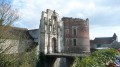
(6) Leave the return route on your right, turn left onto Rue de Meaux, ignore the path on the right and cross the Beuveronne. Turn left onto Rue de La Fontaine, pass the Church of Saint-Denis (on your left) and arrive at Grande Rue. Turn right, then at the junction cross at the pedestrian crossing. You’ll arrive at Place du Château de Nantouillet (a Renaissance castle dating from the 1520s).
(7) About a hundred metres further on, take Rue des Vignes diagonally to the right, ignore the path on the right and turn left, with the Ru du Rossignol on your right. Then follow Rue de la Rochelle, pass the Ferme de l’Abbaye and, after the left-hand bend, turn right along the D9 until you reach the former Collège de Juilly.
(8) Immediately afterwards, cross the Place du Collège, with the Église Saint-Étienne on your left. At the end, turn left onto Rue Allais and then right onto Rue Saint-Louis. At the end of this street, turn left onto Rue Pierre Loyer, then ignore two junctions until you reach Rue de La Louvière.
(9) Turn right onto it, then turn right again onto Rue du Tacot; cross one junction and, at the end, go straight on onto Chemin du Tacot. Carefully cross Rue des Prés Fleuris and take the path running alongside Rue de Meaux (D9) on your right. At the end of the path, you’ll see a cross on the right-hand side of the D9.
(10) Cross the main road carefully and take the wide path, with the Croix de la Sainte-Barbe on your right. Walk across the fields along the path leading to a Fork in the road and turn right, following the Ru de l’Abîme until you reach the next path on the left.
(11) Turn left onto the Chemin du Moulin, with the mill of the same name on your left. Cross La Beuveronne and turn left onto the next path. At the end, you’ll come back to the junction you passed on the way there, near the Nantouillet cemetery.
(6) Turn left, walk through a small wood and across the Champ du Puits, until you reach a crossroads.
(12) Turn right, then at the next track, turn right again, then left. You will reach the fork in the road you passed on the way there.
(5) Carry on straight ahead, leaving the path you took on the way there, and cross the stream. Walk through the Quartier de Vineuil, along Rue des Martyrs, then Rue de Vineuil, and pass the Grange aux Dîmes on your left. After a bend to the left and then to the right, carry on straight ahead until you reach the junction with Rue de Charny.
(13) Turn right onto this road; further on, just past a farm shed, turn left onto Chemin des Cerisiers, heading due south to the silos at Gué Brûlé.
(14) Turn right onto Rue des Gravières and, after the tarmac road, keep to the right and continue along a track. Follow a wall on your left until you reach the next junction.
(15) Turn left onto Rue du Transformateur, then carry on straight ahead along Rue de Charny. Pass Saint-Pierre de Charny Church on your left. Cross Rue de Charny, go past the next two junctions, cross Rue de Saint-Mesmes at the pedestrian crossing and, some 250 metres further on, you’ll reach the car park (S/E).

 Visorando Member
 Average
 Easy
Easy