View of Montfeulson from Agey

A lovely walk around Montfeulson between the picturesque villages of Agey and Rémilly-en-Montagne, which winds through the lush surrounding countryside, passing by cabottes (small stone huts) and the Chappe telegraph tower.

Details

n°108419564
Creation:
Last update:
Last review:
–
  • Walking
    Activity: Walking
  • ↔
    Distance: 5.07 mi
  • ◔
    Average duration: 3h 05 
  • ▲
    Difficulty: Easy

  • ⚐
    Back to start: Yes
  • ↗
    Ascent: + 853 ft
  • ↘
    Descent: - 853 ft

  • ▲
    Highest point: 1,841 ft
  • ▼
    Lowest point: 1,024 ft
  • ⚐ Country: France
  • ⚐ City: Agey (21410)
  • ⚑
    Start/End: N 47.284423° / E 4.765057°
  • ❏
    IGN map(s): Ref. 3022ET, 3023OT
  • Hour-by-hour weather

Description of the walk

Park in the car park in front of Agey Town Hall.

(S/E) With your back to the town hall, take Rue de Molphey towards the village centre.

(1) Turn right and take Chemin de la Ruelle de la Cure, which leads onto Rue de l’Église.

(2) Head down towards the River Sirène via the Chemin de la Ruelle de l’Abreuvoir.

(3) After crossing the river, turn right onto the path which leads back up to the Chemin des Ruelles (tarmac).

(4) Follow it to the right; it becomes Rue Basse until it meets the D108.

(5) At this junction, cross the Sirène via the road bridge and head up to the left, following the footpath to the top of the hill (where there is a wayside cross).

(6) Turn left onto the path leading up towards Rémilly-en-Montagne and follow it to the town hall.

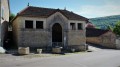
(7) At the town hall, turn right onto Rue des Carmes, which becomes Rue de l’Église, then turn right at the cemetery and continue to a wash house.

(8) Head up the track towards the plateau, keeping to the right, then climb towards the plateau through the woods to the Croix de Baumotte.

(9) Turn left onto the path that climbs across the field towards the high-voltage power line; once on the plateau, turn left, enter the stone enclosure and continue to the Chappe telegraph tower.

(10) Turn back towards the Croix de Baumotte.

(9) Turn left and take the path that runs along the plateau, heading down to Agey.

(11) At the junction with the Chemin de Damerone (tarmac road), turn left towards the wayside cross at the right-angled junction with the D9g (Rue de Baumotte), then turn right downhill towards the church and walk alongside the cemetery.

(12) At the church, turn left into Rue de la Croix de Molphey and head for the town hall car park (S/E).

Waypoints

  1. S/E : mi 0 - alt. 1,076 ft - Agey Town Hall car park
  2. 1 : mi 0.07 - alt. 1,086 ft - Junction with Ruelle de la Cure
  3. 2 : mi 0.12 - alt. 1,066 ft - Ruelle de l’Abreuvoir
  4. 3 : mi 0.22 - alt. 1,030 ft - Bridge
  5. 4 : mi 0.29 - alt. 1,060 ft - Chemin des Ruelles
  6. 5 : mi 0.51 - alt. 1,037 ft - Bridge
  7. 6 : mi 0.78 - alt. 1,198 ft - Junction – Cross
  8. 7 : mi 1.71 - alt. 1,181 ft - Rémilly-en-Montagne Town Hall
  9. 8 : mi 1.95 - alt. 1,293 ft - Washing house - Église Saint-Pierre-ès-Liens (Remilly-en-Montagne)
  10. 9 : mi 2.94 - alt. 1,673 ft - Croix de Baumotte
  11. 10 : mi 3.39 - alt. 1,837 ft - Chappe Telegraph Tower - La Montagne (Remilly)
  12. 11 : mi 4.7 - alt. 1,181 ft - Junction with Chemin de Damerone
  13. 12 : mi 4.97 - alt. 1,076 ft - Crossroads - Église Saint-Martin (Agey)
  14. S/E : mi 5.07 - alt. 1,076 ft - Agey Town Hall car park

Worth a visit

Chappe telegraph tower.

Cabottes.

The villages of Agey and Rémilly-en-Montagne.

Other walks in the area

For more walks, use our search engine .

The GPS track and description are the property of this route's author. Please do not copy them without permission.