Country:
 City:
City:


(S/E) On leaving the La Loubère car park, turn left and take the Route de Toulouse, towards Rieux-Volvestre.
(1) Take the first street on the right, the Chemin du Compagnon.
(2) At the end, take the tarmac path known as the Chemin des Hourquets on the right. When the tarmac ends, head straight up.
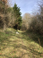
(3) When you reach an open area facing a fence, take the path on the left, following the fence and then the living hedge along the ridge path. Turn left to head downhill alongside a hedge on your left. Pass by the foot of a large oak tree. Head down the narrow, steep path to the right. Once you reach the woods, turn left. After descending this short wooded path, you’ll rejoin the tarmac Hourquets track. Take it on the right.
(2) At the junction, carry straight on until you reach the D627.
(4) Turn left. Follow the D627 to the roundabout, then turn right. Carry on straight ahead until you reach Rue Ramon de Versinis.
(5) Turn right, then immediately left onto Chemin du Bac de Titet.
(6) After the last house, turn right and follow the edge of the meadow. Head down to the banks of the Arize via the path through the woodland until you reach a clearing in the shade of the tall oak trees. Walk back up alongside the Arize on your right until you reach Chemin de Bonzoumet.
(7) Continue along the safety barrier and, at the bend, take a path opposite that runs alongside the Arize (head down again to the right to the water’s edge at the confluence of the Ruisseau de Darré le Bosc and the Ruisseau de Derrière le Bois, as shown on the map).
(8) Head slightly uphill and follow the path through the woodland until you reach the wide, carriageable track running alongside Chemin de Bonzoumet.
Carry on straight ahead to rejoin the D627, then turn right towards the car park (S/E).
 Tourist office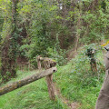
 Moderate
 Visorando Member