In the footsteps of Chateaubriand

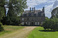
Chateaubriand enjoyed walking along the avenue of chestnut trees – now replanted with oaks – at the Château de la Sécardais (11). At that time, the château was owned by the Countess de la Celle de Châteaubourg, his sister.

Details

2052281
Creation:
Last update:
Last review:
  • Walking
    Activity: Walking
  • ↔
    Distance: 8.46 mi
  • ◔
    Average duration: 4h 10 
  • ▲
    Difficulty: Moderate

  • ⚐
    Back to start: Yes
  • ↗
    Ascent: + 289 ft
  • ↘
    Descent: - 295 ft

  • ▲
    Highest point: 308 ft
  • ▼
    Lowest point: 177 ft

Photos

Description of the walk

On the D102: Château de la Ville Ollivier car park.

(S/E) Follow the departmental road northwards (to the left as you leave the car park). Take the second road on the left and, immediately after, the small road on the right.

Red and white markings forthe GR® 39

After about a hundred metres, take the path on the right. Ignore a turn-off to the right and follow the path as it curves to the left. Continue along this path, keeping the Couesnon river below you at all times.

(1) Stay on theGR® whenit forks to the left.

No further markings

Then, at the fork in the road, let theGR® continue straight ahead and carry on to the right.

(2) Turn left onto the Equibreiz route (horseshoe-shaped) and head towards La Théaudière.
At the crossroads with a wayside cross on your right, carry on straight ahead and slightly to the right along the path leading to La Chaîne Rambours

(3) “La Chaîne Rambours” manor house (18th century). Follow the road to the right as it climbs northwards.
After the first house in Launay Binel, turn left onto the track, which very quickly becomes a footpath. Continue along this path.

(4) On the left, there is a possible shortcut to reach (7) directlysee below. Otherwise, turn right and rejoin the road.

(5) Follow the road to the left. At the junction, in the left-hand bend, carry on straight ahead towards Rabbat. Continue westwards until you reach the T-junction. Turn left to join the departmental road. You are now on aPR® route marked in yellow.

(6) Cross the D794 with care. Continue south-south-west to La Prévôtais.

(7) Turn left onto the dirt track, following the signposts. Carry on straight ahead at the first junction, then turn left onto the next track. After 150 m, turn right and continue along this track.

(8) Turn left onto a path through hedgerows until it joins another path.

Red and white signposts forthe GR®39

(9) Take theGR® on the left. Carry straight on at the junction. Do the same at Le Pâtis when you reach the departmental road.

(10) After Le Pâtis, turn onto the path on the right and continue until you meet another path.

(11) Manoir de la Sécardais (16th and17th centuries). Turn left and follow the path as it winds several times to reach another track (T-junction).

(12) Continue along the path to the left and head north-east.

(13) Turn left onto the road, then right after 50 metres, level with a bread oven.

No further signposting

Take a hairpin bend to the right. Cross the Seinière again. Continue to the district road, which you follow to the right to return to the car park, walking alongside the castle wall (S/E).

Waypoints

  1. S/E : mi 0 - alt. 187 ft - Château de la Ville Ollivier
  2. 1 : mi 0.97 - alt. 302 ft - Path on the left
  3. 2 : mi 1.63 - alt. 295 ft - On the left is the Equibreiz
  4. 3 : mi 2.47 - alt. 282 ft - “La Chaîne Rambourg” Manor House
  5. 4 : mi 3.1 - alt. 262 ft - Shortcut to ::8::
  6. 5 : mi 3.38 - alt. 285 ft - To the left, towards Rabbat
  7. 6 : mi 3.97 - alt. 299 ft - D794
  8. 7 : mi 4.6 - alt. 259 ft - Go straight on along the dirt track
  9. 8 : mi 5.39 - alt. 210 ft - Hedgerow path on the left
  10. 9 : mi 5.61 - alt. 220 ft - On the left, follow the GR39
  11. 10 : mi 6.35 - alt. 259 ft - Path on the right
  12. 11 : mi 6.83 - alt. 308 ft - Manoir de la Sécardais
  13. 12 : mi 7.3 - alt. 210 ft - To the left
  14. 13 : mi 7.57 - alt. 220 ft - Take the road to the left, then turn right after 50 metres
  15. S/E : mi 8.46 - alt. 187 ft - Château de la Ville Ollivier

Notes

Shortcut:

At (4), turn left. Cross the departmental road and continue straight ahead, keeping slightly to the right. At the end of the path, turn right and, when you reach the street, turn left. At the three-way junction, turn right to reach (7).

Alternative route for the return journey

For a route of approximately 12 km

At ::5: instead of turning left towards Rabbat: turn right, then turn left at the junction. Leave La Bouëxière on your right, pass through Theuré and continue towards the Moulin de Guyon, joining theGR®39which comes in from the right.
On the descent, before a hairpin bend, take the path that climbs to the left, then stay on it as it descends to reach the Passage des Intrépides. Cross the Couesnon and leave theGR® behind, continuing to the right.
Just before the houses, leave the road and follow the path on the right which descends and then runs alongside the river. Continue along this path, following the Couesnon upstream, until you reach the D102 county road.
Walk up it a little to the left, then cross over and take a small path on the right 50 metres further on. Take a sharp right-hand bend, cross the Couesnon via the footbridge, then continue almost directly opposite along the path overlooking the road.
Stay on this path, following the Ruisseau de la Motte stream below. After a bend to the right, cross the stream via the footbridge and, as you head uphill, cross the D102 to reach the starting point, which is directly opposite.

Worth a visit

Château de la Ville Olivier: owned by the municipality of Mézières-sur-Couesnon, this residence comprised eight flats until 20 August 2013, when part of a ceiling collapsed. Since then, the building has stood empty and access is prohibited.

Always be cautious and plan ahead when you're outdoors. Visorando and the author of this route cannot be held responsible for any accidents occurring on this route.

The GR® and PR® markings are the intellectual property of the Fédération Française de Randonnée Pédestre.

Reviews and comments

4 / 5
Based on 3 reviews

Reliability of the description
4.7 / 5
Ease of following the route
4.3 / 5
Route interest
3 / 5
patrickmontanes
patrickmontanes

Overall rating : 3 / 5

Date of your route : Oct 04, 2021
Reliability of the description : ★★★★☆ Good
Ease of following the route : ★★★★☆ Good
Route interest : ★☆☆☆☆ Very disappointing
Very busy route : No

A huge disappointment. A very monotonous route, with cornfields stretching as far as the eye can see. One hopes for a touch of romance on arrival at the Manoir de la Sécardais, where François René de Chateaubriand used to enjoy staying (hence the name of the route and the ultimate destination of the walk), but… not even a glimpse of the building’s slate roof to be seen, as the entire property is clearly occupied by a private farm. In the Mézières area, you’re far better off taking the walk through the Couesnon Valley.

Machine-translated

PierreMLS
PierreMLS

Overall rating : 4.3 / 5

Date of your route : Aug 29, 2021
Reliability of the description : ★★★★★ Very good
Ease of following the route : ★★★★★ Very good
Route interest : ★★★☆☆ Average
Very busy route : No

This route takes you through the livestock farms of the Couesnon plateau. It’s a chance to see herds and crops. The first half is a bit monotonous, with a lot of tarmac. The second half follows the GR39 and is more varied, shaded and lively. I’d recommend starting and finishing at WP1.

Machine-translated

deniaujclaude
deniaujclaude
• Edited:

Overall rating : 4.7 / 5

Date of your route : Jun 01, 2020
Reliability of the description : ★★★★★ Very good
Ease of following the route : ★★★★☆ Good
Route interest : ★★★★★ Very good
Very busy route : No

x

Machine-translated

Other walks in the area

For more walks, use our search engine .

The GPS track and description are the property of this route's author. Please do not copy them without permission.