


 Country:

 City:
City:


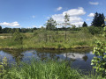
Park to the north of the village of Melay, along the D266.
(S/E) Head north on the D266 towards La Mer. At the first Fork in the road, turn right towards Les Berthey and Servance.
(1) At the next junction, head down the right-hand path towards Les Prary.
(2) At the Prary farm, turn left and pass between the pond and the house. Continue through the forest, ignoring the turn-offs to the left.
(3) After asecond pond, turn left and head uphill. Join a road and follow it to the left.
(4) Almost immediately afterwards, at the junction (cross), turn right.
(5) At the fork in the road, veer to the right. At first, the track is suitable for vehicles, then it becomes rougher, going up, down and winding between the ponds.
(6) At the fork in the road (about 4.5 km from the start), take the path on the left. Ride alongside a pond (on the right) then carry your bike to cross the spillway of another pond.
(7) Turn right after the spillway. Head north-east and ignore the turn-offs on the right.
(8) Join the VS3 mountain bike route and follow it to the right.
(9) Follow the road to the left. At Les Rouillons, turn right. At Le Frahy, turn right again.
(10) At the corner by a pond, take a path on the left. Join a road and first turn right then left to continue on the tarmac.
(11) At the junction, follow the D263 to the left (uphill). Turn right atthe first crossroads. At the T-junction, turn right again.
(12) At the Monthury junction, turn right (downhill) towards Lodge du Monthury. Pass this hamlet and continue along the path ( with stones on the descent).
(13) Head back up to the left, still following the VS3 route. Pass close to the picnic area and continue north.
(14) Return to the tarmac road at La Grande Rocholle.
(15) At the next junction, first turn left then right to follow a dirt track (leaving the signposted route). Head back down to the Étang de la Goutte Géhan and go round it on the right.
(16) Pass in front of the Auberge des 1000 Étangs and take the path on the right after the farm. At the Fork in the road at the edge of the forest, take the left-hand branch (on level ground).
(17) At the next junction, turn left and rejoin the VS3 route. Continue along the path, ignoring the offshoots to the right.
(18) At the peat bog, veer to the right. At the next junction (elevation 655), turn right and head towards the Goutte du Frêne.
(19) Follow the road to the left for about 200m. Take thefirst path on the right and head down through the fields (the markings are not very visible).
(20) Turn left to go round a pond on the left-hand side. Follow the VS3 mountain bike route, which leads onto a road: follow this to the left and pass through the hamlet of Le Grilloux.
(21) Turn right. At the next junction (elevation 632), turn right again. At the next crossroads, veer to the right.
(22) Leave the tarmac road just before Pré Guenée and take a dirt track. Ignore a turn-off to the right, then one to the left.
(23) At the Fork in the road, head slightly to the left. At the next junction, carry on straight ahead into the forest (Yellow Rectangle markings; ignore the mountain bike route branching off to the left). Keep heading south-west and ignore the side paths.
(24) Leave the Yellow Rectangle and head uphill to the right. Further on, turn left.
(25) At the T-junction, turn right. At a place called La Praie, continue along a tarmac road, which you should follow until you reach the departmental road.
(26) Cross the road and take the path leading up into the forest (marked VTT50). Keep heading west, then south-west.
(27) Turn left, then left again to join the D266. Follow this road to the left.
(28) At the entrance to the village of La Mer, take a track on the right and follow the VTT50 signposting. Turn left, then pass to the north of several ponds, heading west. Pass through the hamlet of La Marceline.
(29) At the fork in the road, veer left and leave the VTT signposting behind, heading towards Ecromagny as far as the Étang de Plate Pierre. Ride alongside the pond and turn left with the road.
(30) At a right-hand bend, leave the road and take a path that continues straight ahead. This path joins a forest track; take it to the left. Ride alongside a pond on the right, turn left then right to pass between two ponds.
(31) Just before La Champagne, turn left (mountain bike signpost 52).
(32) Leave the mountain bike route and turn right onto the Blue Ring marked path until you reach Vilory Farm. Then leave the marked path and take a track on the right. Pass close to a pond and join the D266.
Follow the road to the right for a few hundred metres to return to the starting point (S/E).

 Tourist office
 Easy
Easy 
 Difficult
 Visorando Member
