Serre Antoine - Saoû Forest

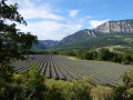
Sheltered by the imposing wall of the Saoû syncline, you will pass by the ruins of Pradas and enjoy unobstructed views of the Roubion valley.

Details

2308893
Creation:
Last update:
Last review:
  • Walking
    Activity: Walking
  • ↔
    Distance: 7.33 mi
  • ◔
    Average duration: 4h 35 
  • ▲
    Difficulty: Moderate

  • ⚐
    Back to start: Yes
  • ↗
    Ascent: + 1,417 ft
  • ↘
    Descent: - 1,421 ft

  • ▲
    Highest point: 2,717 ft
  • ▼
    Lowest point: 1,378 ft

Photos

Description of the walk

Car park located at the first crossroads on the way to the village of Mornans.

(S/E) From the car park, take the road eastwards for 200 metres. Just before Le Devès, turn left onto the path that goes around the buildings to the north. Continue eastwards to Mornans.

(1) Opposite the town hall, leave the road and take the wide stone path on the right. At Les Benoits, continue along the path on the left. Pass the house on the left and continue straight ahead. The path winds its way to the ruins of Le Vignal, where it turns left. Continue for about 80 metres.

(2) Turn right, then left into the shrubbery. The path turns right and heads south-east.

(3) Pass Le Bouvet on your right and continue straight ahead along the road. At the crossroads, take the road on the left, which is a hairpin bend. It climbs steeply and arrives at a flat area (DFCI water tank).

(4) Continue along the wide track to the right, leaving the right-hand fork behind. Turn left and cross the hamlet of Le Barry.

(5) Continue north on the wide track. It climbs and leads to a flat area at Serre Antoine.

(6) Leave the track and take the path that descends to the left. It runs alongside the ruins of the hamlet of Pradas and winds down the slope in wide bends.

(7) Ford the Eyzarette stream and climb up the opposite slope. Walk alongside the ruined hamlet of Bompard. The path widens and leads to the foot of the Cagnard house.

(8) Descend along the road, leaving the Jossaud road on your right, pass Tavau and arrive at La Cure (restored chapel).

(9) Keep following the road in the same direction, pass Les Gontards and return to the car park (S/E).

Waypoints

  1. S/E : mi 0 - alt. 1,385 ft - Parking at the first crossroads towards Mornans
  2. 1 : mi 0.64 - alt. 1,519 ft - Mornans
  3. 2 : mi 1.26 - alt. 1,713 ft - Fork in the road, to the right
  4. 3 : mi 1.51 - alt. 1,926 ft - Road, opposite
  5. 4 : mi 2.37 - alt. 2,411 ft - Wide track on the right
  6. 5 : mi 3.02 - alt. 2,425 ft - Le Barry
  7. 6 : mi 3.6 - alt. 2,717 ft - Serre Antoine
  8. 7 : mi 4.81 - alt. 1,909 ft - Eyzarette stream
  9. 8 : mi 5.41 - alt. 1,778 ft - Road near the Maison du Cagnard
  10. 9 : mi 6.18 - alt. 1,457 ft - La Cure, road opposite
  11. S/E : mi 7.33 - alt. 1,385 ft - Parking at the first crossroads towards Mornans

Notes

Please note: there is a ford on the route.Avoid hiking after periods of rain.

We strongly recommend that you take IGN map no. 3138OT with you. Bring sufficient food and water and wear suitable clothing for walking. Hikers must be self-sufficient, but professional guides are available if needed. Emergency numbers: 18 or 112.

Information from the Val de Drôme Tourist Office: 04 75 63 10 88 / valleedeladrome-tourisme.com

Worth a visit

HERITAGE - The Tower of Mornans.
The Tower of Mornans was most likely built in the 13th century during the Episcopal War between the Bishop of Die and the Count of Valentinois, to whom the Lord of Mornans was a vassal. Visible during the hike, it dominates the Roubion Valley. This 16-metre-high tower reflects the military strategy of the Romanesque period. Its cylindrical shape gave it the characteristics of an effective stronghold: resistant to the battering rams of attackers and offering a good view of the valley, it ensured greater effectiveness for the defenders stationed at its summit. Now in ruins, it has recently been reinforced so that it can continue to tower over the Roubion valley for a long time to come!
Please note: it is strictly forbidden to approach the Tour de Mornans due to the risk of collapse.

Reviews and comments

4.3 / 5
Based on 19 reviews

Reliability of the description
4.3 / 5
Ease of following the route
4.4 / 5
Route interest
4.4 / 5
Département de la Drôme

Hello,

if you encounter any issues with signposting or maintenance on your walking routes, please don’t hesitate to report them via the Suricate website or app: https://sentinelles.sportsdenature.fr/
It will be forwarded directly to the route manager, who can then take action.

Enjoy your hike!

Machine-translated

chiffonmimine
chiffonmimine

Overall rating : 4 / 5

Date of your route : Apr 27, 2026
Reliability of the description : ★★★☆☆ Average
Ease of following the route : ★★★★☆ Good
Route interest : ★★★★★ Very good
Very busy route : Yes

A well-equipped car park for walkers at the bottom of the village, with dry toilets, toilet paper and hand sanitiser. Well done to the municipality of Mornans. So we left the car park to head into the village; so far, so good. Things got a bit tricky at number 2 – luckily our phones beeped (3) because there were no signs to indicate where the path into the woods began. There were nine of us on this otherwise very pleasant trail, and we walked to Fonteresse for a picnic and back; the descent through the woodland was very, very pleasant. The rest of the walk was flawless, with plenty of lilacs in bloom in the middle of nowhere. Back to the cars.

Machine-translated

User 3939766

Overall rating : 4.3 / 5

Date of your route : Nov 03, 2025
Reliability of the description : ★★★★☆ Good
Ease of following the route : ★★★★☆ Good
Route interest : ★★★★★ Very good
Very busy route : No

A beautiful hike not far from Les Trois Becs and the Col de la Chaudière. Crossing the stream can sometimes be difficult after heavy rain.

Machine-translated

Fabjack
Fabjack

Overall rating : 4.7 / 5

Date of your route : Feb 24, 2025
Reliability of the description : ★★★★★ Very good
Ease of following the route : ★★★★★ Very good
Route interest : ★★★★☆ Good
Very busy route : No

A few kilometres on the road, not very interesting (start and end). The section through the woods is very pretty and pleasant, but slippery in wet weather.

Machine-translated

grimpeur26
grimpeur26

Overall rating : 5 / 5

Date of your route : Jan 18, 2025
Reliability of the description : ★★★★★ Very good
Ease of following the route : ★★★★★ Very good
Route interest : ★★★★★ Very good
Very busy route : No

Brilliant 👍

Machine-translated

Mpaput
Mpaput
• Edited:

Overall rating : 4 / 5

Date of your route : May 14, 2024
Reliability of the description : ★★★★☆ Good
Ease of following the route : ★★★★☆ Good
Route interest : ★★★★☆ Good
Very busy route : No

Hello

Very nice route, you have roads on both sides.
We followed the hike in the direction indicated.
Very nice view from 3 to 4, but the road is paved and the slope is very steep.
And from 5 to 8, there is a very steep descent through the woods with a fun finish.
a lovely 4 hour 50 minute hike with two adults, one 13-year-old and one 7-year-old.

Machine-translated

Département de la Drôme

Hello,

thank you for your detailed feedback. I will forward it to the route manager so that they can review the section that caused you problems. In future, please feel free to report any issues of this kind on the Suricate website or app: https://sentinelles.sportsdenature.fr/
The alert will be sent directly to the route manager, who will be able to take the necessary action to resolve the problem.

Enjoy your hike in Drôme!

Machine-translated

PANPI64
PANPI64

Overall rating : 3.7 / 5

Date of your route : May 11, 2024
Reliability of the description : ★★★★☆ Good
Ease of following the route : ★★★★☆ Good
Route interest : ★★★☆☆ Average
Very busy route : No

Hike completed on Friday, 10 May 2024. GPS and two smartwatches.
Positive points
The original car park has plenty of space.
A new fountain is available at the village exit.
There are some beautiful villas.
View of one of the three peaks.
Points for improvement
The link between points 2 and 3 is impossible to find. We used our GPS to reach them with some difficulty.
However, there is an old GR9 trail on the screen that is invisible in situ.
Overall, rather disappointing.

Thanks to the author of this hike, which could do with some improvement between points 2 and 3.

Machine-translated

FéeViviane
FéeViviane

Overall rating : 4.7 / 5

Date of your route : Feb 04, 2024
Reliability of the description : ★★★★★ Very good
Ease of following the route : ★★★★★ Very good
Route interest : ★★★★☆ Good
Very busy route : Yes

a bit too much tarmac road on the way back.

Machine-translated

Jean-Paul KERENFORT
Jean-Paul KERENFORT

Hello, following my report, I received the following message:
Hello,
Thank you for your report. The signage has been updated this year.
Thank you again for your commitment to preserving our hiking trails.
Julie Houwaer
on behalf of the Val de Drôme Community of Communes

Many thanks to the Val de Drôme Community of Communes and the volunteers for their work.

Machine-translated

Jean-Paul KERENFORT
Jean-Paul KERENFORT

Overall rating : 4.3 / 5

Date of your route : Feb 17, 2023
Reliability of the description : ★★★★★ Very good
Ease of following the route : ★★★☆☆ Average
Route interest : ★★★★★ Very good
Very busy route : No

Hello, we did this hike in very sunny weather and enjoyed the many views. There was a small problem with the route after point 2, where it was really difficult to find the path. Some signposting would be very useful. I have reported the problem on the Sentinelles Sport de Nature website.
Otherwise, it was a very pleasant hike.

Machine-translated

Département de la Drôme

Hello,

if you encounter any difficulties on a route, particularly due to poor signage or maintenance, please do not hesitate to report it on the website https://sentinelles.sportsdenature.fr/
There is also an app that allows you to report issues directly from the field.
The alert will be sent directly to the route manager, who will be able to take the necessary action to resolve the problem.

Enjoy your hike in Drôme!

Machine-translated

chriris
chriris

Overall rating : 4 / 5

Date of your route : Jun 02, 2022
Reliability of the description : ★★★★☆ Good
Ease of following the route : ★★★★☆ Good
Route interest : ★★★★☆ Good
Very busy route : No

Hello,

It was difficult to find the trail after point 2. I finally used my GPS to cut straight through the woods to reach point 3.

Machine-translated

Amauric alain
Amauric alain

Overall rating : 4.3 / 5

Date of your route : May 09, 2021
Reliability of the description : ★★★★☆ Good
Ease of following the route : ★★★★☆ Good
Route interest : ★★★★★ Very good
Very busy route : Yes

For my part, I do it backwards with a more aerial variation. From point 6, I follow your route to climb up to Fondoresse, where you can enjoy a magnificent panorama while you picnic. Then I take the GR towards Le Rastel hamlet, at the end of which I turn right towards La Tour to rejoin the route after crossing the Valla Blanc stream. After the town hall, take the path on the right that leads to Le Devès.
Another option at the start to avoid the tarmac road is to go to Devès and take the path on the left. At the next crossroads, take the path on the left which leads you to the crossroads of the tarmac road and the path to the ruins of Gontard.

Machine-translated

Département de la Drôme

Hello Berton,
thank you for your comment. Following several comments received about this circular, we have reversed the direction of rotation on the various paper promotional materials. It can therefore be done in either direction, depending on your preference!

Machine-translated

Other walks in the area

For more walks, use our search engine .

The GPS track and description are the property of this route's author. Please do not copy them without permission.