Country:

 City:
City:


(S/E) In the car park of the ‘Cave du Vieil Armand’, opposite the road, you’ll find the first information sign with general details. Head right until you reach the crossroads.
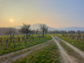
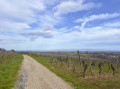
(1) Cross the road: you will then see a sign introducing you to the Alsatian vineyards. You’ll pass the first vines on your right, whilst the Brucker winery is on your left. Opposite the winery, take the path on the right. This path then veers slightly to the left, leading you through the middle of the vineyards. A few houses are visible further on.
(2) After the houses, at the fifth sign, turn left until you reach the next two signs and the Y-shaped Fork in the road.
(3) Continue along the path on the right. Two benches offer a chance to take in the view: Hartmannswiller, with its15th-century fortified cemetery and medieval castle (listed as Historic Monuments), lies below you; Berrwiller is to your right, with the Alsace Plain and the Black Forest in the background (in good weather). The path continues slightly uphill, almost in a straight line, to the ninth marker. The path then turns sharply right before leading you to the left, after a T-junction. You’ll reach the tenth signpost.
(4) Turn left to continue along the path, which will take you down a steep, grassy slope. Directly ahead, you can admire the Domaine d’Ollwiller and its château. The eleventh information panel will tell you more about them.
Then turn left, walking alongside the Domaine d’Ollwiller for three signposts. A 180° panorama unfolds before you: the Black Forest, the Alsace Plain, the villages of Hartmannswiller and Berrwiller, as well as the Domaine d’Ollwiller. Continue to the fourteenth signpost.
(5) Turn left up a steep hill. At the top of the hill, turn right. Continue straight on until you reach the ‘Y’-junction, where you’ll find benches and the final wine trail signpost.
(3) Return to the Cave du Vieil Armand, following the same route back as on the way there, until you reach (S/E).

 Visorando Member

 Difficult
  Very difficult