


 Country:

 City:
City:


The route starts at the sign opposite the town hall, on Place de l’Église. Follow the green markings featuring the dragonfly and leaf symbols.
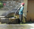
(S/E) Cross the square and follow the street to the right of the church (Rue de Hellé), then continue straight on. Pass the Malbrough (a statue-fountain of a young figure with water flowing through a flute) and carry on to the top of the street.
(1) At the top of Rue de la Belle Vue, take the path on the right.
(2) Just before the wayside cross, turn right onto the path below. Follow this path, known as the Chemin de l’Aulnay, to the end. At the junction, take the path on the left leading to the Bois Saint-Rémy.
(3) At the top of the path, take the track on the right. At the water tower, do not head back down to the right towards the village, but carry on straight ahead along the path for 400 metres (please note, a section of this path is damp and often muddy).
(4) At the junction towards Les Fromentières, take the path which descends to the right down a fairly steep slope, then continue straight on towards the village. As soon as you come to the end of the path, at the structure that acts as a stone trap, take the small tarmac road immediately to the left, then follow the street to the left where it joins, heading towards the forest.
(5) At Baransart, carry on straight ahead along the Chemin de Bagimont until you reach the concrete fortified house.
(6) Shortly after the fortified house, leave the Chemin de Bagimont and take the path on the left. Walk down to the pond. Walk round the pond clockwise, then take the same path back towards the fortified house. Retrace your steps to the start of the path.
(5) At this junction in Baransart, go round the wooden gate and take the path on the left. Pass close to the camping and picnic area and the fitness trail, then continue straight on. At the metal gate, continue along the same path, which curves to the right.
(7) At the Grigny junction, turn left and follow this path down for just over 400 metres. At the bottom, take the path on the right which leads onto a residential lane and follow Rue du Bouteny.
(8) At the end of Rue du Bouteny, before reaching Chemin des Épinettes, turn left and cross the bridge over the stream. After the bridge, turn right along the departmental road, then cross it. Walk for about 50 metres, then turn left onto the path that runs alongside the hedge and leads out behind the factory. Continue straight ahead along the path and follow Chemin des Longs Champs, which curves to the left.
(9) At the Sept Charmes junction, take the forest track on the right and follow it to the wooden hunting lodge. There, turn left and then immediately take the path on the right. Continue straight on along this path until you rejoin the forest track.
(10) At the end of the footpath, take the wide forest track on the right, then, shortly afterwards, take the first track on the left by the large oak tree. Then, after about 450 metres, take the track on the right. Keep going straight on; the track becomes a tarmac road which continues to the village.
(11) At the farm at the entrance to the village, cross the county road and continue along Ruelle de Cominay. This lane leads onto another county road; cross this to arrive opposite the cemetery. Continue down this street, then take the first lane on the left after the factory.
(12) Cross the bridge over the Goutelle and carry on straight ahead along Ruelle des Prés until you reach the church square (S/E).
 Local authority
 Easy
Easy 
 Visorando Member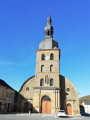
 Difficult
