The Pitch Kiln Trail in Merle-Leignec

Created by the “Trails and Local Heritage” committee of the Merle-Leignec local council, this walk allows you to discover various little gems of the landscape and heritage along its route: crosses, bachats, megaliths, a church and a listed cross.
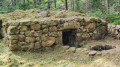
The trail’s main highlight is a working pitch kiln. A testament to the region’s former forestry activities, pitch was extracted using a specialised process to produce the pitch used for caulking boats. An information board is located on site. You’ll easily spot these little heritage treasures thanks to Plexiglas coats of arms in the town’s colours: yellow and green.

Details

39914943
Creation:
Last update:
Last review:
  • Walking
    Activity: Walking
  • ↔
    Distance: 3.65 mi
  • ◔
    Average duration: 2h 00 
  • ▲
    Difficulty: Easy

  • ⚐
    Back to start: Yes
  • ↗
    Ascent: + 338 ft
  • ↘
    Descent: - 338 ft

  • ▲
    Highest point: 3,166 ft
  • ▼
    Lowest point: 2,917 ft

Photos

Description of the walk

The walk starts from the car park below the village of Merle, where you can easily park.

The route is clearly signposted with ‘Four à poix’ signs, supplemented by yellow and green markings, the colours of the local council.

(S/E) From the car park below the village (on-site parking), head uphill to cross the main road and continue following the signs for “four à poix” and “lavoir”. On leaving the village, on the right, perched high above, a cross overlooks the village. Follow the yellow and green markings, then turn left towards Tardivier.

(1) In the hamlet, at the top of the village, turn right (signposted ‘four à poix’). A stone cross and a stone trough are on the right. Continue to the main road, follow it to the left for 200 m, then turn right onto the dirt track and walk for about 900 m.

(2) Cross a small tarmac road and carry on straight ahead to the pitch kiln. Then continue straight on to the road and take the path branching off to the right.

(3) Follow this track (signposted). After 500 m, there is a stone cross on the left. You’ll arrive at the hamlet of Montsoleil at the end of the track.

(4) Take the road on the right for 100 m, then take the first path on the right. About thirty metres further on, take the path on the right (signposted) and walk for about 700 m until you reach a crossroads.

(5) Leave the path, head left into the woods for 200 m, then turn right: you’ll pass the megaliths. Continue until you reach the tarmac road.

(6) Turn right, then left towards Le Mont. In the hamlet, there is a cross on the right and a viewpoint overlooking Montarcher and Estivareilles. Continue for 1 km, cross the bridge over the Gueuse and arrive at the D14.2.

(7) Turn left, then immediately right. Walk through the village (church and listed cross), then return to the road you came along and turn left to reach the car park (S/E).


Waypoints

  1. S/E : mi 0 - alt. 2,917 ft - Car park
  2. 1 : mi 0.37 - alt. 3,041 ft - Tardivier
  3. 2 : mi 1.24 - alt. 3,127 ft - Cross the road. Pass close to the - Four à Poix du Sapey
  4. 3 : mi 1.69 - alt. 3,133 ft - Road, GR®3 bypass
  5. 4 : mi 2.03 - alt. 3,064 ft - Montsoleil, road
  6. 5 : mi 2.52 - alt. 3,110 ft - Junction leading to the megaliths
  7. 6 : mi 2.69 - alt. 3,146 ft - The Mount
  8. 7 : mi 3.42 - alt. 2,969 ft - Merle, D14.2
  9. S/E : mi 3.65 - alt. 2,920 ft - Car park

Notes

There is a sign in the car park to help you find your bearings before setting off. It also features a QR code that allows you to download the walk onto your mobile phone and enjoy the benefits of Visorando.

Worth a visit

A special feature of this walk is that you’ll discover a working pitch kiln. As a testament to traditional forestry practices, pitch was extracted from coniferous trees using kilns and a specific process. This pitch was used to caulk boats.

Reviews and comments

4.5 / 5
Based on 2 reviews

Reliability of the description
4.5 / 5
Ease of following the route
4 / 5
Route interest
5 / 5
Commune de Merle-Leignec

Hello,
Thank you for your feedback.
It’s true that this section of the route is impassable, and the recent rain hasn’t helped matters, but we’re currently putting down stones and gravel to fill in the ruts and dry out this section.
We hope you’ll come back anyway to try out our other three routes.
The council team

Machine-translated

club randonnée monistrolien

Overall rating : 4.3 / 5

Date of your route : Apr 20, 2025
Reliability of the description : ★★★★☆ Good
Ease of following the route : ★★★★☆ Good
Route interest : ★★★★★ Very good
Very busy route : Yes

Unfortunately, the path was impassable – muddy with very deep, water-filled ruts – so we had to turn back
What a shame!!!!

Machine-translated

Commune de Merle-Leignec

Thank you for your very positive feedback, which is a great recognition of our work.
The council team

Machine-translated

milaz*0848
milaz*0848

Overall rating : 4.7 / 5

Date of your route : Nov 20, 2023
Reliability of the description : ★★★★★ Very good
Ease of following the route : ★★★★☆ Good
Route interest : ★★★★★ Very good
Very busy route : Yes

A very pleasant walk, very accessible for a group of pensioners. Well received by the participants

Machine-translated

Other walks in the area

For more walks, use our search engine .

The GPS track and description are the property of this route's author. Please do not copy them without permission.