Country:
 City:
City:


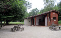
Park in the leisure area with the boules court on the outskirts of the village, towards Montagnac-sur-Auvigon.
(S/E) Start the walk by following the yellow and blue markings towards the Pont de Ninon, walking alongside a hedge. Climb up a slope and continue along the stream to the Route de Begoux.
(1) Cross the road and go round the house to the left along the road, then rejoin the path alongside the stream. Climb up onto the embankment, then turn right and then left at the Pont de Ninon. Continue along the edge of a hedge, following the stream ‘Le Malet’ for 600 metres until you reach a bridge crossing the stream.
(2) Cross the bridge, cross the road and take the stony path leading uphill opposite, signposted “Roc du diable”. When you reach the top of the hill, continue along the edge of the woodland, then enter the woodland opposite. Follow the path until you reach a road.
(3) Follow it to the right for about 300 metres, then, just before a house on the right, at the junction, take the path on the left, signposted “Circular Walk”, marked with blue signs for 300 metres. You’ll reach a clearing, opposite a large oak tree.
(4) Take the path leading down to the left and continue through the woods until you reach the Route des Bambous.
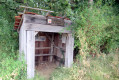
(5) Cross it and head up the path opposite, signposted “Sentier des mules”. At the next junction, take the path leading uphill to the right. When you reach the clearing, carry on straight ahead to the end of a vineyard (Buzet appellation), then go round it to the right, following the blue markings. Walk uphill between the vineyard and the woods, then turn left. At the edge of the woods, look out for the vineyard hut with information panels inside. Carry on between two vineyard plots. Pass another vineyard hut and continue straight ahead into the woodland. There are plum and persimmon (apple-like persimmons) trees on the right. Continue along the edge of a hedge, then a vineyard, until you reach a road, which you should follow to the right.
(6) At the hamlet known as “Claveté”, 50 metres past the house named “École de Montesquieu Jean Laffitte”, take a sharp left-hand bend onto the path running parallel to the road for about 50 metres, then head down the grassy path to the right, following the blue markings. Head downhill and enter the woods by crossing the bridge over the Ruisseau de la Gaule, then continue along the path, marked in blue. Pass in front of a pidgeon hunting hut and carry on until you reach the edge of the woods, then between two hedges. You’ll come to a fork in the path that you passed on the way out.
(4) Continue straight ahead, following the reverse route of the outward journey, until you reach (S/E).
 Visorando Member

 Easy
Easy