Mont Arpasse circular

A fairly easy circular with a variety of views over the Vésubie and Var valleys and far beyond...

Details

2846626
Creation:
Last update:
Last review:
  • Walking
    Activity: Walking
  • ↔
    Distance: 6.98 km
  • ◔
    Average duration: 3h 00 
  • ▲
    Difficulty: Moderate

  • ⚐
    Back to start: Yes
  • ↗
    Ascent: + 356 m
  • ↘
    Descent: - 351 m

  • ▲
    Highest point: 694 m
  • ▼
    Lowest point: 457 m

Photos

Description of the walk

Park on Chemin de la Cumba, just before the water treatment plant.

(S/E) Head towards the water treatment plant, then take the path on the left. Further up, you will reach a track that leads to a house. Make a slight first turn left then right, and you will quickly come to a junction.

(1) Leave the track on the left and continue straight ahead, passing through a barrier or gate, which you should remember to close behind you. Continue climbing until you reach marker 296.

(2) Turn onto the path on the left and get down to business with a slightly steep 100 m climb. The slope levels out after the electricity pylons. Turn right to reach the summit of Mont Arpasse, where there are two picnic tables.

(3) Continue a little further south to enjoy the view of the Var river flowing into the sea. Turn back and then veer right onto a path that avoids the track. Be careful, you are on a route used by mountain bikes, and even if there is plenty of room, don't get caught out.

(4) Return to the track but do not take it. Immediately turn right onto the path that cuts across several hairpin bends and joins the junction of the climb.

(1) Turn right and follow the outward route to return to the starting point (S/E).

Waypoints

  1. S/E : km 0 - alt. 486 m - Wastewater treatment plant
  2. 1 : km 1.39 - alt. 546 m - Trail junction
  3. 2 : km 2.59 - alt. 474 m - Marker 296 overlooking the - Canal de la Vésubie
  4. 3 : km 4.2 - alt. 691 m - Mont Arpasse
  5. 4 : km 5.26 - alt. 611 m - Track
  6. S/E : km 6.98 - alt. 486 m - Wastewater treatment plant

Notes

No particular orientation difficulties.

Reviews and comments

4.7 / 5
Based on 14 reviews

Reliability of the description
4.8 / 5
Ease of following the route
4.8 / 5
Route interest
4.6 / 5
sorrentoantony@gmail.com

Overall rating : 4.7 / 5

Date of your route : Jun 01, 2025
Reliability of the description : ★★★★★ Very good
Ease of following the route : ★★★★★ Very good
Route interest : ★★★★☆ Good
Very busy route : No

Short hike on 1 June.
Only two families encountered along the entire route.
However, we did encounter a deer and some donkeys, which was very pleasant.
There were a few sections near high-voltage power lines, but that didn't bother us.
The heat is already here, so... I think it's best to avoid this route during periods of intense heat for the time being.

Machine-translated

Alix06
Alix06

Overall rating : 5 / 5

Date of your route : Dec 08, 2024
Reliability of the description : ★★★★★ Very good
Ease of following the route : Not used / Not applicable
Route interest : ★★★★★ Very good
Very busy route : No

Hike completed in early December.
The views of Bonson with Mont Vial behind and the village of Levens with Mercantour in the background are splendid.
We were also greeted at Mont Arpasse by two very calm patous who simply approached us and stayed in our company. This is the first time I have ever encountered patous that are so calm and friendly.
As already mentioned, the start between markers 293 and 294 can be a little slippery as it is a paved path.

Machine-translated

levieuxrandonneur
levieuxrandonneur

Overall rating : 5 / 5

Date of your route : Jan 22, 2024
Reliability of the description : ★★★★★ Very good
Ease of following the route : ★★★★★ Very good
Route interest : ★★★★★ Very good
Very busy route : Yes

Beautiful view of the Tinée and Vesubie valleys.
Friendly Patou dogs: I took a nap with them 2 metres away (Papa Patou, mum and baby) but caution is still advised: stay calm and still.
Note: the first part of the route from the starting point (marker 292) to marker 294 (a relatively steep climb and then descent on rounded pebbles) can be tricky in wet weather and even impossible if icy.
On the way back to marker 294, you can take the track heading south (the track that leads to the summit), which takes you back to the starting point at a leisurely pace.

Machine-translated

GOGO
GOGO

Overall rating : 4.3 / 5

Date of your route : Jun 05, 2023
Reliability of the description : ★★★★★ Very good
Ease of following the route : ★★★★☆ Good
Route interest : ★★★★☆ Good
Very busy route : No

Everything has been said about this circuit, which we recommend. It's a shame that the Var is practically dry, which spoils the landscape somewhat.
Although warned by explanatory signs, we were surprised when we arrived on the plateau to be greeted by two Patou dogs.
No need to panic. We let them come to us and, once they were reassured of our intentions, we sat down at the picnic table. They stayed with us for the duration of our short break and watched us leave before heading back to the herd they were guarding.

Machine-translated

Romarin2006
Romarin2006

Overall rating : 5 / 5

Date of your route : Feb 18, 2022
Reliability of the description : ★★★★★ Very good
Ease of following the route : ★★★★★ Very good
Route interest : ★★★★★ Very good
Very busy route : No

A lovely little hike, with the advantage of being very close to Nice.
The only problem was finding the starting point, but Waze helped us out.

Machine-translated

Pierre et le renard
Pierre et le renard

Overall rating : 4.7 / 5

Date of your route : Nov 29, 2021
Reliability of the description : ★★★★★ Very good
Ease of following the route : ★★★★★ Very good
Route interest : ★★★★☆ Good
Very busy route : No

Nice hike, but I think there are better places to admire the Var or Vésubie valleys. In fact, the plateau at 700 m is less breathtaking than marker "2", which offers a view of both valleys at the same time.

Machine-translated

Daemons88
Daemons88
• Edited:

Overall rating : 5 / 5

Date of your route : Jul 03, 2021
Reliability of the description : ★★★★★ Very good
Ease of following the route : ★★★★★ Very good
Route interest : ★★★★★ Very good
Very busy route : No

A really nice hike, with some shaded areas at the beginning of the circular route. The arrival at the summit is magnificent, with a 360° view towards Bonson, Mercantour, the Var valley... A family of donkeys accompanied me on the trail above Vésubie 
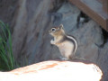
Apart from these three animals, I was alone throughout the entire hike.

Machine-translated

06Morgane
06Morgane

Overall rating : 5 / 5

Date of your route : May 09, 2021
Reliability of the description : ★★★★★ Very good
Ease of following the route : ★★★★★ Very good
Route interest : ★★★★★ Very good
Very busy route : No

Great hike, fantastic views at the summit.
An accessible and uncrowded hike worth repeating

Machine-translated

beauget
beauget

Overall rating : 5 / 5

Date of your route : Feb 19, 2021
Reliability of the description : ★★★★★ Very good
Ease of following the route : ★★★★★ Very good
Route interest : ★★★★★ Very good
Very busy route : No

This little hike was great. It's a shame it was grey but not cold, with a 360° view of the Mercantour mountains, the Var and Vésubie valleys and the sea. You can have a picnic there. I recommend it

Machine-translated

Edwige2711
Edwige2711
• Edited:

Overall rating : 5 / 5

Date of your route : Jun 17, 2020
Reliability of the description : ★★★★★ Very good
Ease of following the route : ★★★★★ Very good
Route interest : ★★★★★ Very good
Very busy route : No

I've done this hike many times, it's great to do.

Machine-translated

osiris130
osiris130 ★
• Edited:

Overall rating : 4.7 / 5

Date of your route : Jun 01, 2020
Reliability of the description : ★★★★★ Very good
Ease of following the route : ★★★★★ Very good
Route interest : ★★★★☆ Good
Very busy route : Yes

A lovely little hike near Nice.
No difficulty and beautiful panoramic views of the Vésubie Valley, the Mercantour peaks and the mouth of the Var.

Machine-translated

fttrando
fttrando
• Edited:

Overall rating : 4 / 5

Date of your route : May 18, 2020
Reliability of the description : ★★★★☆ Good
Ease of following the route : ★★★★☆ Good
Route interest : ★★★★☆ Good
Very busy route : No

At the summit, beautiful view of the Var valley and the surrounding hills.
Lovely encounter with an adorable and very friendly Patou dog.
A nice little hike to get back into it after two months of lockdown.

Machine-translated

LePoy
LePoy
• Edited:

Overall rating : 4.3 / 5

Date of your route : Mar 15, 2020
Reliability of the description : ★★★★☆ Good
Ease of following the route : ★★★★★ Very good
Route interest : ★★★★☆ Good

Hike completed in mid-March, in good weather. (16°C, light wind)
The hike is pleasant overall.
There are several beautiful viewpoints to enjoy. The Var Valley to the north at (2) and to the south at (3). Madonne d'Utelle at (3).
Violets, primroses and liverworts all along the path at the start. Please do not rake them so that everyone can enjoy them...
Some fairly steep sections, sometimes quite rugged. Walking shoes recommended despite the short distance (grip on slopes and strained ankles).

But...
You pass under high-voltage power lines several times, which spoil the landscape a little.
The start (and return) near the sewage treatment plant allows you to take a deep breath... of foul-smelling miasma.
The picnic tables on Mont Pelé are exposed to the wind. If it is windy and you plan to stop for a snack, it is better to take a small detour (10m) after point (2), continuing towards Plan du Var (pink dotted line on the map). You can sit at the side of the path and enjoy the view of Bonson and its rocky outcrop and the Var valley.

Description: There is no gate to close at stage (1). The only gate you will encounter is at the end of stage (4), just before returning to point (1).

Departure/parking: there is a large car park on the right after the fire station, just before the water treatment plant. There is no need to park on the side of the road at the entrance to the Chemin de la Cumba.

The return route from the picnic tables is not very well marked. Head north-west through the scrub.

Route: if you don't have a satnav, enter Levens, pass Le Grand Pré, 250m after the small roundabout at the end of Le Grand Pré, turn left towards "La Roquette" (not easy to see, slow down after Le Grand Pré) Route de la Roquette (you should see the Coopérative directly opposite you), pass the hairpin bend on the right, then (< 100m) take the first right (Avenue Charles David, towards La Môle), pass the petrol station and turn left onto Chemin de la Cumba.

Machine-translated

fredericmeunier
fredericmeunier
• Edited:

Overall rating : 4.3 / 5

Date of your route : Feb 18, 2020
Reliability of the description : ★★★★☆ Good
Ease of following the route : ★★★★☆ Good
Route interest : ★★★★★ Very good

The only slight downside was finding the sewage treatment plant, so we set off from the village swimming pool, passing through the small vegetable gardens on the hillside (going down the path) and the climbing wall.

Great day.

Machine-translated

pavani
pavani
• Edited:

hike not yet completed

Machine-translated

Other walks in the area

For more walks, use our search engine .

The GPS track and description are the property of this route's author. Please do not copy them without permission.