Martinacci

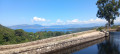
A pleasant circular route, with varied terrain and lovely views over the Taravo valley. There are a few rocky sections, and part of the descent is quite steep. The route alternates between forest tracks, meadows and scrubland paths. The section along the ridge takes you past a few granite boulders.

Details

60939176
Creation:
Last update:
Last review:
  • Walking
    Activity: Walking
  • ↔
    Distance: 1.92 mi
  • ◔
    Average duration: 1h 20 
  • ▲
    Difficulty: Moderate

  • ⚐
    Back to start: Yes
  • ↗
    Ascent: + 469 ft
  • ↘
    Descent: - 433 ft

  • ▲
    Highest point: 2,474 ft
  • ▼
    Lowest point: 2,031 ft

Description of the walk

Park at the side of the D55, at a place called Bocca di Chenova. A few minutes’ walk from the village of Marato.

(S/E) Take the path on the right, which runs more or less parallel to the road.

(1) Walk along the wall, heading uphill to the left, then enjoy the view over the rocks. Next, take the path leading down to the left and head to another viewpoint.

(2) Continue straight on, following a new wall.

(3) Cross the wall via a passage between large boulders. You’ll reach Punta di u Ballatoju.

(4) When you reach a clearing just beyond, continue downwards until you come out onto a forest track. Follow this, keeping in the same direction.

(5) Continue to the left to return to the car park (S/E).

Waypoints

  1. S/E : mi 0 - alt. 2,060 ft - D55
  2. 1 : mi 0.39 - alt. 2,136 ft - Wall, fork to the left
  3. 2 : mi 0.71 - alt. 2,156 ft - Granite boulders, viewpoint
  4. 3 : mi 0.89 - alt. 2,365 ft - Crossing the wall
  5. 4 : mi 1.22 - alt. 2,448 ft - Woodland clearing
  6. 5 : mi 1.83 - alt. 2,090 ft - Junction, turn left
  7. S/E : mi 1.92 - alt. 2,070 ft - Arrival

Reviews and comments

3.7 / 5
Based on 5 reviews

Reliability of the description
3.6 / 5
Ease of following the route
3.4 / 5
Route interest
4.2 / 5
Silana S.
Silana S.

I did it the other way round in the spring and, as I was climbing, came across a lovely rock outcrop on the right at an altitude of about 700 metres 8-)

Machine-translated

MarionVB
MarionVB

Overall rating : 4 / 5

Date of your route : Aug 19, 2026
Reliability of the description : ★★★★☆ Good
Ease of following the route : ★★★☆☆ Average
Route interest : ★★★★★ Very good
Very busy route : No

An easy walk on the way out, taking the path on the right. The climb is manageable up to the magnificent viewpoint over Ajaccio Bay.
However, the return route to complete the circular walk is poorly signposted; we found ourselves on a path that dropped sheer down a fairly steep slope, which wasn’t easy, and the rest of the walk wasn’t particularly interesting.
If I had the choice, I would have preferred to do a return trip via the same route.

Machine-translated

Silana S.
Silana S.

Overall rating : 4 / 5

Date of your route : Mar 02, 2026
Reliability of the description : ★★★★☆ Good
Ease of following the route : ★★★★☆ Good
Route interest : ★★★★☆ Good
Very busy route : No

Great... I'd like to do it again in the other direction (starting on the left) to have a picnic on the beautiful rocks on the way down, with a better view.

Machine-translated

bruno. m
bruno. m

Overall rating : 4 / 5

Date of your route : May 19, 2025
Reliability of the description : ★★★★☆ Good
Ease of following the route : ★★★★☆ Good
Route interest : ★★★★☆ Good
Very busy route : No

A short, easy walk (at least if you start on the right as indicated) which offers a stunning view of the Gulf of Ajaccio and the Taravo Valley. Just remember, in section 4, to make sure you climb over the wall that you started by walking alongside, otherwise you’ll lose the path.

Machine-translated

Memedidile
Memedidile

OK, thank you very much!

Machine-translated

Fred31
Fred31
• Edited:

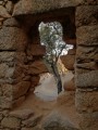
Martinacci is, in fact, the name of the place where the stone house is situated.
Indeed, in the depths of winter, the vegetation has reclaimed its territory and some sections are a little trickier.
Taking the route on the left, apart from the difficulty of finding some of the path entrances, also means having to tackle this long, steep slope (between 3 and 4) on the way up.

Machine-translated

Memedidile
Memedidile

Yes, we tried it both ways; we’d set off well along the path on the right but were surprised that Visorando made no mention of the ruined house, and as the path seemed little used (with grass growing right down the middle), we turned back to take the path on the left.
It was in the clear-cut area that we met the two young walkers, who’d persevered on the right-hand path but had found it very difficult (brambles and no clear track)!
As I’m also using Iphigénie, and with your photos, I think we might be able to manage this circular pattern
Do you know what the term ‘Martinacci’ refers to? I can’t find it on the IGN map.
Thank you

Machine-translated

Fred31
Fred31

Actually, I would have liked to be able to upload my photos. That would have made things easier.
And as for the start, it’s clearly marked that you should take the path furthest to the right.
It’s practically impossible to find your way if you go the other way.

Machine-translated

Memedidile
Memedidile

Overall rating : 2.3 / 5

Date of your route : Jan 27, 2025
Reliability of the description : ★★☆☆☆ Disappointing
Ease of following the route : ★★☆☆☆ Disappointing
Route interest : ★★★☆☆ Average
Very busy route : No

A short walk that’s certainly worth doing, although there’s some confusion about the direction of the walk at the start, followed by a section of path badly damaged by forestry work.
We met two other young walkers who’d given up after struggling for ages without managing to reach their destination.
We’ll go back there with the photos and a map posted by a hiker on Google Maps.

Machine-translated

FT Bouchard
FT Bouchard

Overall rating : 4.3 / 5

Date of your route : Nov 19, 2024
Reliability of the description : ★★★★☆ Good
Ease of following the route : ★★★★☆ Good
Route interest : ★★★★★ Very good
Very busy route : No

Here’s a lovely walk offering splendid views over the Gulf of Ajaccio and part of the Taravo Valley: the villages of Cognocoli and Pila Canale.

The route to the summit isn’t always easy to follow. The path disappears into the scrub.

A lovely walk

Machine-translated

Other walks in the area

For more walks, use our search engine .

The GPS track and description are the property of this route's author. Please do not copy them without permission.