Country:

 City:


The walk starts from the car park at the Jardin du Roi de Rome in Ventes-Saint-Rémy (Arboretum).
(S/E) Follow the path to the right of the Jardin du Roi de Rome (the Route du Talou). Stay on the Route Forestière de l’Église. At the five-way junction (elevation 195), take the small path to the left at a 90° angle between plots 265 and 262.
Carry on straight ahead, then, at the T-junction with the tarmac road, turn left and continue for about a hundred metres until you reach a fork.
(1) Follow the path to the right for 60 metres, then turn immediately left (to the right of plot 294) and do not head towards the Chapelle Saint-Étienne. At the end of the straight stretch, turn right.
(2) At the junction, follow the Route du Fond Saint-Étienne as indicated by the signpost – this is the second track from the right (to the left of plot 291).
At the five-way junction that follows, take the second road on the right, which goes uphill.
(3) At the junction 230 m further on, take the small track on the left. Follow this track for about 900 m.
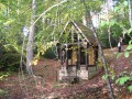
(4) At the junction, follow the path to the left at an acute angle (signposted ‘Chapelle Saint-Étienne’). Head downhill, pass in front of the chapel (take a moment to have a look at it) and continue to the main track at the bottom of the valley. Turn left and follow the track for about 500 metres to the junction.
(5) At the junction, turn onto the path on the right which climbs between plots 297 and 298 (marked route 10). Go to the end of the path and turn left towards the Hêtre Rudi (marked route 10).
(6) Pass Rudi’s Beech on your right, continue straight on to the end of the path and turn right onto the Route Forestière d’Haussez (marked route 10). Cross the Haussez junction 300 metres further on and continue straight ahead.
(7) At the junction, leave the forest and carry on straight ahead, then follow the main path (marked ‘Route du Talou’) for about 1,200 metres to reach Saint-Saëns. At the end of Chemin aux Galets, turn left onto Rue d’Haussez and follow it for 70 metres.
(8) Turn right onto the Sentier du Teurtre and follow it to Rue du Catelier.
(9) Turn left onto this street and follow it for about 500 m. On the right-hand side of the road, at the edge of the forest, take the signposted path that runs alongside the road.
After 80 m, pass the junction leading back down to the road and continue for 10 m.
(10) Turn right onto the path to enter the forest. Stay on the main path until the end, for about 2 km.
(11) At the junction with the Route Forestière de la Verrerie, turn left. When you reach the old glassworks, turn left and walk for 50 metres, passing the forester’s house on your right. Then take the first path on the right and walk for 60 metres.
(12) Then follow the track on the left, passing the Puits Merveilleux.
(13) Go round the well on the right and follow the path.
You’ll reach Route Forestière Bully. Turn right, then left after 50 metres to rejoin the nature trail, known as the Chemin des Écoliers. Follow it to the left. It goes round Camp Souverain. Walk past the farm and carry on straight ahead. After 300 metres, follow the path branching off to the left.
(14) Walk past the Carcahoux on your left. Leave the forest and head towards Les Ventes-Saint-Rémy. Continue straight on through the village and return to the starting point (S/E) after the junction with the D12, Route de Pommereval.

 Visorando Member
 Easy