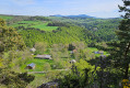
The Gagne hillsides from Bournac

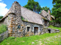
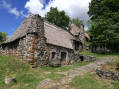
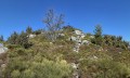
A short walk that circles the Bournac massif and offers views over much of the Gagne Gorges. The route is quite unspoilt, with many sections through woodland, making it very pleasant in hot weather. It makes a lovely addition to a visit to the hamlet of Bigorre, a village of thatched cottages situated nearby.

Details

1305089
Creation:
Last update:
Last review:
  • Walking
    Activity: Walking
  • ↔
    Distance: 3.33 mi
  • ◔
    Average duration: 2h 05 
  • ▲
    Difficulty: Moderate

  • ⚐
    Back to start: Yes
  • ↗
    Ascent: + 650 ft
  • ↘
    Descent: - 643 ft

  • ▲
    Highest point: 3,681 ft
  • ▼
    Lowest point: 3,068 ft

Description of the walk

Park near the wayside shrine at the entrance to the hamlet of Bournac.

(S/E) Let the main road branch off to the right towards Bigorre and take the small road on the left which crosses the hamlet and continues gently downhill through a landscape of hedgerows.

(1) At a three-way junction near the hamlet of La Teyssonnière, turn right and shortly afterwards you’ll pass a final house. Walk down through the meadows (enjoy the stunning view!) and at the end of the meadows you’ll reach a junction of forest tracks.

(2) Take the track on the right, which enters the woods and loses altitude quite quickly. Stay on the main track at all times, ignoring the paths that lead down to the left. The track levels out before continuing its descent to reach the lowest point (elevation 945 on the map).

(3) Head back up, staying on the same track, as the coniferous woodland gradually gives way to a beech forest.

(4) Ignore a path that descends steeply to the left and leads to Bigorre, and continue climbing straight ahead. The track widens and climbs through meadows. This brings you to the entrance to the hamlet of Bournac at a hairpin bend.

(5) Head down the road to the left and join the main road at a cross (pass). Turn right onto this road and, after about a hundred metres, you’ll reach the starting point (S/E).

Waypoints

  1. S/E : mi 0 - alt. 3,596 ft - Parking at the entrance to the hamlet of Bournac
  2. 1 : mi 1 - alt. 3,376 ft - La Teyssonnière
  3. 2 : mi 1.27 - alt. 3,271 ft - Junction of forest tracks overlooking the - Gagne (rivière)
  4. 3 : mi 2.05 - alt. 3,110 ft - Lowest point (945m)
  5. 4 : mi 2.65 - alt. 3,389 ft - Straight ahead uphill
  6. 5 : mi 3.13 - alt. 3,678 ft - Hairpin bend at the entrance to Bournac
  7. S/E : mi 3.33 - alt. 3,596 ft - Parking at the entrance to the hamlet of Bournac

Notes

The ground is sometimes quite stony, with steep slopes. Good walking shoes are therefore recommended.

Worth a visit

Don’t miss a visit to the hamlet of Bigorre, famous for its many thatched cottages, which has an eco-museum.

Reviews and comments

3.7 / 5
Based on 5 reviews

Reliability of the description
3.4 / 5
Ease of following the route
3.6 / 5
Route interest
4.2 / 5
laurent.carraro
laurent.carraro

I’m sorry to hear about your setbacks.
The route is indeed largely unmarked, and becomes quite wild after the last hamlet.
There’s a bit of road at the start, then it’s all track (so not even a strictly footpath).
It’s therefore fairly straightforward to follow, unless a forest track has been created once you’re in the woods, which can be a bit confusing.
Follow the GPS if you have trouble finding your way.

Machine-translated

Labricole
Labricole

Overall rating : 1.7 / 5

Date of your route : Oct 30, 2021
Reliability of the description : ★☆☆☆☆ Very disappointing
Ease of following the route : ★★★☆☆ Average
Route interest : ★☆☆☆☆ Very disappointing
Very busy route : No

Hello, be prepared for an unmarked route. Confusion is inevitable after the hamlet of La Teyssoneyre – not La Teyssoniere – at point 1. The suggested walk really does take you for a proper ramble!!! We found ourselves in the middle of the meadows with no real ‘trails’. After reading the description several times and turning back a few times, we gave up. In reality, two-thirds of the route was on roads. We were very disappointed by this ‘walk’ and by the clarity of the description.

Machine-translated

colomb
colomb

Overall rating : 3.7 / 5

Date of your route : Jun 22, 2020
Reliability of the description : ★★★☆☆ Average
Ease of following the route : ★★★☆☆ Average
Route interest : ★★★★★ Very good
Very busy route : No

We went at the start of June; it was lovely, even though we strayed off course – or even got lost – but despite that, we’d definitely do it again without hesitation.

Machine-translated

KI R.
KI R.

Overall rating : 5 / 5

Date of your route : Jun 03, 2019
Reliability of the description : ★★★★★ Very good
Ease of following the route : ★★★★★ Very good
Route interest : ★★★★★ Very good

A lovely walk and very accessible… you can even do it on a mountain bike without any trouble, apart from one fairly steep hill :=)

Machine-translated

rock
rock

Overall rating : 4 / 5

Date of your route : Nov 13, 2018
Reliability of the description : ★★★★☆ Good
Ease of following the route : ★★★☆☆ Average
Route interest : ★★★★★ Very good

The signposting is faulty. Or perhaps the signs disappeared before our walk…?

Machine-translated

laurent.carraro
laurent.carraro

That’s true… but fortunately there are still plenty of unmarked paths to explore

Machine-translated

rock
rock

Overall rating : 4.3 / 5

Date of your route : Nov 04, 2018
Reliability of the description : ★★★★☆ Good
Ease of following the route : ★★★★☆ Good
Route interest : ★★★★★ Very good

Signposting is rather lacking...

Machine-translated

Other walks in the area

For more walks, use our search engine .

The GPS track and description are the property of this route's author. Please do not copy them without permission.