Country:
 City:


Espinasse-Vozelle Stadium car park, Rue du Champ Colombier.
(S/E) Head towards the old wash house, passing behind the stadium changing rooms.
(1) Follow the tarmac road (D222) on the left up to the bend. (Caution: this is a busy road).
(2) Follow the grassy path opposite as it climbs. You’ll see the church with its distinctive bell tower; it is closed and, as of today (2026), cannot be visited.
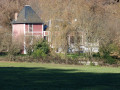
(3) Cross the road carefully and take Rue de l’Église. You can admire the beautiful buildings on the left: the vicarage and a stately home. Continue left along Route du Marais until you reach the first road on the right.
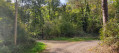
(4) Turn right onto Rue Madame de la Fayette and, as you round the bend, leave the tarmac and continue straight ahead along the track. Pass thefirst junction (the path on the right leading to the Vieux Château is blocked by a pile of earth), carry on straight ahead and follow the track on the right until you reach the junction.
(5) Turn right, passing in front of the Vieux Château, which was once the residence of Madame de la Fayette. It has been converted into farm buildings and is not open to visitors. Follow the road to the left to join a tarmac road.
(6) Turn left, then left again onto the Route des Varennes (D222). Continue for about 50 metres and turn right just before the industrial building to take a track.
(7) Turn left. The track opposite may be a shortcut leading to La Chaise. Continue until you reach a Fork in the road.
(8) Follow the first track on the right, pass in front of La Chaise – a castle converted into a farm which is not open to visitors – and head for the bridge over the railway line. Cross the bridge (be careful, it is narrow and there is heavy traffic).
(9) Carry on to the right along Rue de La Brosse (you’ll be on tarmac until you reach your destination). Walk down to the junction with Rue de Chabonne, turn right, and cross the bridge over the railway line. At the stadium, turn left to reach the car park (S/E).
 Visorando Member

 Moderate