The sheepfolds of the Contadour

Discover the dry stone sheepfolds to the west of the Lure mountains.

Details

28186
Creation:
Last update:
  • Walking
    Activity: Walking
  • ↔
    Distance: 7.50 mi
  • ◔
    Average duration: 6 hrs 
  • ▲
    Difficulty: Moderate

  • ⚐
    Back to start: Yes
  • ↗
    Ascent: + 912 ft
  • ↘
    Descent: - 912 ft

  • ▲
    Highest point: 4,692 ft
  • ▼
    Lowest point: 3,960 ft

Photos

Description of the walk

Park in the small car park just before the hamlet of Tinette (S).

Continue down the road to Tinette; this is the GRP footpath (Grande Randonnée de Pays – Long Regional Hike) that goes around the Lure mountains. In Tinette (1) the road becomes a track and then a path.
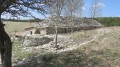
Keep following the path until you reach the restored sheepfold of Jas des Terres de Roux (2).

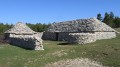
Keep following the GRP path due north for about 1km until you reach a crossing at right-angles that is not on the IGN map. Take the wide track to the right (3) (no waymarks) and keep going along the plateau towards the ruins of the Fraches sheepfold (4).

Turn left and head due north. The path will take you past another sheepfold that is also in ruins and then reaches the Jas des Agneaux sheepfold (5), which is 5 minutes from the GRP footpath.
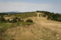
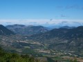
Join the GRP footpath and stay on it until you reach the high point marked by a large cairn (6).

Head due south down the path to the right with the yellow waymarks. Keep going until you reach a large junction where you can make a detour to the left to see the last sheepfold (7).

Come back to the crossroads, turn left down the path, and then turn right at the next crossing. Walk down the edge of the forest until you reach the crossing with the DFCI (forest fire prevention) water tank (8). Turn left onto the path which leads back to the car park.

Waypoints

  1. S/E : mi 0 - alt. 3,960 ft
  2. 1 : mi 0.45 - alt. 4,003 ft - Tinette
  3. 2 : mi 1.42 - alt. 4,209 ft - Bergerie du Jas des Terres de Roux
  4. 3 : mi 2.43 - alt. 4,268 ft - Crossroads to Les Fraches
  5. 4 : mi 2.9 - alt. 4,321 ft - Les Fraches sheepfold
  6. 5 : mi 3.7 - alt. 4,478 ft - Jas des Agneaux sheepfold
  7. 6 : mi 4.19 - alt. 4,656 ft - Cairn
  8. 7 : mi 6 - alt. 4,354 ft - Last sheepfold
  9. 8 : mi 6.5 - alt. 4,072 ft - Crossroads with the DFCI water tank
  10. S/E : mi 7.5 - alt. 3,960 ft

Notes

There are many shelters in the area, all in the form of sheepfolds.
The sheepfold of Terre de Roux has been restored and is now classified as a historic monument. It is well worth the visit, being careful to respect the site, to admire the remarkable stack of stones forming the roof. A pure masterpiece.
The highest sheepfold, that of Jas des Agneaux, has a special history: it was here that Jean Giono shot them film Crésus, with Fernandel in the lead role.

Worth a visit

Les villages perchés de Simiane-la-Rotonde et[Banon|http://www.village-banon.fr/fr/}.
Les Gorges d'Oppedette.
Le Colorado de Rustrel.
Forcalquier et Apt.

Other walks in the area

For more walks, use our search engine .

The GPS track and description are the property of this route's author. Please do not copy them without permission.