The Baisses de la Juberne circular walk

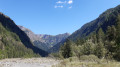
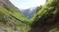
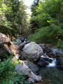
A circular walk on the north-facing side of the Séveraissette Valley in Molines-en-Champsaur. Almost entirely shaded along its entire route, this walk is particularly suitable for hot summer days. After a gentle warm-up along the Torrent de Muande, the climb becomes steep as you reach the highest point, before descending gently along the circular path which crosses several small streams beneath the Baisses de la Juberne.

Details

48928414
Creation:
Last update:
Last review:
  • Walking
    Activity: Walking
  • ↔
    Distance: 7.21 mi
  • ◔
    Average duration: 5h 35 
  • ▲
    Difficulty: Moderate

  • ⚐
    Back to start: Yes
  • ↗
    Ascent: + 2,638 ft
  • ↘
    Descent: - 2,641 ft

  • ▲
    Highest point: 6,237 ft
  • ▼
    Lowest point: 4,009 ft

Description of the walk

From Saint-Bonnet-en-Champsaur, take the D23, then the D123 towards La Motte-en-Champsaur. Drive through the village and take the road to Molines-en-Champsaur. After about 4 km on a narrow road – which may occasionally be temporarily blocked by flooding from the Torrent des Pins – you will reach the car park at an altitude of 1,220 metres.
Park in the large car park on the right, about 500 m before the entrance to the village.

(S/E) From the car park, take the path on the right, following the sign for “Départ des randonnées” (yellow markings). Walk upstream along the Séveraissette, then the Torrent de Peyron Roux, as far as the village.

(1) Opposite the sign, turn right onto the forest track, heading south-east towards the hamlet of Le Roy.

(2) Leave the track and take the path on the right down to the pebbly bed of the Torrent de la Muande. Be careful: the path becomes faint, but the ford is marked by a signpost. Ford the torrent and continue south-west, following the few cairns along the way. Make your way to the rampart walk (signpost), partly by sight.

(3) Climb the path on the left, heading south then south-east. Cross several streams until you reach a junction.

(4) Turn onto the path on the right, heading north-west, to climb towards the Col du Cendrié. The path winds in steep hairpin bends, then crosses a torrent before more hairpin bends. Be careful: this path is less well signposted. Further up, it cuts across towards the south-east and eventually emerges from the woods into a large meadow. You’ll reach a junction at a cairn.

(5) Continue straight ahead, heading south-east, towards Le Roy, leaving the ascent to the Col du Cendrié on your right. Continue the descent along the mountainside to the next junction to rejoin the circular path.

(6) Turn left, heading north-west, ignoring the path on the right which climbs towards the Cabane de Suzaire and the Col de l’Escalier. Descend diagonally through the forest, crossing several streams until you reach the junction you passed on the way up.

(4) Continue straight on along the circular path, heading north-west, to descend until you are walking alongside the pebble-strewn bed of the Torrent de la Muande. Be careful: the path becomes less distinct as you approach the torrent’s bed, but the ford is marked by a signpost.

(3) Ford the stream, heading north-east, following the few cairns along the way. Make your way – partly by sight – to the Route Forestière du Roy.

(2) Follow the track back up to the village of Molines.

(1) Take the small path on the left, heading in the opposite direction, to reach the car park (S/E).

Waypoints

  1. S/E : mi 0 - alt. 4,012 ft - Molines-en-Champsaur car park - Séveraissette (torrent) - Affluent du Drac
  2. 1 : mi 0.34 - alt. 4,068 ft - Junction with the Route forestière du Roy
  3. 2 : mi 0.71 - alt. 4,117 ft - Crossroads; descent towards the ford - Muande (torrent) - Affluent de la Séveraissette
  4. 3 : mi 0.95 - alt. 4,131 ft - Ford - Muande (torrent) - Affluent de la Séveraissette
  5. 4 : mi 1.57 - alt. 4,396 ft - Baisses de la Juberne junction – Col du Cendrié
  6. 5 : mi 3.33 - alt. 6,201 ft - La Juberne junction (elevation 1,891)
  7. 6 : mi 4.36 - alt. 5,607 ft - Junction between the Cabane de Suzaire and the Col du Cendrié - Creux de l'Aigue (torrent) - Affluent de la Muande
  8. S/E : mi 7.21 - alt. 4,012 ft - Molines-en-Champsaur car park

Notes

Fountain in the village of Molines (1). Several streams along the route.

Several fords can become tricky after heavy rain or during the snowmelt.

In the village of Molines-en-Champsaur: meals are available at the Auberge Gaillard. Its garden, dotted with sun loungers and hammocks, offers a refreshing break after the walk!
As well as its renowned cuisine, the inn offers six guest rooms for those wishing to extend their stay in Molines-en-Champsaur. Whether for a meal or an overnight stay, booking is strongly recommended. Tel. 06 09 30 07 47 or 04 92 43 40 99 auberge-gaillard.fr

The Écrins Massif is an exceptional area, open to all, boasting natural, cultural and scenic heritage of rare beauty. To protect these treasures, the heart of the park is marked by blue-white-red flags, and visitors must adhere to the regulations in force there. Please familiarise yourself with these regulations when planning your hike to help preserve this shared heritage, at https://www.ecrins-parcnational.fr

Worth a visit

Where the torrents of Peyron Roux and La Muande join their crystal-clear waters, in the shadow of Vieux Chaillol, Molines-en-Champsaur enjoys a natural setting of great beauty. The village’s name is linked to the old mills that once stood there. Before the war, there were two families in Londonnière, two in Les Boyers, five in Le Roy, and five in Le Sellon (hamlets of Molines). Mass emigration to the United States, the two world wars of the 20th century and violent flooding of the torrents gradually depopulated the area, leaving the hamlets of Le Roy (at the confluence of the Riou-Beyrou and the Muande torrent), Sellon (which was the last to be abandoned), Londonnière and Les Boyers (well situated on the right bank, near Le Roy) at the mercy of the ravages of time. However, a few permanent residents still live in the village of Molines.
This gateway to the Écrins National Park serves as the starting point for numerous hikes.

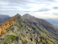
Les Baisses de la Juberne refers to an area of rocky outcrops and steep slopes. Renowned for its botanical diversity, it is home in particular to the Austrian Pleurospermum (Pleurospermum austriacum), a large umbellifer that is very rare in France, which flourishes at the foot of these rocky escarpments.

The hamletof ‘Le Roy’ was known as ‘La Muande’ until around 1780. There are numerous ‘muandes’ in Champsaur-Valgaudemar; these are high-altitude valleys where herds were grazed and where shepherds had to spend the summer in makeshift shelters. These “muandes” gave rise to torrents which then flowed down into the valleys. However, legend has it that Louis XVI exempted the hamlet’s inhabitants from taxes after it was ravaged by floodwaters. In gratitude, they are said to have renamed their village in his honour.

The Séveraissette valley is dominated by the Vieux Chaillol (3,163 m), the iconic peak of the Champsaur and the highest point of the southern Écrins Massif. The shaded slopes traversed by this walk contrast with the mountain pastures and more open slopes visible on the other side of the valley.

Other walks in the area

For more walks, use our search engine .

The GPS track and description are the property of this route's author. Please do not copy them without permission.