


 Country:

 City:
City:


Park in the car park to the left of the lodge (start of the Chamina ‘Le Puy d’Alou’ route,PR®® 28).
(S/E) Take the road that runs past the lodge towards the cemetery.
(1) Take the first path on the right which runs along the Serre plateau to the hamlet of Cluchat.
(2) Continue to the right through the hamlet and walk past the wash houses on your left. Stay on the path opposite, which descends towards the bottom of the valley (south-east).
(3) At the bottom of the valley, take the path on the left and stay on this path for 600 m.
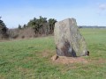
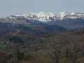
(4) At the crossroads, turn right, following thePR®® 28 to the road. First turn right then left, and take the wide track (magnificent view of the Sancy massif). Continue along the track to the fork in the path with a sign for the menhir on the right and the dolmen on the left.
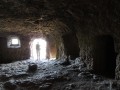
(5) Carry on straight ahead for 100 m. At the next junction, leave the track that descends to the right and take the path opposite towards ‘Grottes de Châteauneuf’ (views of Murol Castle and the Sancy massif). A steep but short climb up to the Puy de Châteauneuf. You’ll reach the Grottes de Châteauneuf.
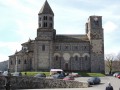
(6) Turn back for a few metres, then turn right and begin thefirst part of the descent towards Saint-Nectaire, which is a little tricky. On reaching Saint-Nectaire, walk round the church (well worth a visit as it is one of the major Romanesque churches in Auvergne) then head down to the left to the entrance to the Cornadore Caves on the D996.
(7) Cross the bridge opposite the entrance to the caves. Then take the road that climbs to the left for 400 m (follow theGR®®30–PR®® 26 towards Lac Chambon – Murol), turn right and then right again, following theGR®®, until you reach a crossroads.
(8) Stay on the path on the right – this is theGR®®30– until you reach the D996.
(9) Turn left onto it for about 150 m, then turn right onto theGR®® and continue to the hamlet of Chautignat. Magnificent views of Murol Castle and the Sancy massif.
(10) In the hamlet, leave theGR®®30on your left and carry on straight ahead towards Lac Chambon. Take the road that climbs to the right, pass the fountain (on your right), then stay on the road until you reach the D5.
(11) Cross it and take the track leading uphill opposite for about 250 m.
After the water tower, take the path on the left. This runs along the northern edge of the Dent du Marais volcanic cirque for about 400 m.
Ignore the path (G30) that branches off to the left along the western edge of the cirque and carry on straight ahead towards Le Vernet-Sainte-Marguerite.
(12) At the Croix de Barbat junction, carry on to the right until you reach the village of Beaune-le-Froid. Cross the stream, reach the fountain and take the road that climbs to the left, heading north, until you reach the village outskirts.
(13) Turn left, follow the road for about 200 metres, then, at the crossroads with the cross, turn right onto the track leading uphill. Carry on straight ahead, heading north-west, for about 1,500 metres.
(14) At the end of the track, turn left for 40 m, then turn right and head for the ‘Bois de Saignes (elevation 1224)’ junction. Take the right-hand track towards Vernet-Sainte-Marguerite. Follow this track through the Bois de Saignes for just under 3 kilometres.
(15) Please take care from this point onwards (there are numerous junctions within short distances, so check the map carefully). At this large junction, the track curves to the right; do not follow it, but take the path on the left instead. Carry on for about 70 to 80 metres; when you reach another junction of narrow paths, take the one on the right for about 40 metres until the next junction. Take the path that branches off to the right as it curves and carry on straight ahead. After about 300 m, you’ll reach another junction; carry on straight ahead (do not take the signposted path on the left which leads to Mareuge). At the end of the path, turn right to join the D5 road and turn left. Follow the D5 for 250 m until you reach the wayside cross and cross over.
(16) At the wayside cross, there are two paths: one heading south, the other east.
Take the one heading east for about 600 m, turn right and carry on straight ahead to the starting point (S/E).

 Visorando Member
 Moderate

