The Trou de Fer from Hell-Bourg and a circular tour through the Belouve Forest

A lovely hike starting from the magnificent village of Hell-Bourg to reach the impressive Trou de Fer site, and a circular route to explore the Bélouve Primeval Forest.

Details

1602281
Creation:
Last update:
Last review:
  • Walking
    Activity: Walking
  • ↔
    Distance: 19.46 km
  • ◔
    Average duration: 8h 15 
  • ▲
    Difficulty: Difficult

  • ⚐
    Back to start: Yes
  • ↗
    Ascent: + 955 m
  • ↘
    Descent: - 956 m

  • ▲
    Highest point: 1,608 m
  • ▼
    Lowest point: 959 m

Photos

Description of the walk

Start from the picnic area in front of the forest house.

(S/E) Follow the road on the left for 150m to reach the start ofthe GR® R1, where you can also park.
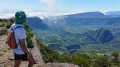
Take theGR® to the right, heading towards the Belouve Lodge. It starts as a concrete path that quickly turns into a gently sloping trail at first, then climbs increasingly steeply in switchbacks. Several wayside shrines along the way and beautiful views of Hell-Bourg and the Cirque de Salazie.

(1) The climb ends with concrete steps and the remains of an old cable car. A short descent into a ravine, followed by a climb up the other side, leads to the Bélouve lodge site.
Magnificent views of the Cirque de Salazie, a water tap and picnic tables.

(2) Take the path eastwards for about fifty metres until you come to a sign with a hiking map and the start of the path marked "Trou de Fer". The path, which is very muddy, winds through the forest. Once you reach the Fleurs Jaunes forest road, follow it to the left for a good hundred metres, then leave it to take the Trou du Fer path on the right. Join the bridle path, a wide stony track.

(3) Follow the bridle path to the left towards the north-east.

(4) After 850m, the Trou de Fer path branching off to the left was closed for renovation. We therefore had to continue along the bridle path for 1.3km, until the junction with the École Normale path.

(5) Take this path to the left, heading north, to reach the Trou de Fer viewpoint.

(6) Return along the same path to the junction with the bridle path.

(5) Continue straight on southwards towards Plateau Cochons, ignoring the path that branches off to the left 80m further on.

(7) The path runs alongside a depression in the forest, the Grande Mare, which was completely dry in early November. Continue to the junction with a forest track.

(8) Follow the track southwards towards Coteau Monique and the Bébour-Bélouve forest road.

(9) Pass a picnic area. At the end of the forest track, continue along the path heading south-west, still towards the forest road.

(10) When you reach the Bébour-Bélouve road, follow it to the right for about 100m, then turn left onto the Vierge track, which is closed off by a barrier.

(11) After 250m, take the path on the right, signposted “Lodge de Belouve”. Follow it until you rejoin the La Vierge forest track.

(12) Do not take the forest track opposite, but head left instead. After a second hairpin bend, there is a viewpoint overlooking the forest.

(13) Shortly after the viewpoint, take the Tamarinaie path on the right to reach the rim of the Cirque de Salazie.

(14) Turn onto the path on the right towards the Belouve Lodge, following the edge of the rim with lovely views of the Cirque de Salazie in places.

(15) On reaching the pylon, a viewpoint offers a stunning view of the cirque. Then take the track back to the Belouve Lodge.

(2) Then take the same path as on the way up to descend to Hell-Bourg and the forest house (S/E).

Waypoints

  1. S/E : km 0 - alt. 972 m - Picnic area in front of the forest house
  2. 1 : km 2.98 - alt. 1,467 m - Old cableway
  3. 2 : km 3.16 - alt. 1,495 m - Belouve Lodge – junction of the circular route
  4. 3 : km 4.2 - alt. 1,514 m - Riding track
  5. 4 : km 5.04 - alt. 1,476 m - Trou de Fer trail
  6. 5 : km 6.39 - alt. 1,414 m - École Normale trail
  7. 6 : km 7.21 - alt. 1,358 m - Trou de Fer viewpoint
  8. 7 : km 8.87 - alt. 1,407 m - Grande Mare
  9. 8 : km 9.87 - alt. 1,459 m - Les Mares forest track
  10. 9 : km 10.63 - alt. 1,475 m - Picnic area
  11. 10 : km 12.26 - alt. 1,568 m - Route de Bébour-Bélouve
  12. 11 : km 12.61 - alt. 1,587 m - Marked trail “Lodge de Belouve”
  13. 12 : km 13.56 - alt. 1,540 m - Sentier de la Vierge
  14. 13 : km 14.12 - alt. 1,583 m - Tamarinaie Trail
  15. 14 : km 14.65 - alt. 1,608 m - Volcano refuge trail
  16. 15 : km 15.39 - alt. 1,560 m - Kiosk and pylon
  17. S/E : km 19.46 - alt. 971 m - Picnic area in front of the forest house

Notes

Please note: the forest paths can sometimes be very muddy, despite the sections fitted with boardwalks.
It is best to set off very early in the morning to reach the Trou de Fer viewpoint before the clouds roll in.
Water point at the Belouve Lodge.

Worth a visit

The museum area in a building to the left of the lodge traces the history of the "Paul Charly" forest cableway.
Visit to the village of Hell-Bourg.

Always be cautious and plan ahead when you're outdoors. Visorando and the author of this route cannot be held responsible for any accidents occurring on this route.

The GR® and PR® markings are the intellectual property of the Fédération Française de Randonnée Pédestre.

Reviews and comments

4.7 / 5
Based on 4 reviews

Reliability of the description
4 / 5
Ease of following the route
5 / 5
Route interest
5 / 5
Antheaume
Antheaume

Overall rating : 4.7 / 5

Date of your route : Mar 13, 2023
Reliability of the description : ★★★★☆ Good
Ease of following the route : ★★★★★ Very good
Route interest : ★★★★★ Very good
Very busy route : Yes

A lovely walk to do early in the morning.
Start (and finish) at the Hell-Bourg town hall annexe, heading up to the Belouve lodge. The climb to the lodge is 3km with 550m of elevation gain, over terrain that is technical and slippery in wet weather.
The second section (from the Belouve lodge to Trou de Fer) is easier, especially if you take the bridle path (which is less muddy).
The view on arrival at Trou de Fer is magnificent. We were lucky as the view was clear and there were hardly any clouds.
We returned via the same route as on the way there.
Please note that the circular route through the Belouve forest is closed. You cannot therefore complete the suggested 20 km route, but at best 15.5 km with a total elevation gain of 900 m. Allow 5 hours for the round trip, excluding breaks.

Machine-translated

j.julius
j.julius

Overall rating : 4.3 / 5

Date of your route : Oct 03, 2022
Reliability of the description : ★★★☆☆ Average
Ease of following the route : ★★★★★ Very good
Route interest : ★★★★★ Very good
Very busy route : Yes

The path between points 5 and 10 (Plateau Citrons and Plateau Cochons) is closed and effectively impassable (I turned back). The path between points 12 and 14 is very muddy. Given the current state of the paths, I recommend only going as far as point 6. The views from the pile (point 13) and the antenna (point 15) offer nothing more than those taken at the Belouve lodge.
Highlights: beautiful views over the Cirque de Salazie and the Trou de Fer, lovely primeval forest, Belouve lodge.

Machine-translated

Orando974
Orando974 ★

Overall rating : 5 / 5

Date of your route : Jan 15, 2020
Reliability of the description : Not used / Not applicable
Ease of following the route : Not used / Not applicable
Route interest : ★★★★★ Very good

We only did the ascent to Bélouve: a superb hike, culminating in a breathtaking view of the Cirque de Salazie. The climb is manageable despite the 580-metre elevation gain. It is rarely very steep, although the final few metres are a little steeper than the rest of the route. In fact, the climb features several flat sections of varying lengths. Much of this climb is in the shade. Worth noting: several springs dot the path during the wet season in the first third of the climb. In the dry season, I doubt this is the case.

Machine-translated

Mariala
Mariala

Overall rating : 5 / 5

Date of your route : Nov 28, 2019
Reliability of the description : ★★★★★ Very good
Ease of following the route : ★★★★★ Very good
Route interest : ★★★★★ Very good

Hello
We decided against tackling the climb from Hell-Bourg and simply started the circular route from point no. 10, completing it in 5 hours and 50 minutes, including breaks.
We set off at 6.30 am, which gave us a lovely view of the Trou de Fer.
A lovely hike through the primeval forest, but you absolutely must wear very good waterproof boots and bring walking poles because of the small gullies to cross and the mud on the paths.

Machine-translated

Other walks in the area

For more walks, use our search engine .

The GPS track and description are the property of this route's author. Please do not copy them without permission.