Le Tartaret and the castle

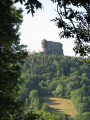
This walk, starting from Murol, will take you up to Le Tartaret, then on to the castle built inthe 12th century. Many painters came to Murol during the20th century and went on to found the Impressionist School.

Details

n°108854273
Creation:
Last update:
Last review:
–
  • Walking
    Activity: Walking
  • ↔
    Distance: 2.91 mi
  • ◔
    Average duration: 1h 55 
  • ▲
    Difficulty: Easy

  • ⚐
    Back to start: Yes
  • ↗
    Ascent: + 673 ft
  • ↘
    Descent: - 663 ft

  • ▲
    Highest point: 3,133 ft
  • ▼
    Lowest point: 2,723 ft

Description of the walk

Start from the car park on Rue de Landrode.

(S/E) Leave the car park, turn right and carry on straight ahead until you reach Rue d’Estaing.

(1) First turn right then left. At the end, first turn left then right, and take the first left.

(2) Cross Rue du Tartaret and carry on straight ahead.

(3) At the junction, turn right, then at the T-junction keep left, then take the first left, turn right at the end and carry on straight ahead.

(4) Turn left at the junction and head back to the crossroads from the outward journey.

(3) Turn right and follow the same route as on the way there until you reach the foot of Murol Castle. Before the car park, turn right to head up to the castle.

(5) At the bend, ignore the paths on the left and head towards the château. Then return to the bend.

(5) Turn right twice, then take the first left, down to the right, and head back to the starting point (S/E).

Waypoints

  1. S/E : mi 0 - alt. 2,884 ft - Car park at the - Château de Murol
  2. 1 : mi 0.31 - alt. 2,726 ft - Rue d’Estaing - Couze Chambon (rivière) - Affluent de l'Allier
  3. 2 : mi 0.51 - alt. 2,782 ft - Rue du Tartaret
  4. 3 : mi 0.65 - alt. 2,910 ft - Crossroads - Le Tartaret
  5. 4 : mi 1.46 - alt. 3,025 ft - Crossroads
  6. 5 : mi 2.32 - alt. 2,982 ft - Bend - Château de Murol
  7. S/E : mi 2.92 - alt. 2,884 ft - Car park at the - Château de Murol

Notes

No water source

Worth a visit

Le Tartaret

The castle

Other walks in the area

For more walks, use our search engine .

The GPS track and description are the property of this route's author. Please do not copy them without permission.