The Véris trail in Bauduen

Very nice course with beautiful views of Lake Sainte-Croix.

Details

236942
Creation:
Last update:
Last review:
  • Walking
    Activity: Walking
  • ↔
    Distance: 7.46 km
  • ◔
    Average duration: 2h 45 
  • ▲
    Difficulty: Easy

  • ⚐
    Back to start: Yes
  • ↗
    Ascent: + 209 m
  • ↘
    Descent: - 206 m

  • ▲
    Highest point: 686 m
  • ▼
    Lowest point: 483 m
  • ⚐ Country: France
  • ⚐ City: Bauduen (83630)
  • ⚑
    Start/End: N 43.732587° / E 6.176951°
  • ❏
    IGN map(s): Ref. 3442OT, 3442OTR
  • Hour-by-hour weather

Photos

Description of the walk

Park at the entrance of Bauduen, in a large car park.

(S/F) From the car park, go up Rue Grande, then right along Montée Saint Sauveur. Take the second road on the left, Chemin du Défends, and then the first right and follow it for about 3 km (just after marker 643).
This road starts out covered in asphalt and becomes stony (fine gravel). There is a gradual rise and the elevation is 160 m. This will be nearly the highest point of the course.
On a part of this first segment there is a beautiful view of the bottom of Bauduen cove.

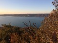
(1) At the intersection turn left on the path that and follow it easily staying on the main road to marker 652 where there is a beautiful view of Lake Sainte-Croix.

(2) The return follows a small trail that is intermittently marked with an arrow or Blue paint. Along this stretch there is a view of the north-west part of Lake Sainte-Croix, the village of Sainte-Croix-du-Verdon and the dam on the Verdon.

(3) At a junction, the path joins Sentier du Veris, cross it. A stone pile with a cairn on the left mark this crossing. Our trail ends on Chemin Sainte-Anne le Chelnei.

(4) Take the left, passing by two streets on the left and reach Rue du Cours that extends onto Grand Rue and returns to the car park (S/F).

Waypoints

  1. S/E : km 0 - alt. 483 m - Bauduen entrance car park
  2. 1 : km 2.16 - alt. 649 m - Path on the left
  3. 2 : km 4.34 - alt. 651 m - Viewpoints - Lac de Sainte-Croix
  4. 3 : km 6.53 - alt. 549 m - Crossing the Chemin de Véris
  5. 4 : km 6.86 - alt. 504 m - End of the trail - Verdon (rivière)
  6. S/E : km 7.46 - alt. 483 m - Bauduen entrance car park

Reviews and comments

4.4 / 5
Based on 61 reviews

Reliability of the description
4.3 / 5
Ease of following the route
4.4 / 5
Route interest
4.5 / 5
CHERVET
CHERVET

Overall rating : 4.7 / 5

Date of your route : Oct 12, 2025
Reliability of the description : ★★★★★ Very good
Ease of following the route : ★★★★★ Very good
Route interest : ★★★★☆ Good
Very busy route : No

This hike began on a beautiful day.
We set off from the car park 2 km before the original starting point in order to extend the route by 2 km, which allowed us to warm up before the climb, which starts right from the beginning and covers a distance of about 3 km. A very pleasant route, most of which is through woodland, unlike the climb.
No difficulties encountered.
Suitable for children aged 7-10.

Machine-translated

pvntmp
pvntmp

Overall rating : 5 / 5

Date of your route : Sep 30, 2025
Reliability of the description : ★★★★★ Very good
Ease of following the route : ★★★★★ Very good
Route interest : ★★★★★ Very good
Very busy route : No

A beautiful route offering stunning views of Lake Sainte Croix!
A varied hike with many shaded forest sections, accessible to most people.

Very reliable GPX track.
Thank you for the track!

Machine-translated

User 20047566

Overall rating : 4.7 / 5

Date of your route : Aug 30, 2025
Reliability of the description : ★★★★★ Very good
Ease of following the route : ★★★★★ Very good
Route interest : ★★★★☆ Good
Very busy route : No

Very pleasant loop with beautiful views of the lake, lovely forest section at the end. Reliable route. Lovely walk!

Machine-translated

Martiré Alain
Martiré Alain

Overall rating : 3.3 / 5

Date of your route : Jul 02, 2025
Reliability of the description : ★★★☆☆ Average
Ease of following the route : ★★★☆☆ Average
Route interest : ★★★★☆ Good
Very busy route : No

Starting from Bauduen and heading counterclockwise to the lake, it's perfect, but after the small beach, it gets complicated because the path isn't well defined and you end up climbing without knowing if you're on the right track. Thank goodness for GPS to get us back on the right track in the brush

Machine-translated

christine J.
christine J.

Overall rating : 4.3 / 5

Date of your route : Jul 21, 2025
Reliability of the description : ★★★★☆ Good
Ease of following the route : ★★★★★ Very good
Route interest : ★★★★☆ Good
Very busy route : No

A hike that is particularly interesting towards the end, passing through different landscapes: forest, boxwood and rocks.
The trail starts off wide but offers beautiful views of the lake.
Not very busy.
A lovely walk

Machine-translated

cotin
cotin

Overall rating : 5 / 5

Date of your route : Jun 05, 2025
Reliability of the description : ★★★★★ Very good
Ease of following the route : ★★★★★ Very good
Route interest : ★★★★★ Very good
Very busy route : No

A very pleasant, easy hike with beautiful views of the lake. Not very busy at this time of year.

Machine-translated

Mme Jeannin
Mme Jeannin
• Edited:

Overall rating : 5 / 5

Date of your route : Apr 23, 2025
Reliability of the description : ★★★★★ Very good
Ease of following the route : ★★★★★ Very good
Route interest : ★★★★★ Very good
Very busy route : No

At the time, we were lucky not to run into many people.
It was a really nice tour with some extraordinary views.

Machine-translated

Lolo B
Lolo B

Overall rating : 4.5 / 5

Date of your route : Apr 29, 2025
Reliability of the description : Not used / Not applicable
Ease of following the route : ★★★★★ Very good
Route interest : ★★★★☆ Good
Very busy route : No

A lovely, varied hike, with no difficulties and few visitors at this time of year.

Machine-translated

Bmrando
Bmrando

Overall rating : 5 / 5

Date of your route : Dec 18, 2024
Reliability of the description : ★★★★★ Very good
Ease of following the route : ★★★★★ Very good
Route interest : ★★★★★ Very good
Very busy route : No

A very nice walk, and the level indicated corresponds well to reality.
Precise and reliable information
A great success!

Machine-translated

eric76
eric76

Overall rating : 5 / 5

Date of your route : Dec 30, 2024
Reliability of the description : Not used / Not applicable
Ease of following the route : ★★★★★ Very good
Route interest : ★★★★★ Very good
Very busy route : No

Hello
I'm surprised by some of the comments, because it's perfectly labelled
I didn't even need the description.
I really liked the change of scenery in several places, undergrowth, view of the lake, passage through a rocky corridor and the village of Bauduen to visit too.

Machine-translated

Marcheur solitaire
Marcheur solitaire

Overall rating : 4 / 5

Date of your route : Sep 17, 2024
Reliability of the description : ★★★★☆ Good
Ease of following the route : ★★★★☆ Good
Route interest : ★★★★☆ Good
Very busy route : No

This is a pleasant and not too difficult circuit, the first part with very good paths, the second part with paths a little rougher, but without difficulties. beautiful viewpoints above the lake of sainte croix
on several parts of the route.

Machine-translated

Ixus
Ixus

Overall rating : 4.7 / 5

Date of your route : Sep 10, 2024
Reliability of the description : ★★★★☆ Good
Ease of following the route : ★★★★★ Very good
Route interest : ★★★★★ Very good
Very busy route : No

A very nice walk, and above all the magnificent village of Bauduen!

Machine-translated

Kamani
Kamani

Overall rating : 2.3 / 5

Date of your route : Aug 22, 2024
Reliability of the description : ★★☆☆☆ Disappointing
Ease of following the route : ★☆☆☆☆ Very disappointing
Route interest : ★★★★☆ Good
Very busy route : No

Hi, for a hike that was supposed to last 02H45 we took 04H20 to do it because the blue colour code markings left a lot to be desired. We had to turn back because at one point there were simply no more blue markings. As a result, we got lost and, of course, nobody was hiking that morning. Luckily we'd brought water and cereal bars. The signposting needs to be totally revised, not just the blue colour code, but also the yellow, green and red colour code. The view was beautiful though. A bon entendeur. Bye for now,

Machine-translated

Jacklynn48
Jacklynn48

Overall rating : 5 / 5

Date of your route : Jan 08, 2024
Reliability of the description : ★★★★★ Very good
Ease of following the route : ★★★★★ Very good
Route interest : ★★★★★ Very good
Very busy route : No

Very pleasant because you're on the ridge, so you have lovely views of the lake and the village of Sainte Croix.
Nice undergrowth among the fir trees on the 2nd part of the hike
No difficulties

Machine-translated

Fplum
Fplum

Overall rating : 4.7 / 5

Date of your route : Nov 13, 2023
Reliability of the description : ★★★★★ Very good
Ease of following the route : ★★★★☆ Good
Route interest : ★★★★★ Very good
Very busy route : No

As for the number of people using the trail, I answered no, but my answer is certainly not objective, as we did this hike on 10 November.

Machine-translated

Other walks in the area

For more walks, use our search engine .

The GPS track and description are the property of this route's author. Please do not copy them without permission.