Country:


(S/E) From the car park at the Rivière Noire information point. Take the main track which leads into the forest.
(1) At the first junction, keep to the right and cross a ford a little further on.
(2) Immediately after the ford, turn right (5m) to leave the track. The path is not at all obvious at first. Head into the forest, stepping over the large stones that form a sort of low wall. The path is very lightly marked (dark red) and climbs through the forest. After a few metres, it becomes visible through the trees. This path climbs steeply through ravines.
(3) A rocky section with a fixed rope in place to aid progress. Continue along this path, which keeps climbing. The vegetation changes.
(4) You’ll reach the top of a cliff offering a beautiful view. Go back a few metres and continue climbing along the ridge line. Pass by some small peaks before reaching the summit of Piton de la Petite Rivière Noire. Some sections are very muddy.
(5) Take a moment to enjoy the bench and the view at the summit. Then head down the path opposite to the one you took on the way up. Use the rope to help with the descent. At the bottom of the steep descent, keep to the left: this is the ridge path.
(6) Turn right to reach a small viewpoint, then return to the main path.
(7) You’ll reach a boundary marker marking the border between two districts of Mauritius. Continue along the path until you reach the road.
(8) Take the road on the left until you reach a large car park.
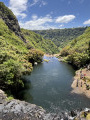
(9) At the car park, leave the road and follow a small path leading to a lovely viewpoint. Enjoy the view over the Rivière Noire Gorges, then head to the right.
(10) Pass a small pond; the path enters the woodland. Follow it.
(11) When you reach a wider path, follow it to the right until you come to a road; follow this to the left towards two masts.
(12) Leave the road at the bend and follow the path that runs between the two masts. The path begins to descend, more or less steeply. There are no junctions apart from a few small viewpoints.
(13) Reach a wide track; take it to the right and cross a ford a few dozen metres further on. Follow the Parakeet Trail, which descends alongside the river. At one point, veer away from it before coming back down to the river’s level.
(14) Walk past a shelter and turn sharply left, rejoining the original path and following it in the opposite direction back to the car park (S/E).

 Visorando Member
 Moderate


 Association / Club / Walk leader