Country:

 City:
City:


Follow the Red Rectangle throughout the route, unless otherwise stated.
Start at the Markstein visitor centre
(S) Head right towards the Grand Ballon. After the Markstein farmhouse inn, to the east of the resort, head towards the Hundskopf at the large information board for the snowshoe routes. Follow the path to the left of the road, which runs along the side of the ridge above the Route des Crêtes. Continue along the ridge until you pass the Hundskopf. You’ll reach a Fork in the road just after that.
(1) Follow the GR®5, which crosses the Route des Crêtes. Do not follow the path that climbs straight up the scree slope opposite, but take the Kapitaenstessla path on the right. Keep to the left on this path, which takes you round the Storkenkopf to the south. After the mountain refuge, continue straight on until you reach a road. Turn left towards the Col du Haag.
(2) At the Col du Haag (alt. 1,233 m, farmhouse inn), follow the path on the right which climbs up the south-western slope to the summit of the Grand Ballon. Then turn right, leaving the path on your right which leads to the Redslob Monument, to reach the summit.
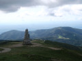
(3) At the Grand Ballon (alt. 1,424 m), take in the view at the foot of the Diables Bleus monument, dedicated to the Alpine hunters who defended the Vosges for France throughout the First World War. Leave the ‘Diables Bleus’ behind to reach the civil aviation radar, which sits atop the summit as a white sphere (orientation table), then head down the path opposite the resort towards the Col du Grand Ballon.
(4) At the pass, cross the Route des Crêtes opposite the chalet-hotel (closed) and take the path that descends diagonally to the right of the restaurant La Vue des Alpes (modified route), heading towards the Col du Judenhut. You’ll come to a Fork in the road.
(5) At the junction with the path marked with a Red Diamond, turn right towards the Grand Ballon farmhouse inn, making your way across the downhill ski runs.
(6) At the Grand-Ballon farm inn, continue the descent straight ahead, crossing the road twice. Then turn right towards Firstacker.
(7) At the Firstacker, carry on straight ahead, keeping above the road, towards the Col Amic, crossing a junction.
(8) At the pass, continue slightly uphill, crossing the road to reach the Château du Freundstein. Then descend to the Col du Freundstein.
(9) Take the path on the left and follow the long traverse to the right through damp gullies leading to the Vieil Armand (visit the Historial and the Hartmannswillerkopf National Necropolis), continuing straight on.
(10) Opposite the Historial car park, head up to the Molkenrain farmhouse inn, following the signs for Molkenrain. When you reach the thatched cottage, head straight across the road to the farm.
(11) Continue uphill behind the farm towards the Amis de la Nature chalet.
(12) At the Amis de la Nature hut in Molkenrain, head down through the forest towards Thann. The path passes a series of outcrops overlooking the Thur valley and former sites from the First World War. You’ll reach a pass at Camp Turenne.
(13) Carry on straight ahead and keep heading in the same direction until you reach Camp des Pyramides.
(14) Turn right and continue straight ahead at every junction until you reach the Col du Grumbach.
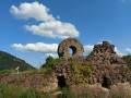
(15) Carry on straight ahead. At the junction, take the wide forest track on the right towards Thann. Then turn left, and take the path leading down to the right towards Engelbourg Castle.
(16) Also known as the ‘Witch’s Eye’, it overlooks the town of Thann, towards which you should continue. Turn left, then right, and keep following the road straight ahead until you reach the bridge over the River Thur.
(17) Turn left, then carry on straight ahead until you reach the collegiate church. First turn right then left, and you’ll reach Thann Town Hall (E).
 Tourist office
 Easy
Easy  Visorando Member
 Moderate
 Difficult