The Swabian Jura and Hohenzollern Castle

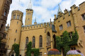
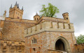
The ancestral seat of the Prussian royal family and the Princes of Hohenzollern, Hohenzollern Castle is one of the most visited castles in Europe. Perched on a high hill in Swabia, the building, adorned with numerous towers, has a picturesque, medieval appearance when viewed from a distance. The view from Hohenzollern Castle is well worth the detour, though you’ll need to be prepared for a brisk 20-minute walk to finally reach the castle.

Details

12455986
Creation:
Last update:
Last review:
  • Walking
    Activity: Walking
  • ↔
    Distance: 1.43 mi
  • ◔
    Average duration: 1h 10 
  • ▲
    Difficulty: Easy

  • ⚐
    Back to start: Yes
  • ↗
    Ascent: + 551 ft
  • ↘
    Descent: - 531 ft

  • ▲
    Highest point: 2,802 ft
  • ▼
    Lowest point: 2,402 ft

Photos

Description of the walk

Hohenzollern Castle is located 20 km from Tübingen and approximately 65 km south of Stuttgart. From the B27, take the Hechingen exit. GPS coordinates: N 48° 19' 32.52 E 8° 57' 49.968. Car park address: Hohenzollern Castle Car Park 72379 Bisingen, Germany.
Please note: if you wish to visit the castle, remember to buy your tickets at the gift shop, located in the car park.

(S/E) To start the climb up to the castle, go to the right of the souvenir shop, located at the south-eastern end of the car park, to join a small path heading south. At the junction, turn left, cross the road and continue along the path, heading east. You will reach the tarmac road at a bend.

(1) Leave the bend to the left and climb the stairs (around 150 steps) on the path called Main-Neckar-Rhein-Weg. Continue the climb until you reach the fence, which forces you to turn right, and you’ll reach a bend in the tarmac road.

(2) Continue climbing the road to the left. Watch out for the frequent shuttle bus. You will reach the access ramp to the castle.

(3) Even if you do not wish to visit the castle, you can walk up to it and access the inner courtyard and the rampart walk.
Once you have finished your visit, head back down the ramp to rejoin the tarmac road.

(3) Continue down the descent, either via the road (the option shown on the map and in the description) or via the footpath which you’ll find at thefirst bend.

(2) Take the path on the right to return to your starting car park (S/E).

Waypoints

  1. S/E : mi 0 - alt. 2,402 ft - Castle car park
  2. 1 : mi 0.16 - alt. 2,539 ft - Stairs
  3. 2 : mi 0.31 - alt. 2,644 ft - Bend in the tarmac road
  4. 3 : mi 0.91 - alt. 2,710 ft - Access ramp - Château de Hohenzollern
  5. S/E : mi 1.43 - alt. 2,402 ft - Car park

Notes

The walk up is quite steep and includes at least 150 steps. It is also possible to walk up via the road, but you must watch out for the shuttle buses (which charge a fee), which go up and down frequently.

Video of the castle: Here

Castle website: Here

Practical information: parking: €2. Admission: €12 to visit the interiors (guided tour), €7 for the exteriors only. Please note, tickets can be purchased at the kiosk in the car park at the bottom or online here. It would be a shame to make the long climb only to realise you don’t have your tickets.

Allow about twenty minutes for a steep climb, part of which is on steps and part of which is a slope without steps. Please note, the path is tarmac, but if it rains, the wooden steps can be slippery.

Worth a visit

Tour of the castle

Reviews and comments

For more walks, use our search engine .

The GPS track and description are the property of this route's author. Please do not copy them without permission.