The Grand Ballon

Hike undertaken in July on the Alsatian side.
Discover the flora and fauna on the pastures of the Vosges.

Details

22507
Creation:
Last update:
Last review:
  • Walking
    Activity: Walking
  • ↔
    Distance: 2.63 km
  • ◔
    Average duration: 1h 10 
  • ▲
    Difficulty: Moderate

  • ⚐
    Back to start: Yes
  • ↗
    Ascent: + 158 m
  • ↘
    Descent: - 150 m

  • ▲
    Highest point: 1,423 m
  • ▼
    Lowest point: 1,287 m

Photos

Description of the walk

Car park by the Route des Crêtes.

Take the path that winds its way up to the Grand Ballon. It is well signposted and you are advised to follow it to protect the flora.

(1) Once at the summit, a commemorative statue awaits hikers and an aeronautical station serves as an observatory.

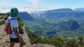
Continue along the ridge to admire the Vosges Mountains. Choose a sunny day.

The return journey follows the same path.

Waypoints

  1. S/E : km 0 - alt. 1,287 m
  2. 1 : km 1.01 - alt. 1,423 m - Grand Ballon
  3. S/E : km 2.62 - alt. 1,287 m

Notes

Early in the morning, you might be lucky enough to spot some chamois.

Bring a camera, drinks and a picnic to enjoy at the summit.

Worth a visit

Guebwiller.
The Route des Crêtes.

Reviews and comments

4.4 / 5
Based on 5 reviews

Reliability of the description
4.3 / 5
Ease of following the route
4.6 / 5
Route interest
4.4 / 5
Orando974
Orando974 ★

Overall rating : 5 / 5

Date of your route : May 20, 2023
Reliability of the description : Not used / Not applicable
Ease of following the route : ★★★★★ Very good
Route interest : ★★★★★ Very good
Very busy route : Yes

I did this walk a few days ago, but it was part of a much longer route starting from Soultz. It’s a short, family-friendly route with no particular difficulties and magical views all along the way. I highly recommend it.

Machine-translated

SIMON FREDI
SIMON FREDI

Overall rating : 5 / 5

Date of your route : Sep 23, 2021
Reliability of the description : ★★★★★ Very good
Ease of following the route : ★★★★★ Very good
Route interest : ★★★★★ Very good
Very busy route : Yes

A lovely walk as the season draws to a close. Unfortunately, the view of the Black Forest and the Alps was obscured by a light mist. There were still plenty of tourists on this route. Even though we’re locals and regularly hike in the Vosges, the path leading up from Le Haag was still unfamiliar to us. The spring that flows almost at the summit of the Grand Ballon raises questions among walkers. This water comes from the Alps and reaches Alsace via a communicating vessel.

Machine-translated

frenchydoc1
frenchydoc1

Overall rating : 4 / 5

Date of your route : Aug 09, 2021
Reliability of the description : ★★★★☆ Good
Ease of following the route : ★★★★☆ Good
Route interest : ★★★★☆ Good
Very busy route : Yes

A very busy spot with tourist buses passing through. I personally extended the route slightly by going via the Haag farm, which is very well signposted from the Club Vosgien chalet opposite the car park. This path is much more peaceful and pleasant.
Otherwise, the radar station is clearly worth a visit, offering a magnificent view of the Alsace plain, well illustrated by directional signs placed all around the footbridge encircling the radar dome.

Machine-translated

Isa26
Isa26

Overall rating : 4.7 / 5

Date of your route : Jul 19, 2021
Reliability of the description : ★★★★★ Very good
Ease of following the route : ★★★★★ Very good
Route interest : ★★★★☆ Good
Very busy route : Yes

As usual, the route and the Visorando guide, combined with the GPX navigation, are spot on 😊

Machine-translated

Etienne88
Etienne88

Overall rating : 3.7 / 5

Date of your route : Jun 29, 2013
Reliability of the description : ★★★☆☆ Average
Ease of following the route : ★★★★☆ Good
Route interest : ★★★★☆ Good

A lovely walk, but I’d suggest making it a bit longer.
Park your car at the Markstein car park and follow the path that runs alongside the road to the Col du Haag; then head towards the Grand Ballon, go round it and return to the Haag farm, climb the fairly steep slope behind the farm, cross the pastures, and head back down towards the road following the path; from the road, take the path back in the opposite direction to the Markstein.
A very beautiful hike;

Machine-translated

Other walks in the area

For more walks, use our search engine .

The GPS track and description are the property of this route's author. Please do not copy them without permission.