The Doulezon Green Route

A walk in Doulezon around a remarkable medieval church, through which two streams flow: the Lestage and the Pédayne.

Details

n°34375290
Creation:
Last update:
–
Last review:
  • Walking
    Activity: Walking
  • ↔
    Distance: 2.15 mi
  • ◔
    Average duration: 1h 10 
  • ▲
    Difficulty: Easy

  • ⚐
    Back to start: Yes
  • ↗
    Ascent: + 187 ft
  • ↘
    Descent: - 197 ft

  • ▲
    Highest point: 318 ft
  • ▼
    Lowest point: 108 ft
  • ⚐ Country: France
  • ⚐ City: Doulezon (33350)
  • ⚑
    Start/End: N 44.792413° / W 0.004709°
  • ❏
    IGN map(s): Ref. 1637SB
  • Hour-by-hour weather

Description of the walk

Start at Doulezon, by the car park next to the church and cemetery.

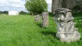
(S/E) From the car park, head towards the central crossroads in Doulezon (the three routes are signposted with green, red and yellow arrows, marked by our characteristic Doulezon ‘laughing pots’), turn left onto Rue ‘Le Bourg Sud’ then immediately right, heading south towards Micouleau and Touron. Very quickly ignore a path coming from the right. Take the path down towards Touron, passing a family tomb and then an old washhouse. Continue along the shaded path beside the Touron spring, where it feels almost tropical, until you reach a crossroads.

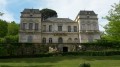
(1) Carry on straight ahead, leaving the Chemin Jaune on your left. Continue along the path opposite, then take the path through the trees to reach the valley, where you’ll catch sight of the imposing Dartigues house on your right. Carry on to the next crossroads.

(2) Take the path that climbs up the hill to the right (there may be donkeys and a goat at the hut). Continue along the path facing the climb to reach the first junction.

(3) Turn right, leaving the Red Path straight ahead, and walk past the beautiful gate of the Dartigues house.

(4) Turn left towards the Moulin de Marchemal and walk for 600 metres, then head right through the vineyards and return towards Doulezon, keeping to the right at all times (S/E).

Waypoints

  1. S/E : mi 0 - alt. 295 ft - Car park near the cemetery - Église Notre-Dame (Doulezon)
  2. 1 : mi 0.44 - alt. 125 ft - Crossroads
  3. 2 : mi 1 - alt. 115 ft - Junction
  4. 3 : mi 1.17 - alt. 226 ft - Intersection
  5. 4 : mi 1.38 - alt. 249 ft - Dartigues House website
  6. S/E : mi 2.15 - alt. 295 ft - Car park near the cemetery - Église Notre-Dame (Doulezon)

Notes

This route was created by walkers from the village of Doulezon.
A leaflet detailing the history of this village is available at the town hall.

Castillon-la-Bataille Tourist Information Centre
5 Allées de la République
33350 Castillon-la-Bataille
Tel: +33 (0)5 57 40 27 58
contact@tourisme-castillonpujols.fr
https://www.tourisme-castillonpujols.fr/

Worth a visit

(S/E) Notre-Dame Church

Before the signpost (1), an old Protestant tomb and, at Le Touron on the right, a very old wash house.
(1) On the right, a field where donkeys graze and a spring said to have petrifying properties!
As you continue, you’ll see hollowed-out cliffs on the right and a sheep pasture where there is said to be a vaulted well.

(4) Maison Dartigues
Doulezon is home to a large Gallo-Roman villa covering nearly three hectares.

Reviews and comments

5 / 5
Based on 1 review

Reliability of the description
5 / 5
Ease of following the route
5 / 5
Route interest
5 / 5
marybleu
marybleu

Overall rating : 5 / 5

Date of your route : Mar 09, 2026
Reliability of the description : ★★★★★ Very good
Ease of following the route : ★★★★★ Very good
Route interest : ★★★★★ Very good
Very busy route : No

An easy, leisurely route to get back into shape after weeks of rain.
I didn’t spot the mill after Château Dartigues and its impressive gate.
Thanks to the Doulezon walkers for these three routes

Machine-translated

Other walks in the area

For more walks, use our search engine .

The GPS track and description are the property of this route's author. Please do not copy them without permission.