Lac des Perches (Vosges)

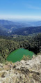
A lovely little walk starting from the Rouge Gazon car park and ending at the magnificent Lac des Perches. A glacial lake covering 4.5 hectares and 17 metres deep.

Details

10709
Creation:
Last update:
Last review:
  • Walking
    Activity: Walking
  • ↔
    Distance: 2.25 mi
  • ◔
    Average duration: 1h 45 
  • ▲
    Difficulty: Moderate

  • ⚐
    Back to start: Yes
  • ↗
    Ascent: + 817 ft
  • ↘
    Descent: - 833 ft

  • ▲
    Highest point: 4,003 ft
  • ▼
    Lowest point: 3,228 ft

Photos

Description of the walk

(S/E) Park in the car park next to the Rouge Gazon farmhouse inn and hotel. Take the path that climbs up behind the hotel through the pasture.

(1) At the edge of the forest, turn left (the signposting has disappeared) and follow the edge of the woodland. Before the chairlift, access the Tête des Perches through an opening in the park’s fence (wooden planks)

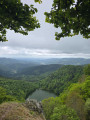
(2). You’ll have a lovely view of the lake. Retrace your steps and turn right towards the cable car.

(3) There, a path that is not very visible and unmarked crosses the woods to the right, then descends steeply to the Col des Perches. I do not recommend taking this path in wet weather as it will be very slippery. At the pass, head down to the right towards the lake.

(4) For the return journey, head back up to the pass and take the path on the left,the GR®531, signposted ‘red grass 0h30’ (there are other, more difficult routes). Simply follow the single path and you’re there. It’s not very difficult and it’s magnificent (S/E)

Waypoints

  1. S/E : mi 0 - alt. 3,589 ft - Rouge Gazon
  2. 1 : mi 0.48 - alt. 3,904 ft - Edge of the forest
  3. 2 : mi 0.66 - alt. 3,973 ft - Tête des Perches
  4. 3 : mi 0.72 - alt. 3,993 ft - Cable car. Direction - Col des Perches
  5. 4 : mi 1.35 - alt. 3,232 ft - Lac des Perches
  6. S/E : mi 2.25 - alt. 3,589 ft - Rouge Gazon

Notes

There are no drinking water points along the route. Make sure you wear sturdy footwear as the descent is steep and slippery after the cable car (I’ve rated this hike as ‘moderate’ because of this).
My GPS shows a total ascent of 454m and a distance of 4.89km in 3D, with a walking time of 1h30, not including stops.

Worth a visit

For those who love lakes, you can carry on a little further to the Neuweiher lakes. This will take a further 2 hours.

Always be cautious and plan ahead when you're outdoors. Visorando and the author of this route cannot be held responsible for any accidents occurring on this route.

The GR® and PR® markings are the intellectual property of the Fédération Française de Randonnée Pédestre.

Reviews and comments

4.4 / 5
Based on 3 reviews

Reliability of the description
4.3 / 5
Ease of following the route
4 / 5
Route interest
5 / 5
User 15603651

Overall rating : 4 / 5

Date of your route : Aug 08, 2026
Reliability of the description : ★★★☆☆ Average
Ease of following the route : ★★★★☆ Good
Route interest : ★★★★★ Very good
Very busy route : Yes

I only did the ‘Rouge Gazon’ route to the lake via the Col des Perches, without going via the Tête des Perches. Blue Rectangle signposts. A few technical sections, and the slope is steep from the pass to the lake. Hiking boots are absolutely essential. A lovely walk with stunning scenery.
Lots of people swimming despite the ban.

Machine-translated

User 3768433

Overall rating : 4.3 / 5

Date of your route : Aug 11, 2025
Reliability of the description : ★★★★★ Very good
Ease of following the route : ★★★☆☆ Average
Route interest : ★★★★★ Very good
Very busy route : Yes

The unmarked section of the trail is very dangerous for inexperienced or unequipped hikers (rocks and gravel on a steep slope), especially when descending. There is no point in taking this route unless that is precisely what you are looking for.
You might as well do the longer loop, which is marked and passable without being suicidal, especially as the views of the lake are superb.
On summer Sundays, Lac des Perches is a bit like a motorway, so go there at the end of the afternoon. And please, if it says "no swimming", it means no swimming. I can't believe how disrespectful people are.

Machine-translated

gibrando
gibrando

Overall rating : 5 / 5

Date of your route : May 19, 2023
Reliability of the description : ★★★★★ Very good
Ease of following the route : ★★★★★ Very good
Route interest : ★★★★★ Very good
Very busy route : Yes

A few slightly steep sections, but a very lovely walk

Machine-translated

Other walks in the area

For more walks, use our search engine .

The GPS track and description are the property of this route's author. Please do not copy them without permission.