La Peira Escrita and the Étang du Diable

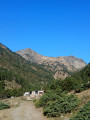
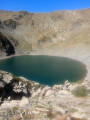
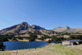
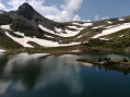
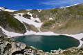
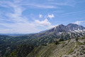
This walk takes you to the Peira Escrita valley, a historic landmark in Capcir, and on to the unexpected Étang du Diable, with its devilishly perfect circle! To do this, we’ll follow a section of the GR® de Pays Tour du Capcir (marked in red and yellow), then take an off-trail route marked with cairns.

Details

n°107743547
Creation:
Last update:
Last review:
–
  • Walking
    Activity: Walking
  • ↔
    Distance: 10.46 mi
  • ◔
    Average duration: 9h 05 
  • ▲
    Difficulty: Difficult

  • ⚐
    Back to start: Yes
  • ↗
    Ascent: + 4,865 ft
  • ↘
    Descent: - 5,033 ft

  • ▲
    Highest point: 7,720 ft
  • ▼
    Lowest point: 5,318 ft

Photos

Description of the walk

Park in the car park at Pont dels Plans de l’Orriet. Please note the information in => Practical Information

(S/E) From the car park, take the correct forest track heading west towards the Barraque de la Jaceta: follow the red and yellow GR® de Pays Tour du Capcir markings.

(1) Carry on until you reach the huts at Jaça de la Llosa.

(2) Follow the path to La Jaça de les Barreres.

(3) Cross the footbridge and continue along the path, following the red and yellow markings. The path runs alongside the Rec de la Peira Escrita at varying distances and leads to a flat area crossed by several streams.

(4) Leave the red and yellow marked path and take an ascending track heading south-west (cairns). Gain altitude towards the Peira Escrita valley and reach the information board about the engraved stones site.

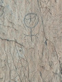
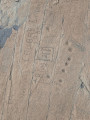
(5) Pass successively through the waypoints (6), (7) and (8), which mark the main engraved stones. There are others, and you’ll need to look for them amongst the scree. Then rejoin the cairn-marked path which climbs south-west, then north-west, to reach the perfectly circular Étang du Diable.

(9) Turn back, leaving the detour you took on the way up to see the engraved stones on your right, and rejoin the GR® de Pays Tour du Capcir.

(4) Turn left back onto the path you took on the way up, heading in the opposite direction, to return to the car park (S/E).

Waypoints

  1. S/E : mi 0 - alt. 5,486 ft - Pont dels Plans de l’Orriet car park
  2. 1 : mi 0.5 - alt. 5,381 ft - Barraque de la Jaceta
  3. 2 : mi 1.34 - alt. 5,761 ft - Huts at La Jaça de la Llosa
  4. 3 : mi 1.93 - alt. 5,909 ft - Footbridge
  5. 4 : mi 4.61 - alt. 6,890 ft - Common junction (out and back)
  6. 5 : mi 5.18 - alt. 7,569 ft - Information board about the engraved stones
  7. 6 : mi 5.26 - alt. 7,569 ft - Engraved rock 1
  8. 7 : mi 5.27 - alt. 7,388 ft - Engraved rock 2
  9. 8 : mi 5.29 - alt. 7,562 ft - Engraved rocks 3 and 4 - Étang du Diable
  10. 9 : mi 5.67 - alt. 7,694 ft - Devil’s Pond
  11. S/E : mi 10.46 - alt. 5,318 ft - Pont dels Plans de l’Orriet car park

Notes

To reach the Pont dels Plans de l’Orriet car park, the start of the walk, you must walk through the village of Espousouille and pass the cemetery (on your left). Continue along the forest track to the right for 4.5 km: passability uncertain. In September 2026, the track was in poor condition. The track is impassable for low-clearance vehicles and is not recommended after heavy rain: there are numerous puddles on the track...

A high-mountain route, wild and little-used, requiring good physical fitness and suitable kit: walking poles, mountain boots, appropriate clothing and food, maps and a compass, and the Visorando app.

In the mountains, grassy slopes are just as dangerous as snow-covered ones, so stay alert!

In summer, herds are present in the Peira Escrita valley.

Only set out on the route in very good weather with clear visibility: no wind, no rain, and no cold!

It can suddenly get very cold at high altitude, and thunderstorms can build up very quickly!

Worth a visit

(6), (7) and (8) The engraved stones in the Piera Escrita valley: you’ll need to look for them amongst the schist boulders in the valley. Most are covered in inscriptions dating from the 16th to the 20th centuries, but you’ll need to examine them carefully to discover the Neolithic glyphs.

(9) The Devil’s Pond (Estany del Diable).

Always be cautious and plan ahead when you're outdoors. Visorando and the author of this route cannot be held responsible for any accidents occurring on this route.

The GR® and PR® markings are the intellectual property of the Fédération Française de Randonnée Pédestre.

Other walks in the area

For more walks, use our search engine .

The GPS track and description are the property of this route's author. Please do not copy them without permission.