Park in the Route de Paris car park.
(S/E) With your back to the car park, take the Chemin de la Cure opposite, marked by a concrete cross, in the no-entry direction. At the end of the street, turn left onto the Chemin de Lachat, then very quickly right onto the Chemin des Greffettes. Cross the fields; the path continues to the left and runs alongside the forest until it reaches the Chemin de Cherin.
(1) Continue left along this path, passing a fountain and a spring. Pass the hamlet of Cherin on your left and arrive at a fork.
(2) Take a path hidden by foliage. Initially, it climbs steeply and then more gently as it winds through the boxwood. Emerging onto flat ground, cross a botanical garden featuring various tree species, then follow a stony track to reach point 439 (at a place called Les Branles).
(3) Head left towards the north along the track to reach point 522.
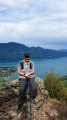
(4) Take the path climbing to the right towards the Grotte des Fées.
You will reach a crossroads.
(5) Make a round trip to the cave (a ‘Viewpoint’ sign indicates the direction).
Return to the crossroads and continue climbing along the track that branches off to the left (north).
Follow this track through the forest for about 1 km – marked with yellow signs – until you reach a junction.
(6) Pass the path on your right that climbs to the Croix de Meyrieu and head down to the left towards the hamlet of Les Granges de Brison. On the way, you’ll pass a clearing with a viewpoint and, further down, a path branches off to the left.
(7) Continue into the hamlet of Les Granges de Brison and, at a hairpin bend, leave the road and head south.
(8) Head south along a pleasant path, grassy at first and then stony, as it winds its way up a series of hairpin bends.
Stay on the path through the vineyards until you reach (2), then retrace your steps along the path to return to the car park (S/E).