Country:
 City:
City:


Starting point: the hamlet of Chez les Gay
Car park: on the right after the first house past the junction towards Marlioz
(S/E) From the car park, take the Chemin du Muralet, which climbs straight up above the transformer. Continue to the Route du Chef-Lieu D7.
(1) Cross the road and turn right onto the Route de l’Ancienne Poste, which runs alongside the lower wall of the Clos du Château (the road becomes a track). At the end of the road, take the rural track known as the Chemin des Emberjoux, on the left (this takes you round to the back of the church).
(2) Walk round the church (view of the church and the castle). Take the Route de l’Église D123 on the right and head up to the gravel car park at the Croix Richard.
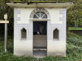
(3) Take the flat path on the left which leads into the forest. Continue to the Marlioz Chapel.
(4) Continue to the right along the path through the forest.
(5) On leaving the forest, take the road on the right as far as the junction at the hamlet of Sur le Sion.
(6) Carry on straight ahead along the country lane known as ‘du Sion’ (often a muddy track) until you reach the car park at the hamlet of Pierre 33.
(7) Take the VC1 road on the left to the village of Minzier. Note the wash house on the right, opposite the cemetery and Minzier Chapel, and, just behind it, an architectural curiosity nicknamed ‘the bubble house’.
(8) Turn back. At the wash house, take the road on the right towards Marlioz / Chavannaz. Continue along the road towards the hamlet of Sur le Sion (passing the Coquetières picnic area).
(9) Carry on to the left until you reach the hamlet of Sur le Sion.
(6) Turn right, heading in the opposite direction to the outward journey, onto the Route de la Forêt and return to a junction you passed on the way out.
(5) Carry on straight ahead along the road until you reach the Stop sign. Turn right towards Pont Fornand / Savigny on the D123 for 50 m.
(10) Take the Chemin des Époussières, which winds down to the left between the houses. At the bottom of the path, take the path on the left to rejoin the Route du Chef-Lieu. Continue along this road until you reach the Chemin du Muralet (top).
(1) Follow it downhill to the right until you reach the car park (S/E).
 Tourist office
 Easy
Easy 
 Visorando Member