


 Country:

 City:
City:


You can park your car in the small car park at the end of Rue de la Zundelhutte.
(S/E) At the entrance to the forest, take the path on your right and head downhill, cross the Andlau and continue to the junction with the GR®5 marked with a Red Rectangle.
(1) Leave the return path on your right, head uphill to the left following the GR®5, cross the forest track, and further on join a GR® path coming from the right; follow it to the left for about 150 m until you rejoin the forest track.
(2) Turn right onto it and continue uphill. At the next two junctions, take the path on the left and continue uphill. After the second junction, cross the crossroads and head uphill along the path on the left until you reach the next junction.
(3) Follow the path to the right and head up towards the Vieille Métairie mountain hut. It has a shaded picnic area.
(4) After a break, take the path that descends to the right immediately after the refuge, heading north-east. It joins the Chemin Forestier du Kohlschlag; follow it to the left for 40 metres.
(5) Continue down the path on the right. After about 500 m, cross a second and then a third forest track; shortly afterwards, you’ll reach the Rohrbach stream.
(6) Cross the stream and follow the path, which gradually turns southwards before curving sharply to the left and joining a forest track (IGN elevation 752).
(7) Cross this and the next one shortly afterwards, and continue for about 300 m until you reach a junction.
(8) Turn sharply right and continue along this path, which descends gently towards the Chalet de Rohrbach, with Rohrbach behind you. This is the perfect spot for another short break.
(9) Take the (unmarked) path on the left which follows the stream along its right bank, heading due south. It soon joins the GR®5.
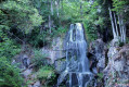
(10) Follow it to the right as it climbs. After about 800 m, cross the Kaltenbaechel and continue to the Andlau Waterfall.
(11) Walk past the waterfall and continue uphill along the GR®5 to the junction you passed on the way there.
(1) Carry on in the opposite direction along the route you took on the way there to return to the waterfall car park (S/E).

 Visorando Member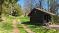
 Difficult
 Moderate
 Tourist office
