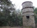
The drystone shelter of the Pain de Sucre

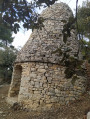
A short hike that presents a few challenges but will allow you to enjoy a magnificent panorama and discover the very distinctive drystone shelter of Pain de Sucre.

Details

n°132631
Creation:
Last update:
Last review:
  • Walking
    Activity: Walking
  • ↔
    Distance: 2.03 mi
  • ◔
    Average duration: 1h 20 
  • ▲
    Difficulty: Moderate

  • ⚐
    Back to start: Yes
  • ↗
    Ascent: + 433 ft
  • ↘
    Descent: - 427 ft

  • ▲
    Highest point: 1,811 ft
  • ▼
    Lowest point: 1,407 ft

Photos

Description of the walk

To start the walk, park in the crematorium car park.

(S/E) The walk begins gently with the climb up to Saint-Martin-les-Eaux. You can’t miss it – it starts at the far end of the car park, where a barrier prevents vehicle access.

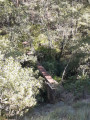
(1) After about 350 m, you’ll see a path branching off to the right and leading down towards a dry stream bed. It’s marked by a wooden post with a green marker. Take this path and cross the stream via a small wooden bridge made from pallets, which has been built to allow crossing in case there’s water after rain. Carry on until you reach a three-way junction about 250 m further on.

(2) Please note: just before the three-way junction, there is what looks like a path branching off to the left. This is, in fact, a gully carved out by heavy rainfall: do not take this ‘pseudo-path’. The three-way junction consists of one path leading down to the right and another leading up to the left: take the left-hand path. This is where the difficult part begins. Follow the path until you reach a slightly wider track.

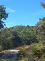
(3) Turn left. The path becomes steep. At the second hairpin bend, ignore the shortcut on the right – which you’ll take on the way back – and carry on straight ahead. Further on, take a hairpin bend to the right.

(4) Look out for the start of the shortcut mentioned above on your right and carry on straight ahead to reach the drystone shelter of the Pain de Sucre.

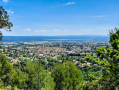
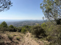
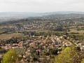
(5) Take the opportunity to visit this beautiful spot and admire the marvellous panoramic view over Manosque and the Durance valley. Then begin the descent along the path you came up on.

(4) Just before the first sharp bend to the right, turn left onto the small path which descends steeply to join the path you took on the way up. Take this path to the left and follow the outward route exactly in the opposite direction to return to the car park (S/E).

Waypoints

  1. S/E : mi 0 - alt. 1,421 ft - Car park
  2. 1 : mi 0.27 - alt. 1,460 ft - Start of the trail
  3. 2 : mi 0.43 - alt. 1,417 ft - Three-way junction
  4. 3 : mi 0.54 - alt. 1,575 ft - Junction with a wider path
  5. 4 : mi 0.87 - alt. 1,706 ft - Shortened route
  6. 5 : mi 1.12 - alt. 1,811 ft - Drystone shelter of Pain de Sucre
  7. S/E : mi 2.03 - alt. 1,421 ft - Car park

Notes

Good walking boots are essential (the ground may be slippery in many places).
Don’t forget to take water with you, especially in dry, hot weather. There are no facilities for buying refreshments. There are picnic tables on a terraced area, to the top left of the drystone shelter.

Worth a visit

Look out for the local flora and fauna (the vegetation is particularly lush in places).
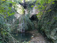
On your way, visit an old cistern.
Then, of course, visit the drystone shelter and the surrounding facilities.
Enjoy the magnificent view over Manosque and the Durance Valley.

Reviews and comments

3.7 / 5
Based on 2 reviews

Reliability of the description
3.5 / 5
Ease of following the route
3 / 5
Route interest
4.5 / 5
Valladolid
Valladolid

Overall rating : 4 / 5

Date of your route : Apr 07, 2024
Reliability of the description : ★★★★☆ Good
Ease of following the route : ★★★★☆ Good
Route interest : ★★★★☆ Good
Very busy route : Yes

A nice little walk. However, I couldn’t quite work out how to get to the drystone shelter itself.

Machine-translated

MONTES
MONTES

Hello,

There were four of us.
All four of us took the path leading up to the masts. Yet we were a kilometre away from the drystone shelter...
In our opinion, there’s a small detail missing which means you end up climbing up to the antennas… instead of heading towards the drystone shelter.
I’m going to suggest to the local council that they put in a bin… this spot is far too beautiful to be marred by picnic rubbish (which just goes to show that people do visit the site…)
Thank you once again for introducing us to this place.

Machine-translated

jodeman
jodeman
• Edited:

Hello,
I mapped the route twice before uploading it to Visorando.
Could you please let me know what you found to be reasonably reliable in the description and what you found disappointing about the map route, so that I can improve it?
Personally, I thought it was described quite well.
As for the condition of the site, when I visited, there was a bit of graffiti but the place was clean.
Unfortunately, some people have no respect for anything...
Thank you.

Machine-translated

bibi
bibi ★

Thank you for your feedback, but where exactly on the map did the route not match up with reality? And the same goes for the average description – did you get lost?
Visorando and the author are not responsible for the upkeep of the footpaths or the picnic tables; however, if you mention it in the comments, those in charge of maintenance might see it – otherwise, you’ll need to report it to the local council.

Machine-translated

MONTES
MONTES

Overall rating : 3.3 / 5

Date of your route : Sep 06, 2015
Reliability of the description : ★★★☆☆ Average
Ease of following the route : ★★☆☆☆ Disappointing
Route interest : ★★★★★ Very good

The uphill section is very steep and isn’t suitable for young children or some elderly people. It’s a shame, as this drystone shelter and its surroundings are well worth a visit.
Above all, do not take the path leading up to the radio masts – which is what we did – as the Fork in the road could have done with some wooden signposts.
The picnic tables are already covered in graffiti, and plastic bottles litter the ground… how disheartened the team who restored the site (the terraces and the drystone shelters) must feel.
Well worth a visit.

Machine-translated

Other walks in the area

For more walks, use our search engine .

The GPS track and description are the property of this route's author. Please do not copy them without permission.