The old Haute-Saône Canal from Frahier to Ronchamp

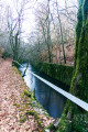
A pleasant walk through the Chérimont Forest. You’ll discover the old Haute-Saône Canal, which was intended to link Frahier to Ronchamp. In winter, the trees have shed their leaves, offering a clearer view of the landscape. As the route runs mainly through woodland, the temperature remains cool and pleasant in summer. A short round trip takes you to the Chérimont Underground Passage.
The walk is signposted.

Details

6212090
Creation:
Last update:
Last review:
  • Walking
    Activity: Walking
  • ↔
    Distance: 5.40 mi
  • ◔
    Average duration: 3h 00 
  • ▲
    Difficulty: Moderate

  • ⚐
    Back to start: Yes
  • ↗
    Ascent: + 574 ft
  • ↘
    Descent: - 577 ft

  • ▲
    Highest point: 1,499 ft
  • ▼
    Lowest point: 1,227 ft

Description of the walk

The start of the walk is on the D127 near the hamlet of Le Grand Crochet. The D127 links Ban de Champagney to Etobon. There is a car park with space for a few cars.

The start is 650 m from the D619 (formerly the N19) as seen from Le Grand Crochet. An information sign is located at the start of the walk on the west-hand side of the D127 (on the right at the first hairpin bend coming from Champagney). The walk is marked in yellow, with either a Yellow Ring or a Yellow Triangle depending on the section.

Yellow Ring markings

(S/E) Head westwards into the forest. The path climbs slightly, then descends and crosses a small stream. N.B. The purple line intended to show the path on the 1:25,000 map is incorrect here.

(1) At the junction just after the stream, turn left. Cross asecond stream and pass three paths on your right. Walk alongside a pond at a distance on your left. Cross the canal flowing out of the pond. At this point, it is called the Beuveroux.

(2) Turn left at the junction just after the stream. Walk alongside the pond on the opposite bank and then alongside the canal, leaving one path on your right.

(3) Continue along the canal, ignoring the two paths on the right. The path climbs to pass over the canal, which runs underground at this point.

(4) Cross the D127 and continue along the forest track opposite, just after the barrier (Yellow Ring signpost). Pass two tracks on the right. The forest track climbs, passes the 428-metre altitude and descends again. It overlooks the canal on the left. Descend to a forest hut near the canal.

Yellow Triangle signposting

(5) Then turn left (do not cross the canal). Follow the canal on your right (a lovely walk). Continue to the entrance to the Chérimont Tunnel, a superb structure well worth a detour.

(6) Retrace your steps.

Yellow Ring Markings

(5) Once back at the forest hut, turn left and cross the bridge over the canal. Immediately after the bridge, turn left and turn left again 20 metres further on. The path climbs through the forest, initially west-north-west then north-west.

(7) At the crossroads, carry on straight ahead (do not follow the path marked with a Yellow Triangle to the left). The path passes the summit of Mont de Mavou (elevation 437) and descends. Pass two side paths on the right. When you reach the D127 road, turn left and you will immediately reach the starting point (S/E).


Waypoints

  1. S/E : mi 0 - alt. 1,496 ft - D127 from Le Ban de Champagney to Etobon on the north side
  2. 1 : mi 0.56 - alt. 1,230 ft - Crossroads in the forest after the stream
  3. 2 : mi 0.87 - alt. 1,237 ft - Junction with a forest track
  4. 3 : mi 1.22 - alt. 1,234 ft - Crossroads near the - Canal de Montbéliard à la Haute-Saône
  5. 4 : mi 1.64 - alt. 1,470 ft - Crossing the D127
  6. 5 : mi 2.98 - alt. 1,230 ft - Forest hut. Near the - Lizaine (rivière)
  7. 6 : mi 3.52 - alt. 1,280 ft - Entrance to the - Tunnel de Chérimont
  8. 7 : mi 4.77 - alt. 1,401 ft - Junction of marked trails - Mont de Mavou
  9. S/E : mi 5.4 - alt. 1,499 ft - D127 from Le Ban de Champagney to Etobon on the north side

Notes

The start of the walk is on the D127 near the hamlet of Le Grand Crochet. The D127 links Ban de Champagney to Etobon. There is a car park with space for a few cars.
The start is 650 m from the D619 (formerly the N19) as seen from Le Grand Crochet.
An information sign is located at the start of the walk on the west side of the D127. (on the right at the first hairpin bend when coming from Champagney)
The walk is signposted with a Yellow Ring.
The route is signposted and maintained by volunteers from “La Marche à Suivre de Champagney”.

Worth a visit

The Haute-Saône Canal was intended to link the Rhône–Rhine Canal to the Haute-Saône.
The declaration of public utility for the canal, signed by the Minister for Public Works, C. de Freycinet, dates from 1879. Construction work began in 1883. It is fed, in part, by the Champagney Reservoir.
The section between Frahier and Ronchamp was never completed.
It includes an underground section: the 1,330-metre-long Chérimont Tunnel. A fine engineering feat that is well worth a visit.

Reviews and comments

4.6 / 5
Based on 3 reviews

Reliability of the description
4.7 / 5
Ease of following the route
4.3 / 5
Route interest
4.7 / 5
jmpmf
jmpmf

Overall rating : 4.3 / 5

Date of your route : Jul 25, 2024
Reliability of the description : ★★★★★ Very good
Ease of following the route : ★★★★☆ Good
Route interest : ★★★★☆ Good
Very busy route : Yes

A superb, undulating route where you can discover remnants of the past. There are numerous structures built for the canal, which are unfortunately not maintained. There is plenty of vegetation, notably large ferns lining the paths, and forests of fir and larch that you pass through. What is also very impressive is the number of small streams that feed into the canal.
I recommend it

Machine-translated

Pierrot DAVID
Pierrot DAVID

Overall rating : 4.3 / 5

Date of your route : Mar 28, 2023
Reliability of the description : ★★★★☆ Good
Ease of following the route : ★★★★☆ Good
Route interest : ★★★★★ Very good
Very busy route : No

Just a quick note to say that the section from point 5 to point 7, via point 6 (underground), is now closed for safety reasons (risk of the towpath collapsing). However, we recommend that you do go and see the tunnel entrance and walk there and back from junction 7.

Machine-translated

BRUYERE56
BRUYERE56

Overall rating : 5 / 5

Date of your route : Jan 22, 2023
Reliability of the description : ★★★★★ Very good
Ease of following the route : ★★★★★ Very good
Route interest : ★★★★★ Very good
Very busy route : No

An accessible walk through varied countryside, very pleasant even in the depths of winter with a little snow, and of interest from a heritage perspective, offering the chance to discover these structures which are well over a century old and in need of maintenance; in particular, the south-east portal of the Chérimont tunnel (on the Frahier side) is no longer accessible due to fallen trees blocking the old towpath alongside the Yellow Triangle-marked trail.
A report was submitted today via Suricate in the hope that the necessary action can be taken swiftly to restore access to the tunnel.

Machine-translated

Other walks in the area

For more walks, use our search engine .

The GPS track and description are the property of this route's author. Please do not copy them without permission.