Country:
 City:
City:





Please note: due to engineering works on the Liverdun Bridge until the end of September 2026, the section of the path between the Liverdun Bridge and the Château de la Flye is inaccessible by car. However, you can still cross the bridge on foot; this is permitted and safe.
Start from the Maladrerie car park
(S/E) Leave the car park via Rue du Port and head straight into the woods (red markers with three stripes).
(1) At the three-way junction, turn right under the railway bridge (red markers with three stripes) and continue to the junction with Avenue Eugène Lerebourg. Take the road going uphill to the right until you reach the ‘Stop’ sign. Then turn right, following the pavement and then crossing the bridge over the Moselle.
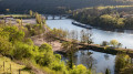
(2) At the end of the bridge, turn left and, after about twenty metres, go behind the guardrail on your left to retrace your steps slightly and go down the metal staircase. At the bottom, go under the bridge to join a riverside path, created in 2020–2021 by the hands of generous volunteers committed to the common good. Follow this path along the banks of the Moselle for 850 metres and you’ll soon reach the Château de la Flie.
(3) Follow the path along the water’s edge and, after 100 metres, you have a choice:
- either turn left onto a path that climbs up to pass close to the River Flie (off-limits during the hunting season); a well-maintained path takes you to the banks of the Eaux Bleues.
- or, to stay on the walk described here and follow a more scenic path accessible all year round, continue along the narrow path beside the Moselle. This section of the route, too, was hard-won by a group of volunteers. The path runs as close to the water as possible; where this isn’t possible, it climbs and descends via a few steps to get past obstacles until it joins the track leading to the Domaine des Eaux Bleues.
(4) The path passes under the railway viaduct (offering a lovely view of Liverdun) and then runs alongside the Domaine des Eaux Bleues.
(5) Don’t miss the small path that branches off to the right and runs along the Moselle to the Aingeray Lock.
(6) Then turn right to cross the lock bridge and join the Moselle Circular Greenway by turning right again.
(7) After about 800 metres, take the short path leading up to the road, cross it and follow the steep, stony path opposite (a rope on the right provides support on the rocky section). Then continue, following the red and blue three-stripe markings.
(8) After about 400 metres, at the junction, turn right (red marker) towards the Pelouses calcaires Sensitive Natural Area, where several species of orchids bloom in spring. As you emerge from the forest, turn left to head down the path , which offers stunning views of the village of Liverdun. At the bottom, you’ll come out near the Liverdun cemetery.
(9) Follow the road to the left leading towards the village and a three-way junction.
(10) At the crossroads, take the road on the right towards the Domaine du Val Fleuri (café and restaurant). Shortly afterwards, you’ll see the entrance to the tunnel of the old canal that runs beneath the village. Follow the ramp which leads you onto the steep Gargouille path. At the top, you’ll come out onto the road; turn right onto it and follow it to the junction opposite the Porte Haute of the medieval village.
(11) At the ‘Stop’ sign, take the road on the left, walk past the Notre-Dame de Bel Amour Chapel, then turn left again onto the pavement until you reach the bus stop, where you cross the road and head up to the entrance to the forest on your right. You’ll soon begin a fairly steep descent at a place called La Roche Barbotte. Use the rope on the rocky section to secure yourself. At the bottom, you’ll come out onto the Chemin du Tir.
(12) Turn right to follow it downhill. After about 400 metres, take the steps on your right to reach the exit of the canal tunnel you saw earlier.
(13) Follow the old canal cutting back to your car park (S/E).


 Tourism professional
 Easy
Easy 
 Visorando Member

 Association / Club / Walk leader