Oppedette Gorges - Le Calavon

Wild and difficult to access gorges, between 150 and 200m deep, very narrow in places, only a few metres wide. The descent of the Karstic Cave is very well equipped but tricky to navigate.

Details

542937
Creation:
Last update:
Last review:
  • Walking
    Activity: Walking
  • ↔
    Distance: 5.25 km
  • ◔
    Average duration: 2h 15 
  • ▲
    Difficulty: Moderate

  • ⚐
    Back to start: Yes
  • ↗
    Ascent: + 263 m
  • ↘
    Descent: - 254 m

  • ▲
    Highest point: 528 m
  • ▼
    Lowest point: 401 m

Photos

Description of the walk

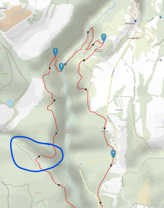
Park at the Grand Vallat car park on the edge of the D201.

(S/E) Cross the bridge and take the path immediately on the right. Ignore the paths on the left and right and keep heading north as you climb up the Gorges d'Oppedette. Continue for about 2.5 km until you reach the Aven de l'Échelle.

(1) Turn right to take the iron ladder, which is very sturdy; it is more like a staircase. The descent that follows is difficult but there are solid handrails to hold on to.

(2) Cross the river and head north-east for about 350m, then turn right onto the path that climbs up to the viewpoint. The climb is tricky but the handrails ensure your safety. You will arrive at the ridge at the Belvédère car park.

(3) Turn right, then right again 20 metres further on onto theGR®97(white and red markings). Follow this path to the D201.

(4) Cross the road and continue straight ahead on theGR®. Follow the departmental road for about 150m, cross it, then rejoin it one last time just before the car park. Turn right to return to the car park (S/E).

Waypoints

  1. S/E : km 0 - alt. 421 m - Grand Vallat car park
  2. 1 : km 2.24 - alt. 504 m - Karstic cave
  3. 2 : km 2.36 - alt. 433 m - Crossing the Calavon
  4. 3 : km 3.01 - alt. 528 m - Belvédère car park, GR on the right
  5. 4 : km 3.97 - alt. 498 m - D201, opposite
  6. S/E : km 5.25 - alt. 421 m - Grand Vallat car park

Notes

This hike includes a few tricky sections, but these are well equipped for safety. You should remain vigilant at all times.

Worth a visit

Geocaching: one cache in the village of Oppedette, another on the return trail.

 Always be cautious and plan ahead when you're outdoors. Visorando and the author of this route cannot be held responsible for any accidents occurring on this route.

The GR® and PR® markings are the intellectual property of the Fédération Française de Randonnée Pédestre.

Reviews and comments

4.6 / 5
Based on 34 reviews

Reliability of the description
4.5 / 5
Ease of following the route
4.4 / 5
Route interest
4.9 / 5
LE CORNEC Daniel
LE CORNEC Daniel

Overall rating : 4.3 / 5

Date of your route : Nov 17, 2025
Reliability of the description : ★★★★☆ Good
Ease of following the route : ★★★★☆ Good
Route interest : ★★★★★ Very good
Very busy route : Yes

I thought that the hikes published on Visorando should not have been previously published in other media? The Gorges d'Oppette hike has already been published for a long time in various IGN, PNRL and other guidebooks, with or without the descent via the ladder. So???

Machine-translated

[oɳƴ✗]
[oɳƴ✗]
• Edited:

Overall rating : 4 / 5

Date of your route : Oct 13, 2025
Reliability of the description : ★★★★☆ Good
Ease of following the route : ★★★☆☆ Average
Route interest : ★★★★★ Very good
Very busy route : Yes

A great, fairly technical hike. We came across some walkers with a dog and it was very difficult for the poor thing. I wouldn't recommend this hike with a dog or very young children (the section where you descend and then climb back up the gorges is quite similar to a via ferrata).

We went off-trail at one point well before reaching point 1. When we arrived at the dotted hairpin bend, we realised we were no longer on the trail. Trying to get back on track by taking the gorges was a nightmare because we had to climb back up through the woods, completely off-trail, to find a passable and marked path.

https://i.postimg.cc/Rhgd1W15/ranod1.png

CONCLUSION: stay on the marked trail

When you leave the gorges, don't hesitate to turn left, leaving the belvedere car park on your right, and take the road to the charming village of Oppedette.

.

Machine-translated

Gilmarche
Gilmarche
• Edited:

Overall rating : 3.7 / 5

Date of your route : Sep 07, 2025
Reliability of the description : ★★★☆☆ Average
Ease of following the route : ★★★☆☆ Average
Route interest : ★★★★★ Very good
Very busy route : No

Please note! This is a very beautiful hike, but longer (closer to 8 km, 3½ hours for two hikers in good physical condition) and more difficult than generally indicated.
You need to be in good physical condition, have good footwear and not be afraid of heights. Some sections are more like climbing than hiking.
Much of the route is covered with protruding or broken stones.
Do not take children (the "via Ferrara" section requires the ability to hold onto iron bars), or dogs.
It's a wonderful discovery but not an easy walk 😅

Machine-translated

a.bouvier91@orange.fr

Overall rating : 4.3 / 5

Date of your route : Aug 29, 2025
Reliability of the description : ★★★★☆ Good
Ease of following the route : ★★★★☆ Good
Route interest : ★★★★★ Very good
Very busy route : Yes

Quite a difficult and physically demanding hike despite the low elevation gain and short length.
The path on the right bank is difficult due to protruding rocks.
The crossing of the Calavon is slippery and uncomfortable
even in good weather if it has rained recently, as
the rock and ironwork do not dry quickly at the bottom.
I would not recommend this hike for children.

Machine-translated

lebob71
lebob71

Overall rating : 4.7 / 5

Date of your route : Aug 05, 2025
Reliability of the description : ★★★★★ Very good
Ease of following the route : ★★★★☆ Good
Route interest : ★★★★★ Very good
Very busy route : No

Magnificent hike...

Machine-translated

gerardcoquet
gerardcoquet

Overall rating : 4.3 / 5

Date of your route : Jan 06, 2025
Reliability of the description : ★★★★☆ Good
Ease of following the route : ★★★★☆ Good
Route interest : ★★★★★ Very good
Very busy route : No

Very beautiful hike with one tricky section but very interesting overall

Machine-translated

patrick55
patrick55
• Edited:

Overall rating : 5 / 5

Date of your route : Jan 06, 2025
Reliability of the description : ★★★★★ Very good
Ease of following the route : ★★★★★ Very good
Route interest : ★★★★★ Very good
Very busy route : No

A lovely hike, but be aware that it is a little technical (the difficult sections are well secured). Definitely do this in dry weather.

Machine-translated

verodomi
verodomi

Overall rating : 5 / 5

Date of your route : Aug 18, 2024
Reliability of the description : ★★★★★ Very good
Ease of following the route : ★★★★★ Very good
Route interest : ★★★★★ Very good
Very busy route : No

A very beautiful hike. The scenery is varied and impressive. The difficult sections for descending into the gorge and climbing back up are very well equipped (metal ramps and steps firmly fixed into the rock). However, we do not recommend this hike with young children. On the way back up from the gorge, we recommend a detour to the village of Oppedette and its small restaurant, La Planche à Pain. We had an excellent salad there and the owner is very friendly.

Machine-translated

Sylvie SD
Sylvie SD
• Edited:

Overall rating : 5 / 5

Date of your route : May 11, 2024
Reliability of the description : ★★★★★ Very good
Ease of following the route : ★★★★★ Very good
Route interest : ★★★★★ Very good
Very busy route : No

A beautiful, varied and spectacular route.
It is rocky, yes, but the beauty of the rocks, characteristic of sharp limestone pavements and karst geology, adds to the overall interest.

Machine-translated

jjmangier
jjmangier

Overall rating : 4.7 / 5

Date of your route : Apr 01, 2024
Reliability of the description : ★★★★★ Very good
Ease of following the route : ★★★★☆ Good
Route interest : ★★★★★ Very good
Very busy route : No

We went hiking the day after a very rainy night and were unable to descend into the canyon (we were hiking with a dog and the descent via the ladder was too difficult, plus the trail was flooded by a stream). We therefore continued along the trail (the passage immediately after the opening of the karstic cave is tricky) hoping to cross the ford at the beginning of the gorge north of Oppedette, but the current and water level were too high. We therefore continued and rejoined the road to Apt and crossed the Coulon on the road bridge. We climbed back up to Oppedette and rejoined the circuit at point 3.
This hike offers splendid scenery but you need good shoes (some parts of the trail are very rocky) and a head for heights.

Machine-translated

Valjo
Valjo

Overall rating : 5 / 5

Date of your route : Nov 03, 2023
Reliability of the description : ★★★★★ Very good
Ease of following the route : ★★★★★ Very good
Route interest : ★★★★★ Very good
Very busy route : No

Accurate description, beautiful walk, only the time taken is a little longer than stated. Be careful with the weather though, as you have to cross the river and if it has rained heavily it will be difficult. Otherwise, a great experience, no particular difficulties, but not suitable for children under 10 or 11...
The climb back up is superb!

Machine-translated

Zou56
Zou56

Overall rating : 4.3 / 5

Date of your route : Aug 09, 2023
Reliability of the description : ★★★★☆ Good
Ease of following the route : ★★★★☆ Good
Route interest : ★★★★★ Very good
Very busy route : No

Great hike! But not exactly a walk in the park!
I had read the comments saying it wasn't easy, but I hadn't realised how difficult it would be.
The start is easy, with a path covered in large rocks, so you need good shoes, but overall it's fairly easy and the view is fantastic! Then comes the "ladder", which is still very accessible... After that, it gets more complicated and you need good shoes and to take your time coming down, but at the bottom it's really nice and cool in summer!
The climb back up requires you to be physically fit and comfortable with your body as there are some small climbs at times! We had a great time with a 10-year-old who was very (very) physically fit!

Machine-translated

Valentinfelix
Valentinfelix

Overall rating : 4.7 / 5

Date of your route : Aug 07, 2023
Reliability of the description : ★★★★★ Very good
Ease of following the route : ★★★★☆ Good
Route interest : ★★★★★ Very good
Very busy route : No

Superb hike, highly recommended
Be aware that the route takes 3 hours and 15 minutes without lingering, with a challenging and steep descent after passing the ladder... After the very unusual experience of passing through the dry gorges, the climb back up is also very steep
Nevertheless, the landscape is wonderful and typical of the region, highly recommended 😉

Machine-translated

Guibo85
Guibo85

Overall rating : 4.7 / 5

Date of your route : Jul 31, 2023
Reliability of the description : ★★★★★ Very good
Ease of following the route : ★★★★★ Very good
Route interest : ★★★★☆ Good
Very busy route : No

We did this tour at the end of July. It was hot, but most of the route is in the shade or even cool in the gorges.
The whole family (children aged 11 and 14) really enjoyed the route.
We continued from the viewpoint to the village of Oppedette, which is 5 minutes away and well worth a visit! It is a very well-preserved and maintained old village, very picturesque.
This hike deserves 5 stars with the visit to the village!
Thank you to the author.

Machine-translated

magali gamon
magali gamon

Overall rating : 5 / 5

Date of your route : Oct 01, 2022
Reliability of the description : ★★★★★ Very good
Ease of following the route : ★★★★★ Very good
Route interest : ★★★★★ Very good
Very busy route : No

a pleasant hike that was exactly as described. We passed through the beautiful village of Oppedette where we had a bite to eat in a little bar...
Would recommend without hesitation

Machine-translated

Other walks in the area

For more walks, use our search engine .

The GPS track and description are the property of this route's author. Please do not copy them without permission.