Puilaurens Grotte cliff (climbing routes) – round trip

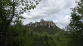
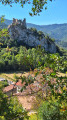
This route describes the access path to the cliff face at the Serre de la Quière climbing site above the village of Puilaurens. It is not a hike in its own right but is intended to facilitate climbers’ access to this magnificent cliff face. The view is splendid, overlooking the castle, the forests and the Pic Dourmidou.

Details

89339223
Creation:
Last update:
Last review:
  • Walking
    Activity: Walking
  • ↔
    Distance: 0.45 mi
  • ◔
    Average duration: 0h 30 
  • ▲
    Difficulty: Easy

  • ⚐
    Back to start: Yes
  • ↗
    Ascent: + 354 ft
  • ↘
    Descent: - 354 ft

  • ▲
    Highest point: 2,149 ft
  • ▼
    Lowest point: 1,795 ft

Description of the walk

Park in the small car park located at a bend in the road.

(S/E) Walk back up the road for about twenty metres, then take the small path on the left which follows the fence line. It winds its way, sometimes in the open and sometimes through the undergrowth, towards the cliffs, which are visible from the start of the path. See Practical Information for access to the various climbing sectors.

(1) Follow the route back in the opposite direction to return to the car park (S/E).

Waypoints

  1. S/E : mi 0 - alt. 1,795 ft - Car park
  2. 1 : mi 0.01 - alt. 1,801 ft - Start of the path
  3. 2 : mi 0.22 - alt. 2,149 ft - Grotte de Maître Jean sector
  4. S/E : mi 0.45 - alt. 1,795 ft - Car park

Notes

Access to the Dalles sector: about ten metres before the Grotte de Maître Jean sector, the path veers left and descends slightly.

Access to the Cœur de Ciel sector: follow the path that runs alongside the Grotte de Maître Jean sector to the right, then head down a faint earthen track without veering too far to the left. Once level with the cliff, cross the scree horizontally to the foot of the routes.

Other walks in the area

For more walks, use our search engine .

The GPS track and description are the property of this route's author. Please do not copy them without permission.