Country:

 City:
City:


Park in the car park by Saint-Martin’s Church.
(S/E) Leaving the car park, turn left and walk past the church entrance. At the crossroads, continue straight ahead, then at the tree in the centre of the junction, turn left towards Fonbigou. After 100 m, take Impasse du Puy on the right. After a short climb, take the steps on the left and walk alongside the building. At the crossroads, turn right and continue until you reach the tarmac road to Royère.
(1) Turn left, then after 100 m, turn right onto Impasse du Moulin à Vent. After about thirty metres, follow the path to the left, rejoin the tarmac road and turn right towards Laborie. Once you reach the hamlet, take the path leading down to the right to the wash house.
(2) Retrace your steps and follow the road for about 100 metres to the right. Then turn left (yellow markings) and head uphill to the junction with a cross-path. First turn left then right and head downhill to the next junction, situated below Lemboucade.
(3) Head left, leaving the yellow-marked circular loop behind, and walk amongst the walnut trees and then through a hedge of trees. At the crossroads, turn left and then right at a small pond to reach Fonbigou.
(4) Head downhill to the left and, at the bottom, turn left again to reach the Fonbigou washhouse.
(5) Turn back, then rejoin the route by heading uphill to the left until you reach the crossroads by the wayside cross. Turn right onto the plateau and join a tarmac road: the rugged terrain ends here.
(6) Follow it to the left, then turn right about fifty metres further on. Continue across the plateau, skirting the walnut groves, until you reach the Laveyssière junction.
(7) Head down to the left. After 200 m, at the crossroads by the walnut groves, turn left and walk on until you reach the tarmac road (D70).
(8) Follow it carefully to the left. At the second bend, take the path on the right to reach the Fongoudou washhouse: even during droughts, there has always been water here.
(9) Return to the road and turn right to reach the village of Granges d’Ans. Once in the centre, turn right to walk past the church and back to the car park (S/E).
 Visorando Member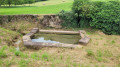
 Easy
Easy