


From Castell Montgri Campsite to Cala Montgo


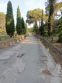
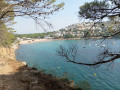
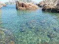
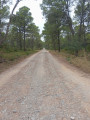
Hike starting from the Castel Montgri campsite. The start is quite a steep climb, with lovely views of L’Estartit and its beach. The path leads onto the GR® 92. It’s an easy path as far as Cala Montgo, then you need to take the path leading to Punta Ventosa, which is a bit more challenging. The paths are still not clearly marked. Make sure you wear sturdy walking shoes for this hike, which offers views of beautiful coves.
Details
Creation:
Last update:
Last review:
–
–
-
 Activity: Walking
 -
 Distance: 12.85 mi
 -
 Average duration: 7h 00
 -
 Difficulty: Difficult
 -
-
 Back to start: Yes
 -
 Ascent: + 1,273 ft
 -
 Descent: - 1,286 ft
 -
-
 Highest point: 554 ft
 -
 Lowest point: 0 ft
-
 Country:
Spain
Country:
Spain
-
 City:
Torroella de Montgrí
City:
Torroella de Montgrí -
 Start/End: N 42.051088° / E 3.183285°
 -


 Hour-by-hour weather


Photos
Waypoints
- S/E : mi 0 - alt. 26 ft - Campsite
- 1 : mi 1.24 - alt. 135 ft - Fork
- 2 : mi 1.44 - alt. 226 ft - Junction
- 3 : mi 2.26 - alt. 440 ft - Fork
- 4 : mi 4.66 - alt. 338 ft - Junction
- 5 : mi 6.61 - alt. 16 ft - Cala Montgo
- 6 : mi 7.22 - alt. 75 ft - Cova dels Crestats
- 7 : mi 7.69 - alt. 164 ft - Cova de la Sal
- 8 : mi 11.1 - alt. 374 ft - Torre Ponca
- S/E : mi 12.85 - alt. 23 ft - Campsite
Other walks in the area
Calanque Ferriol (Cala Ferriol) in Estartit
 Visorando Member
 5.82 mi
+1,365 ft
-1,362 ft
3h 50
5.82 mi
+1,365 ft
-1,362 ft
3h 50
 Moderate
 Departure from Torroella de Montgrí (Girona)
Explore two calanques (Cala in Spanish) around Estartit. A pleasant walk with superb views. A route taking in the beautiful Mediterranean Sea, the pine forest and the rocks. Stunning panoramic views from the heights before descending into the calanques.
From L’Estartit to Cala Calella and back
2.58 mi
+551 ft
-545 ft
1h 40
 Easy
Departure from Torroella de Montgrí (Girona)
Easy
Departure from Torroella de Montgrí (Girona)
This route allows you to get away from the beaches and the hustle and bustle of the seaside resort of L’Estartit, taking you along cliffs with stunning views of Roca Maura, the Medes Islands and the rugged coastline. The stony, sometimes uneven path leads to Cala Calella, a small, beautiful cove where swimming is a pleasure.
Castell Mongri and the Santa Caterina Hermitage circular
 4.88 mi
+1,194 ft
-1,194 ft
3h 20
Difficult
Departure from Torroella de Montgrí (Girona)
4.88 mi
+1,194 ft
-1,194 ft
3h 20
Difficult
Departure from Torroella de Montgrí (Girona)
This typically Mediterranean circular in the Montgrí Illes Medes i Baix Ter Natural Park alternates between open heath landscapes and wooded areas.
Montgri Castle, built in the 13th century, dominates the entire region and offers spectacular views.
The Hermitage of Santa Caterina, founded by hermits in the 14th century, is an ideal place to take a break from the hustle and bustle of everyday life in a place steeped in history, celebration and encounters.
Please note: this is a demanding route, suitable only for walkers accustomed to uneven and stony terrain. Please read the Practical Information section carefully.
Castell Montgri
 4.74 mi
+1,293 ft
-1,293 ft
3h 20
Difficult
Departure from Torroella de Montgrí (Girona)
4.74 mi
+1,293 ft
-1,293 ft
3h 20
Difficult
Departure from Torroella de Montgrí (Girona)
Tour above Torroella to Castle of Montgri, via Montplà and Garrigars pass.Superb 360° panorama.
Caution : not very accessible with children, as you have to do a lot of scrambling in the rocks, and there's a steep section in a scree slope.
Tour of the Montgrí Massif
 6.30 mi
+1,929 ft
-1,906 ft
4h 35
Difficult
Departure from Torroella de Montgrí (Girona)
6.30 mi
+1,929 ft
-1,906 ft
4h 35
Difficult
Departure from Torroella de Montgrí (Girona)
Want to get away for a few hours and discover one of the most iconic panoramas of the Costa Brava?This hike in the heart of the Montgrí Massif in the Montgrí, Medes Islands and Baix Ter Natural Park will immerse you in a wild landscape, where the Mediterranean Sea reveals itself at every ridge and where the hermitage of Santa Caterina has stood silently for centuries. With the scent of rosemary in the air and incredible views of the Pyrenees and the Medes Islands, this route offers everything we love: peaks to climb, unspoilt nature, heritage and a sense of freedom. All you have to do is put on your walking boots... and let yourself be surprised.Please note: this is a demanding route, suitable only for walkers accustomed to uneven and stony terrain. Please read the Practical Information section carefully. The Visorando app is recommended.
From Montgó Beach to Port de l'Escala in a circular route
3.09 mi
+177 ft
-174 ft
1h 35
Easy
Departure from l'Escala (Spain)
Set off from Montgó Beach for a spectacular circular walk. Follow the GR®92 to Port de l'Escala, with breathtaking views, and return through the narrow streets steeped in history. A walk between sea and heritage.
Sa Punta and Cala Aiguafreda via the Cami de Ronda
 8.06 mi
+1,713 ft
-1,726 ft
5h 10
Difficult
Departure from Begur (Girona)
8.06 mi
+1,713 ft
-1,726 ft
5h 10
Difficult
Departure from Begur (Girona)
This loop starting from Sa Riera initially runs through woodland and leads to the pretty site of Torre de Mas d'en Pinc at the entrance to Begur. You quickly cross the eastern residential areas before rejoining the Cami de Ronda. This trail runs along a balcony offering magnificent views and leads to Cala Sa Punta, then to Cala Aiguafreda, two discreet and idyllic spots for swimming in the summer. The final section also offers many other opportunities for swimming from the easily accessible rocks along the coast. Despite the distance, the real difficulty of this hike should not be underestimated, as it can be tricky to find your way due to the large number of unmarked paths and several very steep ascents and descents that will leave you breathless and your legs aching.
Travel back in time from the Greeks to the Romans in Escala
2.55 mi
+112 ft
-236 ft
1h 15
Easy
Departure from l'Escala (Spain)
Starting from L'Escala, a magnificent hike leads to some exceptional and surprising Greco-Roman ruins. For €6, you can enjoy a comprehensive tour lasting nearly two hours with an audio guide on your smartphone. A real favourite!
For more walks, use our search engine .
The GPS track and description are the property of this route's author. Please do not copy them without permission.

