Dourdan – Sainte-Mesme

A total immersion in the Dourdan State Forest, where oak is the dominant tree species. There are also chestnut, ash, beech and birch trees. In some sandy areas, these are replaced by pine trees. The legend of Sainte-Mesme and the medieval heritage of Dourdan.

Details

28377846
Creation:
Last update:
Last review:
  • Mountain biking
    Activity: Mountain biking
  • ↔
    Distance: 12.45 mi
  • ◔
    Duration according to the author: 2 hrs 
  • ▲
    Difficulty: Difficult

  • ⚐
    Back to start: Yes
  • ↗
    Ascent: + 538 ft
  • ↘
    Descent: - 522 ft

  • ▲
    Highest point: 525 ft
  • ▼
    Lowest point: 308 ft
  • ⚐ Country: France
  • ⚐ City: Dourdan (91410|91870)
  • ⚑
    Start/End: N 48.527157° / E 2.012117°
  • ❏
    IGN map(s): Ref. 2216ET

  • ◶
    Type of surface:
  •  
     
     
     33% Road  34% Byway  33% Path
  • ⇧
    Bike carrying: No
  • ▲
    Difficulty: Difficult
  • Hour-by-hour weather

Photos

Description of the route

The starting point is in Dourdan, on Rue Jubé de la Pérelle, at the car park. This is opposite the George Leplatre Primary School and the Jeanne d’Arc Secondary School, and next to a basketball court. From Paris, you can take the TER or the RER C. From the north or west of Paris, take the RER C. On arrival at Dourdan station, you can join the route via Rue du Faubourg de Chartres.

(S/E) On leaving the car park, turn right onto Rue Jubé de la Pérelle. At the T-junction, turn left onto Rue d’Étampes, then continue along Rue Demetz, which is a continuation of Rue d’Étampes.

(1) When you reach Place du Général de Gaulle, opposite the château, turn left onto Rue du Marché aux Grains, following the direction of traffic. At the second junction, turn right onto Rue Haute Foulerie. Pass Rue de l’Abreuvoir on your right and, at the next junction, turn right onto Rue du Moulin du Roi.

(2) At the T-junction, turn right onto Boulevard Émile Zola and, at the next junction, turn left onto Rue du Faubourg de Chartres. Continue to the roundabout.

(3) Turn right onto Rue de Rambouillet. Go under the railway line and, immediately afterwards, turn left onto Chemin des Buttes Blanches. After about 200 m, turn right onto Route des Buttes Blanches. At the next two junctions, continue straight ahead.

(4) At the three-way junction, take the left-hand lane, which curves to the left, and continue along it until you reach the junction with Route de la Pie.

(5) Turn left onto Route de la Pie, go past the next junction and carry on straight ahead. At the next junction, turn right and carry on until you reach the Carrefour du Beau Rouvre.

(6) Turn sharply left onto Route de Marcoussis and, after about 200 m, take a hairpin bend to the right onto Route du Gros Chêne, continuing without leaving the road. At the Carrefour Antonine, carry on straight ahead until you reach the next junction.

(7) Turn left onto Route de la Jumelle and, at the junction with Route du Cordon, carry on straight ahead. At the T-junction, turn right and follow the windingPR® path. At the junction with Route de Bonchamp, follow the path which veers to the right and joins a path on the left.

(8) Turn left onto Route du Cordon, continue to the Denisy junction without leaving the track, then turn left onto Route de Denisy. Leave the forest and reach a junction of roads.

(9) Turn left and continue along Route de Denisy. Pass through the hamlet of Denisy and carry on straight ahead. At the Y-junction, take the right-hand track and continue to the village of Sainte-Mesme.

(10) At the junction, carry on straight ahead into the village of Sainte-Mesme, along Rue du Buisson. When you reach the junction with the D168, turn left onto Rue Fernand Laigneau. Carry on straight ahead along Rue Charles Legaigneur, which is a continuation of the same road. This road curves to the right; carry on until the next junction.

(11) Carry straight on along Route de Corbreuse, go under the railway line and, immediately afterwards, turn left onto Voie Le Moulin du Pré. Carry straight on without leaving this road.

(12) When you reach the village of Ville Lebrun, and a good fifty metres before the junction with Route de Dourdan, turn right onto Route des Sept Buttes and carry on straight ahead until you reach the next crossroads, where you’ll find a picnic area.

(13) Turn left onto Chemin de la Queue d’Auneau. At the Carrefour du Sauvage, turn right onto Route du Président and carry on straight ahead. Cross the D5 , taking care of the traffic, and continue straight on to the next T-junction.

(14) Turn left and, at the Y-junction, take the left-hand lane, Route de l’Ouye. Continue along Chemin des Abbesses, which forms a continuation of this road, until you reach Avenue d’Orléans, the D116.

(15) Continue straight on along Rue de l’Ouye and, at the T-junction, turn right onto Rue de Balzac. At the end of the street, turn left onto Rue Victor Hugo, then left again onto Rue Jules Ferry. At the next junction, turn right, then right again onto Rue Saint-Jacques.

(16) At the roundabout, takethe second lane on the left onto Rue d’Étampes. At the next junction, carry straight on along Rue d’Étampes, which curves to the left. Continue along Rue Demetz, which is a continuation of Rue d’Étampes. You will arrive at Place du Général de Gaulle.

(1) Opposite the château, turn left onto Rue du Marché aux Grain and continue straight on along Rue de l’Abbé Gérard. At the T-junction, turn left onto Rue Jubé de la Pérelle and, after about 150 metres, turn right to return to the car park (S/E).

Waypoints

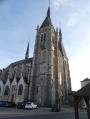
  1. S/E : mi 0 - alt. 312 ft - Car park on Rue Jubé de la Pérelle - Église Saint-Germain-d'Auxerre (Dourdan)
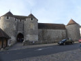
  2. 1 : mi 0.28 - alt. 344 ft - Place du Général de Gaulle - Château de Dourdan
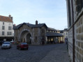
  3. 2 : mi 0.46 - alt. 318 ft - Boulevard Émile Zola - Halle de Dourdan
  4. 3 : mi 1.05 - alt. 364 ft - Rue de Rambouillet. - Château du Mesnil
  5. 4 : mi 1.71 - alt. 436 ft - T-junction, turn left - Gare de Dourdan-la-Forêt
  6. 5 : mi 2.04 - alt. 400 ft - Route de la Pie
  7. 6 : mi 2.55 - alt. 489 ft - Beau Rouvre crossroads
  8. 7 : mi 3.74 - alt. 518 ft - Route de la Jumelle - Église Sainte-Mesme (Sainte-Mesme)
  9. 8 : mi 5.01 - alt. 495 ft - Route du Cordon
  10. 9 : mi 5.84 - alt. 423 ft - Route de Denisy
  11. 10 : mi 6.98 - alt. 427 ft - The village of Sainte-Mesme - Fontaine de Saint-Mesme
  12. 11 : mi 7.78 - alt. 351 ft - Route de Corbreuse - Manoir de Sainte-Mesme
  13. 12 : mi 8.27 - alt. 367 ft - Route des Sept Buttes - Orge (l')
  14. 13 : mi 8.83 - alt. 512 ft - Grillon Labyrinthe trail, car park
  15. 14 : mi 10.21 - alt. 377 ft - T-junction, turn left - Abbaye Notre-Dame de l'Ouye
  16. 15 : mi 11.32 - alt. 381 ft - Avenue d’Orléans, D116
  17. 16 : mi 11.93 - alt. 315 ft - Rue d’Étampes - Halle de Dourdan
  18. S/E : mi 12.45 - alt. 312 ft - Car park on Rue Jubé de la Pérelle

Notes

Picnic areas: just before (7), at Carrefour Antonin and at (13).

Shelter available at (13).

The route is likely to be very muddy after a spell of rain.

There are no water points along the route. Look for them in the hamlets and villages you pass through.

No special equipment is required, other than that needed for mountain biking.

Worth a visit

(1) In Dourdan: the Château – La Halle – Saint-Germain-d’Auxerre Church.

Between (6) and (7), at the junction with the Chemin de Sainte-Mesme, the ‘Chêne Foudroyé’ (the Oak Struck by Lightning).

(10) In Sainte-Mesme: the Fountain and its legend, the Manor House and its museum of military costume. Also see, at the Town Hall, the story of Auguste Jules Maquet, Lord of Sainte-Mesme. He was a man of letters, a poet, playwright and novelist. He was a friend and collaborator of Alexandre Dumas, notably on the writing of *The Three Musketeers* and *The Count of Monte Cristo*.

(13) The Parcours du Grillon, a maze and discovery trail, 250 metres long and fully accessible to people with reduced mobility. It was created by the ONF.

Always be cautious and plan ahead when you're outdoors. Visorando and the author of this route cannot be held responsible for any accidents occurring on this route.

The GR® and PR® markings are the intellectual property of the Fédération Française de Randonnée Pédestre.

Reviews and comments

4.3 / 5
Based on 2 reviews

Reliability of the description
4.5 / 5
Ease of following the route
3.5 / 5
Route interest
5 / 5
gillesmoretto
gillesmoretto

Overall rating : 4 / 5

Date of your route : Dec 03, 2022
Reliability of the description : ★★★★☆ Good
Ease of following the route : ★★★☆☆ Average
Route interest : ★★★★★ Very good
Very busy route : No

Discover Dourdan in a different light; explore unusual places such as the wash houses, the banks of the River Orge, the medieval quarter and its castle.

Machine-translated

FTALLON
FTALLON

Hello,
What’s more, at this time of year, with the autumn colours, it’s absolutely lovely.
Thank you for your attention

Machine-translated

monique92
monique92

Overall rating : 4.7 / 5

Date of your route : Dec 03, 2022
Reliability of the description : ★★★★★ Very good
Ease of following the route : ★★★★☆ Good
Route interest : ★★★★★ Very good
Very busy route : No

The map wasn’t always easy to follow.
But all the participants thought this walk was brilliant
Thank you so much!!!

Machine-translated

Other walks in the area

For more walks, use our search engine .

The GPS track and description are the property of this route's author. Please do not copy them without permission.