Country:
 City:
City:


Starting point and access: Guillerval station
- TER - Commuter service between Paris-Austerlitz and Orléans.
The exit is at the rear of the train if arriving from Paris towards Orléans (platform 1), and at the front of the train if arriving in the opposite direction (platform 2). There is no designated crossing to get across the tracks.
No signposting
(S) The start of the route, upon exiting Guillerval station, depends on which platform you alight from:
- Track 1 (from Paris to Orléans) – As shown on the map, turn right and cross a small car park. At the far end, go down a flight of steps. You’ll come out onto a road (Voie de Chalou-Moulineux); follow it to the right and pass under the railway line, keeping to the right-hand verge (the left-hand one is too narrow). After about a hundred metres, you’ll reach the junction with the access road to the car park on the Track 2 side.
- Track 2 (Orléans to Paris direction) - Cross the road to follow Rue de la Gare, which quickly joins the main road.
(1) Follow the road westwards , taking great care (narrow verges). Pass under a medium-voltage power line and, about a hundred metres further on, you’ll reach a junction.
(2) Then turn right towards the Ferme de Chicheny and walk alongside the building on your left. At the gate, the tarmac gives way to a gravel track. At the far end of the building, ignore a turning area on the left and continue along the track for some time, heading north-north-east.
(3) At the first junction, head diagonally left towards the smallest of the nearby copses. At the next junction (elevation 144), turn left. Walk alongside a copse on your right, then enter it. Shortly afterwards, walk alongside a fallow field on your left and you’ll soon reach a junction.
(4) Then turn right at the edge of a field on your left and a woodland on your right. Enter the woodland, head slightly downhill and ignore a path branching off to the right towards an abandoned hut. You’ll soon emerge onto a wide path and follow it to the left. The path curves to the right and leaves the woodland.
(5) At a three-way junction, turn right and head down a narrow valley between two woods. Further on, ignore a path on the right and turn left onto the main track. Head downhill and walk alongside horse pastures on your left. Ignore a track on the left and rejoin the tarmac road. You’ll soon reach a three-way junction.
(6) Follow the road to the left as far as the spillway of the Étang de Chalou-Moulineux (a lovely view of the pond, dominated by the bell tower of Moulineux church, and, in the distance, Chalou church). Retrace your steps back to the three-way junction.
Red and yellow markings
(6) Turn left onto a track marked ‘No Entry’, the Rue des Roches. At the Fork in the road just after a black gate on the left-hand side, turn left onto a path and walk alongside a wire fence. Further on, walk alongside a river on your left. Continue for a long stretch along the shaded path. Finally, walk alongside a trellis on your right.
(7) You’ll come out onto a track; follow it to the left and pass in front of the gate at No. 4. At the three-way junction that appears immediately, turn right onto a path. Go straight on and stay in the woods for a long while. You’ll reach the tarmac road when you come to the first houses.
Red and yellow + yellow markings
(8) Turn off to the right and walk past the large Boinville farmstead on your left. Shortly afterwards, at a Fork in the road, turn left. Cross a road and continue straight ahead along a stony track. Walk up the Vallée Vigneron, first along the edge of the woods then between a hedge on your left and a field on your right.
(9) At the top, at a T-junction, turn left and head north between fields and fallow land.
(10) After a short descent, you’ll come out onto a small road; follow it to the right. Walk past two sheds and, at the Fork in the road, turn left onto a grassy path. After about 300 m, turn left with the path and walk alongside a short, isolated hedge on your left.
Red and yellow markings
(11) At the next junction (wooden gate on the left), carry straight on, first between the fields and then with a hedge on your left.
No markings
(12) At the next junction (wooden gate on the left), turn sharply right and follow a grassy path between the fields. At the T-junction (not shown on the map), turn left. Ignore a path on the right and walk past a shed on your left. Continue along a gravel track dotted with patches of tarmac.
Yellow markings + MTB signpost no. 4
(13) After a short descent and as you come out of a left-hand bend, turn sharply right and follow a path along the edge of the woodland. Cross a patch of woodland then continue along the edge. Descend to a small road (with a shed some distance away on the right).
(14) Cross the road and head back up the stony track opposite. Continue along the edge of the woodland.
Mountain bike signpost no. 4
(15) At a junction (signpost; hunting post no. 5), go straight on. Descend quite steeply along the edge of the woodland.
(16) At the bottom, cross a track and follow a path that veers off to the left and climbs gently. You’ll come out onto a wide track; follow it to the left. Pass by a hunting hide on your right, then follow a hedge on your left.
No signposting
(17) At the end of the path, turn left onto a small road and head down a fairly steep slope.
(18) At the Stop sign, cross the D21 and follow a small road diagonally to the left towards the Domaine de Pierrefitte and the Château de Valnay. Walk downhill and, at a right-hand bend, pass in front of the château. Cross the bridge over the River Chalouette.
Red and yellow + yellow markings
(19) Turn immediately right and enter the Marais de Vaujouan estate. Walk for a long stretch in the shade, with the river on your right. Ignore a footbridge on the right. Then turn left with the path and move away from the river. Cross another river, the Louette.
(20) On the other side of the bridge, follow a track to the right which soon gives way to a tarmac lane. Carry on straight ahead between gardens and small houses. Ignore a turn-off to the right, then one to the left, and walk alongside the river on your right.
(21) You’ll come out onto a main road; follow it to the right and go under a railway bridge.
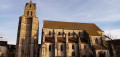
(22) Immediately turn right onto a footpath. Cross the Louette again. At the next junction, turn left onto Rue Philéas Vassal. At the end, first turn right then left onto Rue du Cimetière, which quickly leads to the foot of Saint-Martin’s Church (note its leaning bell tower, reminiscent of the Leaning Tower of Pisa – the underlying phenomenon is the same).
(23) Walk round the church on the right, keeping it on your left, go past its apse and you’ll come to a junction.
(24) Head straight ahead onto Rue de la Digue. Start by following a narrow cobbled section. When the street widens, continue winding through a residential area, ignoring the dead ends and side streets on either side. Pass under the railway bridge and you’ll immediately reach a junction on the banks of the Chalouette.
(25) Turn left and walk up a slope running parallel to Rue Salvador Allende. Then climb the steps on the left to reach Saint-Martin-d’Étampes station (E).
To return home:
- RER – Line C towards Juvisiy, Paris and Versailles.
 Visorando Member

 Difficult
 Easy
Easy