From one valley to another, starting from Flavigny-sur-Ozerain

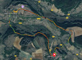
A circular route starting from the medieval town of Flavigny-sur-Ozerain, allowing you to explore, in part, the valleys of the Ozerain and the Oze and discover some of the restored historic buildings there. Make sure to set aside some time to wander around Flavigny and soak up its rich and varied cultural heritage.

Details

3835843
Creation:
Last update:
Last review:
  • Walking
    Activity: Walking
  • ↔
    Distance: 14.96 mi
  • ◔
    Average duration: 8h 15 
  • ▲
    Difficulty: Difficult

  • ⚐
    Back to start: Yes
  • ↗
    Ascent: + 1,526 ft
  • ↘
    Descent: - 1,526 ft

  • ▲
    Highest point: 1,529 ft
  • ▼
    Lowest point: 869 ft
  • ⚐ Country: France
  • ⚐ City: Flavigny-sur-Ozerain (21150)
  • ⚑
    Start/End: N 47.510822° / E 4.528697°
  • Accessible from the train station Gare de Thenissey.
  • ❏
    IGN map(s): Ref. 2921SB, 2922SB
  • Hour-by-hour weather

Description of the walk

Head to Flavigny-sur-Ozerain and park in the signposted public car park located along the D9 towards Venarey-les-Laumes and Alésia, in a circular bend near the garden below the town.

(S/E) From the car park, cross the D9 and climb the few steps opposite to find yourself near a picnic area, right next to the Porte Sainte-Barbe and the Abbaye restaurant. Enter the village through this gate and along Rue de l’Abbaye (immediately on the right, the aniseed factory and its museum). At the corner of the building, on the right, is the passage leading to the Abbey crypt (free entry). Follow Rue des Anciennes Halles, taking in the medieval buildings as you go. Carry straight on along Rue Crébillon, then Rue du Trop Chaud, which turns left.

(1) Turn right onto Rue du Bassin (a cul-de-sac). At the end of the street, it continues as a narrow lane running between the houses and the seminary walls. This leads out onto Rue Saint-Dominique. Look up at the house on the left to see a 15th-century Pietà. On the right-hand side of the street is the Seminary of the Holy Curé of Ars, formerly the Lacordaire house. Turn right onto Rue de la Porte du Val, dating from the 13th and 16th centuries, to leave the village. There’s a lovely view opposite.

(2) Turn right onto the gravel path leading downhill. At its junction with a tarmac road, turn right and continue downhill. Just before a wrecked blue van being used as a shelter for animals, turn left onto the path that winds down between two hedges. Cross the D9.

(3) Carry on straight ahead, passing the Ancien Moulin l’Abbé, cross the Ozerain stream and then, at the next junction of tracks, head straight up between the hedges. Pass under a medium-voltage power line, then regain some height on the slight rise before reaching a T-junction in the Bois des Roseaux (elevation 338 m). Turn right to follow the path leading out of the woods and continuing across the fields. When you reach the copse of trees on the left, turn right towards Sombernon and arrive at another copse.

(4) From this field path, turn right to catch a glimpse of Flavigny in the distance. Keep to the right as you enter the Bois d’Eugny and follow the wide, open path for a long, uninterrupted stretch. Ignore any side paths. At a gentle bend to the left, at the junction with a path leading out of the woods on the left, head straight to the right along the continuation of that path; after 30 metres, you’ll reach a small copse below (visible clearing – the path has disappeared, having been ploughed over).

(5) Descend slightly through the undergrowth and then cross the field along a clearly marked track. The path enters the woods again. It emerges with a field on the right, then turns left to continue across fields towards Sombernon. Upon reaching the edge of a wood, it turns right and follows the edge of the woodland. Pass under a high-voltage power line (viewpoint on the left). Continue straight ahead until you reach the only track branching off to the left through the woods. The path descends to join the D10e.

(6) Turn left onto this road and follow it downwards, taking care, until you reach the bridge over the railway line, just before Gissey-sous-Flavigny (from the higher ground, you can look out over the Oze valley). Alternative route (see practical information).

(7) Turn right before this bridge and follow the railway line all the way, keeping to the left until you reach Thenissey. However, a stop at the Ancien Moulin de la Serrée is a must. As well as open-air and covered picnic areas, the renovated building showcases key moments in the lives of families and individuals from the commune of Gissey. Free entry. Do make sure to have a look around. You enter Thenissey via Rue de la Serrée. Continue to Rue du Château.

(8) Turn right onto this street. Further on, on the left, you’ll see the gate to the property and a view of two castles from different periods. Continue carefully along the road, crossing the bridge over the River Oze and passing the wayside cross, then follow the main road uphill until you reach a track suitable for vehicles branching off to the left. There is a bench and a sign prohibiting 4x4 vehicles.

(9) Turn onto this track, which climbs steadily. Follow the main track, ignoring the numerous side tracks rutted by vehicle tracks. It passes under a high-voltage power line before crossing it again further on, diagonally, almost at the top of the hill. As you enter the woodland, keep to the right to continue along a track at the edge of the woods, running alongside another track that is largely rutted by 4x4 vehicles (pits over 2 m deep). At the far end of the woodland, the track turns left to continue along the edge. It winds its way through the woodland and is in better condition. Turn right at the first junction of tracks.

(10) There is a hunting hide here. Further on, the main track branches off to the right through the coppice and emerges into the fields. Continue straight ahead until you reach the junction with a dirt track. Turn left onto this track, which, 130 m further on, veers right to pass under a high-voltage power line. Continue straight ahead to reach a five-way junction at the edge of the woodland.

(11) Turn left onto the woodland path at the edge of the field; the signpost points to the right. It turns into a white stony track. This is the ancient Roman road leading to Alésia. On the left, take path 10 (blue paint on a tree) which leads to a flat rock from which there is a beautiful view of the horizon (caution: precipice with a steep drop). Retrace your steps and continue along the Roman road. The next path on the left leads to the Grotte du Maquis. The descent is steep but safe. You can walk along the secured rock face to climb back up further on and rejoin the Roman road.

(12) Shortly afterwards, at the crossroads of tracks, you’ll find milestone markers with an information board. Continue along the white path until it joins a tarmac road. Cross this road and continue straight ahead along the Roman road. Further on, follow the signs for Alésia, ignoring the left-hand turn-off for Hauteroche. The path then becomes tarmac and passes through the Murées d’Hautereilles crossroads (425m). It joins the D10e at the ancient site of Landran. Turn left. This is the junction for the alternative route (see practical information).

(13) Take the D10e with care, then turn right onto the first tarmac track. It passes under a medium-voltage power line before crossing the hamlet of Nailly. Head downhill and pass under a second power line before joining the D9. Carefully head right for about one kilometre to cross the Ozerain. Immediately after the bridge, turn left onto the tarmac track.

(14) Follow the road to its end at a T-junction, then turn right and shortly afterwards left to reach the hamlet of Le Colombier. When you reach the entrance to the farm, turn right, wade across the Ru de Verpant, and head straight up the rather steep path through the meadows, ignoring any side tracks.

(15) At the crossroads of tracks, with dry stone walls on the left, continue along the main path which turns left before veering right at the foot of the Saint-Jacob wall. It winds its way uphill, passing by a wayside cross dated (1803/1804) and 1862.

(16) After exiting through the main gate, enter via the small gate, known as the Poterne (15th century). Turn left to walk uphill along the ramparts and enjoy a panoramic view of the final stretch of the route taken from the hamlet of Nailly. At the end, you’ll come out at the Watchtower (15th century), with a 13th-century building opposite. Take Rue de l’Ancienne Cure, then turn left onto Rue de la Poterne towards the church (on the left is a house with a 16th-century stair turret and on the right is the Louis XII house with 16th-century windows). First turn left then right to follow Rue de l’Ancien Couvent and arrive at the entrance to Saint-Genest Church (13th and 15th centuries).

(17) From the church porch, turn left onto Rue de l’Hôtel de Ville, then left again onto Rue Mirabeau to arrive opposite Abel Labourey and its Millière fountain, fed by a spring tapped in 1864–1865. Continue along the Grande Rue, passing the Abbey of Saint-Joseph de Clairval – formerly the Hôtel Conthier de Souhey (17th century) – to reach the Porte du Bourg (15th century) with its old drawbridge (14th century). Once you have crossed it, turn right towards the war memorial and follow the tree-lined path. Pass to the right of the statue of Father Henri Lacordaire (1875). Go down the steps, cross the D9 and head for the car park further on to the left, down below (S/E).

Waypoints

  1. S/E : mi 0 - alt. 1,289 ft - Public car park on the D9 at Jardin-sous-la-Ville
  2. 1 : mi 0.29 - alt. 1,280 ft - Rue du Bassin (dead end)
  3. 2 : mi 0.49 - alt. 1,257 ft - Porte du Val in Flavigny-sur-Ozerain
  4. 3 : mi 1.02 - alt. 896 ft - Cross the D9 towards the old Abbé mill
  5. 4 : mi 1.71 - alt. 1,283 ft - Crossroads of trails
  6. 5 : mi 2.74 - alt. 1,398 ft - Crossroads of tracks at the edge of the woods
  7. 6 : mi 3.99 - alt. 1,201 ft - Junction with the D10e – possible alternative route
  8. 7 : mi 4.59 - alt. 958 ft - Turn right before the railway bridge
  9. 8 : mi 6.47 - alt. 968 ft - Thenissey – junction of Rue de la Serrée and Rue du Château - Oze (rivière)
  10. 9 : mi 6.91 - alt. 1,047 ft - Turn left onto a track suitable for vehicles
  11. 10 : mi 7.97 - alt. 1,476 ft - Trail junction (viewpoint)
  12. 11 : mi 8.95 - alt. 1,470 ft - Five-way junction at the edge of the woods
  13. 12 : mi 9.83 - alt. 1,490 ft - Crossroads of tracks – milestone markers
  14. 13 : mi 12.12 - alt. 1,355 ft - Junction with the D10e and alternative route from point 6
  15. 14 : mi 13.93 - alt. 886 ft - Turn left after crossing the bridge over the - Ozerain (rivière)
  16. 15 : mi 14.42 - alt. 1,191 ft - Ascent to Flavigny – crossroads of trails
  17. 16 : mi 14.51 - alt. 1,302 ft - La Poterne – entrance to Flavigny
  18. 17 : mi 14.72 - alt. 1,345 ft - Entrance to Saint-Genest Church
  19. S/E : mi 14.96 - alt. 1,289 ft - Public car park on the D9 at Jardin sous la Ville

Notes

Walking poles are recommended when crossing woodland, as well as on the ascents and descents.
A pair of binoculars will come in handy for taking in the various panoramic views along the way.
There is a drinking fountain in the car park at the start in Flavigny-sur-Ozerain and in the village (Place Abel Labourey).
Picnic area in Flavigny-sur-Ozerain (esplanade near Porte Sainte-Barbe).
Picnic area at the old Serrée mill in Gissey-sous-Flavigny. A stop for lunch is a must.

Alternative route: (6), option to take the D10e on the right to reach (14) (a circular route of approximately 14 km).

Worth a visit

Visit to Flavigny-sur-Ozerain, part one:
- Flavigny is a medieval town perched atop a rocky outcrop in the heart of the Auxois region. In 52 BC, Julius Caesar established one of his military camps on the hill at Flavigny. Having defeated the Gauls, he granted one of his generals, Flavinius, a portion of the land where he built Flaviniacum. In 1590, Henry IV established a Parliament there to rival that of Dijon, which did not recognise royal authority.
- Porte Sainte-Barbe: opened in the 18th century in the 14th-century ramparts, which were flanked by dry moats.
- In 719, an abbey was founded by Wideradus, son of Corbon, a Burgundian chieftain, during the reign of Pepin the Short. It was named Saint-Pierre and was renovated in the 15th century and rebuilt in the 17th. There are Carolingian crypts beneath the remains of the abbey church, which connect to a rotunda with 12 pillars. Today, it houses the Anis factory.
- Flavigny Aniseed: Produced since 1591 in the heart of the former Benedictine abbey. These are aniseed seeds coated in syrup and essential oils. Tours of the production facilities and museum, with a shop.
- 15th-century Pietà on Rue Saint Dominique (in a high-up niche in a house): the Virgin Mary holding the Christ Jesus on her lap at the moment of the Descent from the Cross. Very well preserved.
- Maison Lacordaire or International Seminary of the Holy Curé of Ars: A 13th-century building remodelled in the 19th century and restored in 2009. It was once the residence of the Grand Bailiff of Auxois and the seat of the Parliament of Burgundy from 1589 to 1592. Father Henri Lacordaire founded a Dominican novitiate there in 1848. Since then, it has accommodatedfirst-year seminarians studying spirituality.
- Porte du Val: dates from the early 12th century. One of the oldest remaining sections of the fortifications. Two horseshoes were engraved into a right-hand post in 1359 by the English (on the inner side). The outer gate existed at the time of the Wars of Religion (1562–1598).

- Moulin de l’Abbé on the Ozerain: Only ruins and underground water channels remain.

- Moulin de la Serrée in Gissey-sous-Flavigny: Free access; a must-see. A makeshift windmill built from a tree trunk supporting an iron frame featuring a rearing horse and a horseshoe. An ancient deep well. Renovated buildings for visitors of all ages, with open-air or sheltered picnic areas (stone and wooden tables and benches). Renovated in 2013, it traces the history of Gissey’s inhabitants through paintings, pictures, photographs, earthenware and written records.

- Two castles in one in Thenissey: private property reserved for seminars and weddings. Distant view from the entrance gate. A 15th-century castle built by Guillaume Poinceot on the site of ‘an ancient fortified tower’, surrounded by a moat, and an 18th-century castle.

- Roman road – milestone markers: in ancient Rome, milestone markers were stone road markers, usually column-shaped, bearing an inscription and intended to mark distances along the route of the main Roman roads. Placed every Roman mile: approximately 1,480 metres.

- Landran archaeological site: information panel at (14).

Back to Flavigny-sur-Ozerain tour, part two:
- La Poterne: dating from the 15th century. Originally, a horseman could pass through it. At the time, it was protected by a moat and a drawbridge. The well within the gate was discovered in 1972.
- Watchtower: dating from the 15th century. It was originally a few metres taller. It was used to keep watch over the neighbourhood for fires and popular unrest.
- Rue de la Poterne, Maison Louis XII: a house with ogee windows featuring transoms and mullions from the reign of Louis XII (1498–1515). In the courtyard stood a turreted house known as the Maison Brigandet, which was demolished in the first half of the 20th century.
- Saint-Genest Church: Originally an 11th-century Romanesque baptistery. Rebuilt in the 13th century in the Gothic style, and remodelled in the 15th and 16th centuries. It features remarkable 16th-century choir stalls, a central Gothic-style gallery and a significant collection of statues. The Romanesque porch-tower, whose existing staircases inspired the two-storey layout (with direct access to the upper floor).
Millière Fountain: on Place Abel Labourey, named after the town’s mayor in 1863. The first market town to be supplied with running water in 1864.
- Hôtel Couthier de Souhey – Saint-Joseph de Clairval Abbey: A mansion built in 1700 by the Marquis de Souhey, flanked by 19th-century buildings. The abbey has no connection with Saint-Pierre, as it was founded in 1972 (approximately 50 members).
- Porte du Bourg: dating from the mid-15th century. A defensive structure for St Pierre Abbey, preceded by a dry moat over 4 metres deep, spanned by a drawbridge.
- Statue of Father Henri Lacordaire (1802–1861): a religious figure, preacher, orator, journalist and politician. He founded the newspaper *L’Ère Nouvelle*, of which he was editor. He established the Dominican novitiate in Flavigny in 1848.

Reviews and comments

5 / 5
Based on 2 reviews

Reliability of the description
5 / 5
Ease of following the route
5 / 5
Route interest
5 / 5
Pierre59110
Pierre59110

Overall rating : 5 / 5

Date of your route : Sep 07, 2025
Reliability of the description : Not used / Not applicable
Ease of following the route : ★★★★★ Very good
Route interest : ★★★★★ Very good
Very busy route : No

A very beautiful walk.
A very pleasant route, although I found the section between Gissey sous Flavigny and Thenissey a little less enjoyable. There are a few tricky sections due to lush vegetation or fallen trees, but nothing insurmountable!
The final climb to Flavigny is quite tough, so it's best to save some energy before tackling it .

My GPS shows an elevation gain of 690 metres.

Machine-translated

NN_PPA
NN_PPA

Overall rating : 5 / 5

Date of your route : Oct 30, 2022
Reliability of the description : ★★★★★ Very good
Ease of following the route : ★★★★★ Very good
Route interest : ★★★★★ Very good
Very busy route : No

A truly splendid walk!
The signposting is very clear and the route is spot on – no trouble at all following it. The points of interest mentioned are well worth a visit. Superb, varied scenery: woodland, fields, (a bit of) road...
The old mill at Thenissey is definitely worth a stop!
Be careful, though, on the climb between points 9 and 10: as the author points out, the track is used by 4x4s and is therefore in a really poor state...
The final climb on the way back to Flavigny requires a real effort, especially after a good twenty kilometres, but that’s part of the fun!
In short, in our opinion, it’s a flawless route and a walk which, whilst requiring a bit of fitness, is well worth every metre covered. Well done and thank you very much!

Machine-translated

Other walks in the area

For more walks, use our search engine .

The GPS track and description are the property of this route's author. Please do not copy them without permission.