Country:

 City:
City:


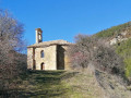

The route starts at a place called Le Moulin, in the commune of L’Étoile-Saint-Cyrice. From the D1075, between Laragne and Serre, take the D30 towards Orpierre, then the D130 towards L’Étoile-Saint-Cyrice. The hamlet of Le Moulin is situated just before the D130/D130A junction: there is plenty of space to park.
(S/E) Continue along the D130 towards Villebois for about one kilometre.
(1) Just before a bridge, turn right onto a forest track that climbs into the woods. The Chapelle Saint-Cyrice is signposted and marked in yellow. The climb alternates between forest track and footpath: after the third hairpin bend, leave the track to follow a footpath on the left which rejoins it further up.
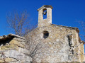
(2) At a hairpin bend that veers to the left, follow the path leading to the chapel, which you can see on your right. Further on, turn left to follow the path that runs between a building and the chapel, which you walk completely around. Then turn left onto a path that leads to the Chapel of Saint-Cyrice in just a few steps.
(3) The Saint-Cyrice Chapel dates from the 12th century and is a listed historic monument. Information boards outline the history of the site.
Retrace your steps for a few metres and take the path that leads off opposite, due south, first running alongside a fence and then into the forest.
(4) At this bend, ignore the path branching off to the left and keep to the right. The yellow markings lead straight back to the hamlet of Le Moulin, very close to the car park (S/E).

 Visorando Member
 Moderate
 Association / Club / Walk leader