Circular walk via the Notre-Dame des Belles Pierres Chapel in Lillois-Witterzée

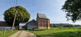
Starting from Lillois-Witterzée station, this circular walk will take you through the countryside between the village centre and the Chaussée d’Ophain. Trails, dirt tracks and a short stretch of tarmac lead you to the beautiful Notre-Dame des Belles Pierres Chapel, before returning along the dirt tracks back to the centre and the station.

Details

n°45989626
Creation:
Last update:
Last review:
  • Walking
    Activity: Walking
  • ↔
    Distance: 3.69 mi
  • ◔
    Average duration: 1h 45 
  • ▲
    Difficulty: Moderate

  • ⚐
    Back to start: Yes
  • ↗
    Ascent: + 108 ft
  • ↘
    Descent: - 108 ft

  • ▲
    Highest point: 472 ft
  • ▼
    Lowest point: 361 ft

Photos

Description of the walk

You can get there by train from Nivelles or Braine-l’Alleud. If travelling by car, park in the station car park: please note, this is a blue zone with a 3-hour time limit. Alternatively, cross the railway line to find a space in one of the streets after the roundabout, then retrace your steps to return to the start of the route.

(S/E) Cross the railway line – you can use the underpass – and follow Rue R. Francq to the first junction.

(1) Turn left, staying on Rue R. Francq, then left again into the small street which continues as the Pré Coquette footpath, until you can see the meadows. Head towards them and, at the three-way junction just ahead, keep left, passing behind the farm, and take the footpath leading behind the school. You’ll pass through a turnstile and, further on, you’ll join Rue Verte, then Rue du Moulin. Turn your back on the railway line and head down the street to the right.

(2) At the next bend, you’ll find the junction with the Aiguemont footpath (a shortcut is possible; see § Practical information). At the first junction, turn right onto Rue de la Croix de Pierre, then left onto Avenue Grand’Peine, for about a hundred metres. At the street lamp, a footpath climbs to the right, between two hedges, leading you to Rue Ramelot. Turn left and continue to the Warchet stables, about 100 metres away.

(3) Turn right onto the path running between the buildings, the Chemin Pierre Charlier. It becomes a country lane, climbs and joins the Chemin d’Ophain. Follow it to the right, keeping straight on all the time – further on it becomes Rue de Griponwez – until you reach the Faut-Bien farm on your right, where you’ll rejoin the tarmac road. Continue along the tarmac road until you reach the path on the left, just past a house.

(4) You can join the rest of the route directly by continuing straight on.
- Alternatively, take the path that enters the woods on your left – Chemin Robin. The path winds up and down. At the first path coming from the right, take it and, when it emerges onto Rue du Bossu, turn right and follow Chemin de la Chapelle up to the chapel.

(5) After stopping there for a few moments, take the farm track that runs alongside it. On your right, you’ll have a view of the route you’ve just taken. You’ll arrive at a farm on Vieux Chemin de Nivelles. First turn right then left to take a path running along the back of the garden, which will lead you to Rue des Salanganes near the cemetery.

(6) Carry on straight ahead, go round the roundabout on the right or left and continue straight on until you reach the junction where the circular route ends.

(1) Retrace your steps in the opposite direction until you reach the station car park (S/E).

Waypoints

  1. S/E : mi 0 - alt. 423 ft - Car park at Lillois-Witterzée station
  2. 1 : mi 0.13 - alt. 417 ft - Junction of the circular loop
  3. 2 : mi 0.59 - alt. 407 ft - Rue du Moulin – Aiguemont path
  4. 3 : mi 0.95 - alt. 427 ft - Warchet Stables
  5. 4 : mi 2 - alt. 387 ft - Chemin Robin
  6. 5 : mi 2.51 - alt. 410 ft - Notre-Dame des Belles Pierres Chapel
  7. 6 : mi 3.33 - alt. 413 ft - Rue des Salanganes
  8. S/E : mi 3.69 - alt. 423 ft - Car park at Lillois-Witterzée station

Notes

Alternatives:
- After (1): at the three-way junction after Rue René Franck, you can continue straight on along the Aiguemont path. You will need to cross the meadows a little further on and you will arrive directly at point (2).
- At (4), at the fork, carry on straight ahead to reach (5).

Worth a visit

Visit and reflect at the Notre-Dame des Belles Pierres Chapel.

Reviews and comments

4.7 / 5
Based on 1 review

Reliability of the description
5 / 5
Ease of following the route
5 / 5
Route interest
4 / 5
Patrick Vanbellinghen

Hello Marie-Françoise,
Thank you for these entirely valid comments, which are no doubt due to a system bug at Visorando, as the data comes from them and not from me. I’ll let one of the moderators know so they can make the necessary changes. As for the comment about “different ascents and descents”, strangely enough, I notice this on every hike, whether it’s one I’ve done or one done by others. And I don’t understand it either…

I wish you many more wonderful hikes.

Machine-translated

Seny Marie-Françoise

Overall rating : 4.7 / 5

Date of your route : May 20, 2024
Reliability of the description : ★★★★★ Very good
Ease of following the route : ★★★★★ Very good
Route interest : ★★★★☆ Good
Very busy route : No

A few minor corrections to make:
-: 2 hours are enough (not 4!) to cover these 6 km.
- Elevation gain: no more than 100 m (so not 909 or 960 m)
As it’s circular, the elevation gain equals the elevation loss!!!!)

Machine-translated

Other walks in the area

For more walks, use our search engine .

The GPS track and description are the property of this route's author. Please do not copy them without permission.