Country:
 City:
City:



The starting point is at the “Veyrier, Pont de Sierne” bus stop. For those travelling by car, you can park further along, at the junction of Chemin de Naville and Route de Florissant, but this means a short walk to reach the starting point.
(S/E) From the bus stop, head up to the hamlet of Sierne via the fairly steep Chemin du Pont de Sierne.
(1) Just at the top, turn left onto the track (heading north-east) and follow it down, keeping the gravel pit on your left.
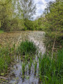
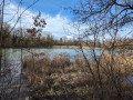
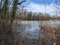
(2) At the bottom, leave the track and turn left onto the path that runs along the edge of the woodland and leads to the wooded banks of the Arve. Historic boundary stones engraved with ‘G-S’ (Geneva and Savoy) indicate where you cross the border between Switzerland and France. Continue along the path between the Arve on your left and the Étang des Petites Îles on your right. At the large crossroads, turn right onto the wide, straight path that goes round the pond and heads south.
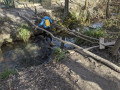
(3) Just as the wide path leaves the pond, turn sharply right and follow a path that is somewhat overgrown. Be careful not to miss this path, which runs between the lake on the right and some villas on the left. Shortly after the ford, pass the handrails (see photo) that cross the little stream known as the Eaux Belles. Carry on until you reach a wide path and some fields. Continue to the left, along the path, until you come to a cemetery.
(4) At this crossroads, you’ll cross the border between France and Switzerland: a sign with instructions indicates this. Carry on straight ahead through the village of Veyrier. Cross the Route du Pas de l’Échelle and turn into Rue des Boulangers opposite. Follow Chemin de Sous Balme, then Chemin des Marais, to reach the village outskirts at a triangular junction.
(5) Turn left onto Route des Tournettes, then turn right onto Chemin des Diocès, which runs through the market gardens. At the end, turn right and cross the road (Chemin des Marais) to join Chemin de la Marettaz.
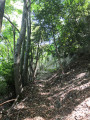
(6) At the left-hand bend, carry on straight ahead to enter the woods of Veyrier. Walk through them to reach the road known as the Chemin du Bois Gourmand. Cross this road and continue straight on into the woods.
(7) When you reach an area of detached houses, turn right until you reach the road known as Chemin des Bois. As soon as you reach it, turn left onto the footpath through the woods. This gradually curves to the left and ends at a school building. Walk past it on the left to reach Route de Veyrier.
(8) Cross the road and take the path into the woods opposite, slightly to the right. Continue straight on, keeping the Ruisseau du Nant du Bois-Carré on your left.
(9) When you reach Route du Stand de Veyrier, cross it carefully to join, on the opposite side, the path that runs along the top of the rather steep banks of the Arve. Turn right to follow this well-marked path, which overlooks the Arve’s striking turquoise or grey waters; the colour changes with the weather and flood levels. Continue until you reach the bus stop where you started (S/E).


 Visorando Member
 Difficult
 Very difficult
 Moderate